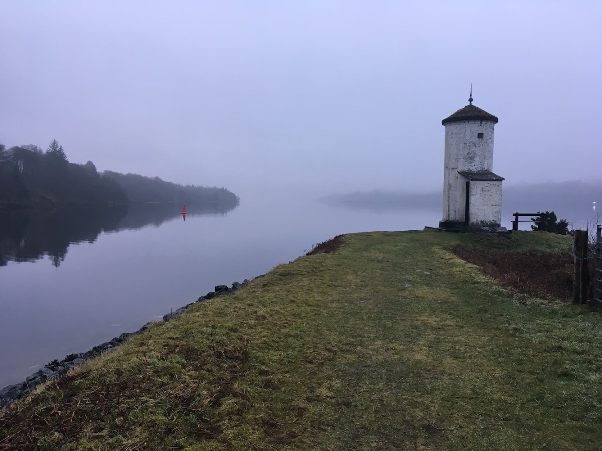
Continuing my gentle re-introduction to normality, having seen two lighthouses yesterday, I simply had to see one today. I’d had a distant view of the lighthouse at Gairlochy on the banks of the Caledonian Canal a few years ago, but time limitations meant I’d not been able to walk to it at that time. This morning was the perfect opportunity though while travelling between Fort William and Inverness.
It’s a great little walk and considering it was a Sunday morning it was surprisingly quiet. I passed one person just as I set off, but that was it. There was rain in the air and maybe that had put people off, but otherwise it was a nice morning. The water was as calm as it could possibly be. The banks of the canal are lined with trees of varying shapes and sizes, which looked fantastic today with the reflections in the water. With low cloud added into the mix, it was all very atmospheric. The positioning of the lighthouse in relation to the surrounding land meant I couldn’t see a reflection of the tower itself in the canal, but as I’ve said a lot recently, you can’t have everything.
Gairlochy lighthouse and the Caledonian Canal
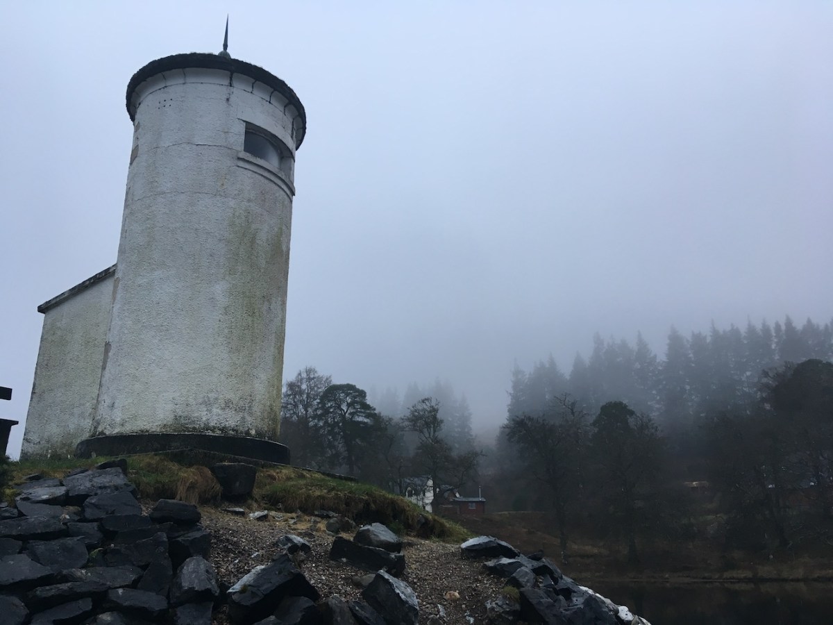
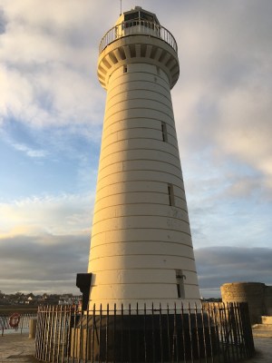
The tower is very similar in style to others dotted along the canal, namely Fort Augustus and Corpach. I think they’re a likeable sort of tower, very understated, they just get on and do their job, but in such beautiful locations. There are a couple of nice little touches on the Gairlochy light that make it stand out a little, such as the small porch area leading to the curved door (it’s not often you see a curved door). The lighthouse also features the year it was built, 1932, a tiny hint at a celebration of its own existence. Otherwise, it seems to happily sit there minding it’s own business
Gairlochy lighthouse
You can always tell that a lighthouse is easy to get to and frequently visited when it has a bench next to it! A nice little spot to relax and clear your mind – if you can spare the time for such luxuries. Today was not a day for that as I had to get back to Bob and the kids, and continue the journey home. Back I went along the towpath, a walk I would be more than happy to do time and time again. One day I will sit on that bench and enjoy the beauty of it all. I may even have a little chat to the lighthouse too – or would that be taking things too far?! Probably.
I have a feeling that this will indeed be my last blog post for a little while – maybe six whole weeks in fact. In the meantime I shall be busily working away on the book whenever I possibly can 🙂
After such a fantastic couple of lighthouse days – or do I mean weeks, or maybe even months?! – I needed to gently be brought back down to normality. Today has been the day for that with a short boat trip to see a couple of minor lighthouses at the north end of the Sound of Jura.
Craignish Cruises were the boat operator of choice for today’s trip from Ardfern. Originally it was just going to be me on the boat while Bob manhandled the kids. Having seen details of the boat (a heated cabin!) online last night we asked Lindsay, who owns the boat, if he would be happy for the kids to go too. He was fine with that, so off we set.
It’s not quite so easy bagging with young children and the constant demands, but it helps towards my plot to turn them into the next generation of lighthouse baggers. The bagging is definitely strong in the eldest. The younger one still needs some work!
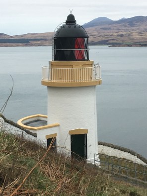
The tide was against us on the way out, but it wasn’t too long until we arrived at the tiny island of Ruadh Sgeir. It was interesting hearing the opinions of both Lindsay and Don who was helping him out on the trip. Lindsay has always thought the light was quite sweet (he seems quite fond of lighthouses, even the small ones, from the point of view of someone who uses them for their intended purpose – aiding navigation). Don, on the other hand, said he thought it was just a light on a rock. I think it deserves more credit and, I’m sure, by the end of the trip he was beginning to see the beauty of lighthouses, even the small ones. It’s quite common for boatmen to say that they have travelled along a stretch of coastline frequently and never noticed the lighthouse. They just need to be enlightened (no pun intended), that’s all.
Read Sgeir lighthouse
I really like the Ruadh Sgeir light. I’m a fan of this type, and I always think there is a lot more to them, in terms of design, than they get credit for. It’s not just a small white tower that’s been dropped on a rock.
Our second stop was Reisa an t-Sruith. Lindsay told me this translates as ‘island in the strong tidal current’. There is certainly a lot of movement in the area, in terms of tides. It looked a lot choppier than it felt. Like Ruadh Sgeir, Reisa an t-Sruith is just a small island, a slightly bigger small island than Ruadh Sgeir. The lighthouse is a standard Northern Lighthouse Board flat-pack. Not much more to say about it other than that. It replaced a light designed by David A and Charles Stevenson. The island itself is home to some goats who watched us from afar, probably wondering what on earth we were up to. I’m assuming they don’t think much of the lighthouse!
Reisa an t-Sruith
As well as the goats, our wildlife tally increased again today with a brief appearance of a pod of 4 to 6 bottlenose dolphins.
A short, but important trip. It marks a first round completion of the wonderful lights of the Islay and Jura area. In such a short space of time, it’s been quite full-on, but not rushed. I definitely want a closer look at the Rinns of Islay at some point, but for now I’m satisfied – and of equal importance, I got those much-needed pictures for my book.
This afternoon we paid an enjoyable visit to Ian who served on Skerryvore lighthouse and who visited that very lighthouse with us last year (see this post for more on Ian). He and Doreen are wonderful hosts and it was lovely to catch up with them.
Now back to reality. I always put a smiley face at the end of these posts and I’m going to do the same for this one as it’s been a good day and I’m hopeful that it won’t be long until my next post. There certainly is plenty of lighthouse fun lined up for the year 🙂
What a day! In this lighthouse bagging game you experience some days where, at the end, all you can do is throw yourself onto the sofa and say “wow, did that really happen?”. Today was definitely one of those days.
It’s our final day on Islay and Bob had been in touch with Gus and Rebecca from Islay Sea Adventures in the lead up to our visit to Islay to sort out a trip taking in some of the lighthouses in the Sounds of Jura and Islay. Gus had said that Friday looked to be the best day for it, so this morning we arrived at Port Ellen and spent a while throwing on even more layers in preparation for a RIB trip in January (mental!). You can’t imagine my delight at seeing a beautiful covered RIB gliding into port. Covered RIBs are my favourite!
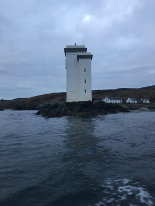
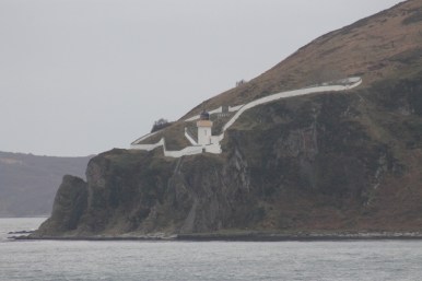
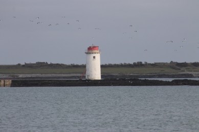
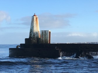
Port Ellen/Carraig Fhada lighthouse
Before we’d even got on the boat, Gus offered us a cup of tea and we chatted to Gregor who was helping him out on the boat while Gus went for the hot drinks. A short time later, and with tea firmly in hand, we set off and Gus offered to sail around the Carraig Fhada/Port Ellen lighthouse on the way out. It was great to see a bit more detail from the sides you can’t see from the land. We asked Gus if the walkway is covered at high tide and he said that it can be, and that a man and his son were washed away trying to reach the lighthouse about 100 years ago. Regardless of that, it really is a lovely tower, and the sentiment behind its history is wonderful (more details of this can be found on the Canmore website). I would be quite happy to have a lighthouse built for me (preferably while I’m still alive). With the cost of the recent trips though, I don’t think Bob would be very willing to oblige!
Back on the waves, or lack of I should say, off we went again. A short time later we passed a few small islands and spotted a couple of sea eagles closer than I’ve ever seen them before. They are very impressive, but I wouldn’t want to be get too close!
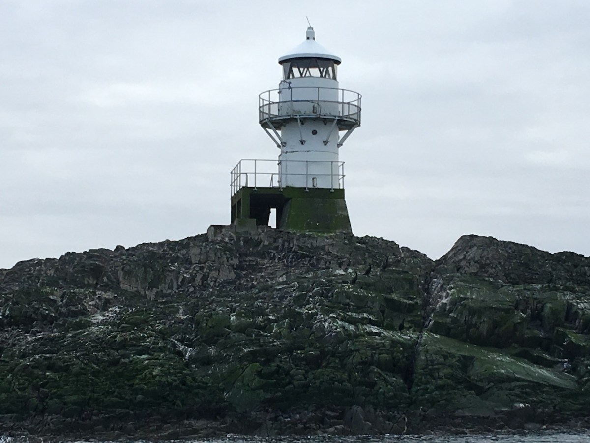
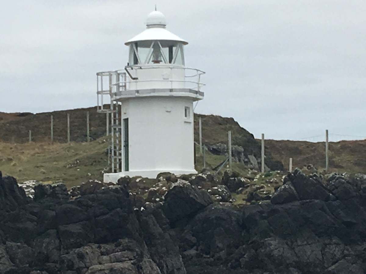
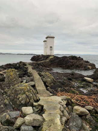
Eilean a Chuirn was destination number 1. I really like this kind of lighthouse, although I’m not entirely sure why it needs so many doors – perhaps so they can access it in high winds and which door they use depends on the wind direction. That sounds like the only plausible reasoning and would be my guess anyway. It’s a lot like the Waternish light on Skye. Gus explained that the large concrete block next to the lighthouse was part of the pulley system used for moving supplies from the landing point to the lighthouse.
Eilean a Chuirn lighthouse
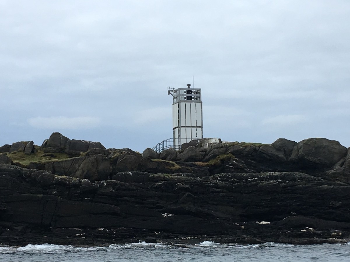
After a quick wave to McArthur’s Head, more on that one to follow, we went onwards to Na Cuiltean, which I’d seen from a distance from the ferry on Wednesday. It’s basically a solid platform with one level of the Northern Lighthouse Board’s flat pack arrangement on top. The base of the structure clearly takes a bit of a battering at times. One side of the base is almost completely covered in a layer of green algae and birds are obviously very fond of the rock it sits on!
Na Cuiltean lighthouse
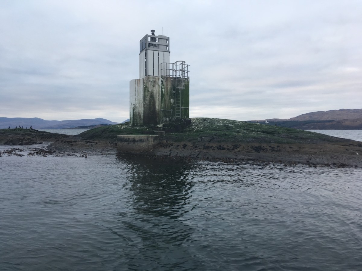
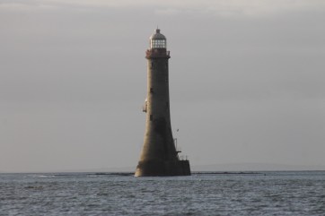
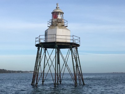
I was very excited about the next one. Skervuile isn’t really that far from land, but the land it is close to is very remote and fairly inaccessible, which makes seeing this one a bit of a challenge. I’d seen it as a small white pencil of a thing in the distance from the ferry. As we approached it was getting bigger and bigger and yet there still seemed to be some distance to go. It reminded me of a term I’d heard from Christian Nock who walked around the coastline of mainland UK: “lighthouse syndrome”. Anyone who has ever walked any distance to a lighthouse will know the feeling. You see the lighthouse and think “Great, I’m nearly there” and an hour later you are still walking towards it. Well, the approach to Skervuile was a little like that, except it wasn’t an hour. We did eventually get there though and I was very surprised to see the rock below it exposed. All of the pictures I’d remembered of it were at high tide where the sea completely surrounds the base of the tower. With the tide fairly low, the small landing platforms were also exposed. As with all rock lighthouses, I stood staring at it thinking “wow, I have no idea how they built that, but I’m so glad they did”!
Skervuile lighthouse
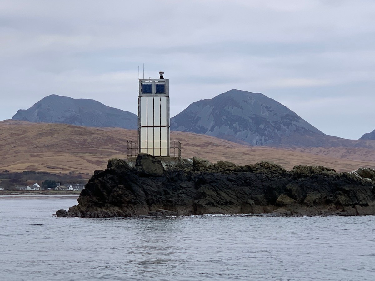
Eilean nan Gabhar was next on the agenda as we sailed back down the Sound of Jura. This one is a fairly standard flat pack, except it’s a flat pack with those Paps in the background from certain angles! I’ve become a little obsessed with getting pictures of lighthouses with the Paps of Jura in the background. The joy of it being that it is very easily done in the Islay/Jura area. I believe the term “commanding the landscape” is very apt as that is exactly what the Paps do – well, until you stick a lighthouse in front of them, of course!
Eilean nan Gabhar lighthouse
Another wave to McArthur’s Head as we entered the Sound of Islay. The ferry had given us a very good view of Carraig Mhor, to the south of Port Askaig, on Wednesday, but this was an opportunity to get even closer. Not landing close (although that would have been possible, but was not a priority for today). With the reduced elevation compared to the ferry, and the calm sea conditions it was also a good chance to catch some nice reflection shots. Love a reflection! It still looked from our closer angle like it would be quite difficult to access by land.
Carraig Mhor lighthouse
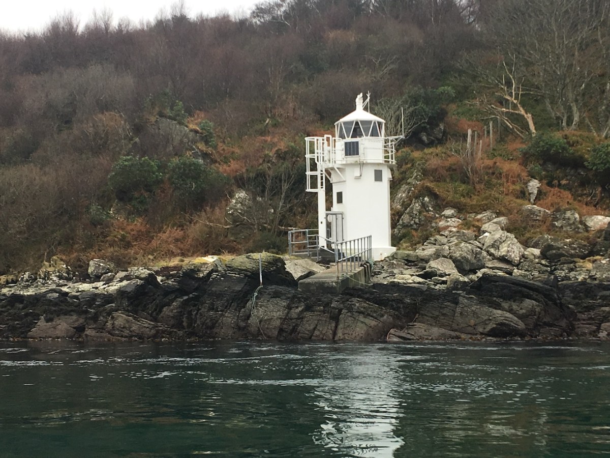
From the ferry on Wednesday, I’d quickly caught the little lighthouse, Carragh an t-Sruith on the west coast of Jura. Very similar in appearance to Eilean a Chuirn, this one looks to be a nice little walk from the landing point for the ferry across the short stretch from Islay. Must put that on my “to do” list.
Carragh an t-Sruith lighthouse
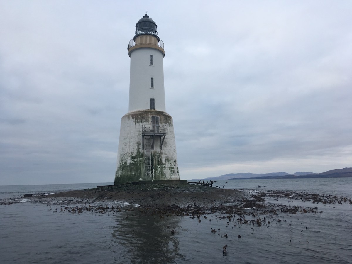
Ruvaal hadn’t been part of the original plan, but I asked Bob this morning if we would be going that far. I think he sensed from my tone that I wanted to go there. We asked Gus nicely and he was more than happy to add it on. On the way there he told us about the couple who own the lighthouse and how they manage being such a long way from a road. The majority of their journeys to Port Askaig are done by small boat. They do have a quad bike to drive across the difficult terrain, but Gus explained that the land they cross is mostly mud. He had once driven up there on the quad once with a passenger and saw a big puddle, which he thought he could get through. As it turned out, a pole had blown down in the wind and had been removed along with its base, leaving a gaping chasm (my words, not his). So, Gus ended up stuck in this gaping chasm with water almost up the seating level in the quad. Fortunately he was able to get them out and back on the track. The challenges they must face seem endless to me and it would take a certain type of person to be able to live (or enjoy life) there. As much as I love lighthouses, I would need to draw the line when it comes to choosing which one to live in, and Ruvaal falls below this line! Having said that, the lighthouse is beautiful. Incredibly slender! If I were a lighthouse, I would want to look like Ruvaal. It was lovely to sail around it and see the side with the windows too. Maybe I could live there – perhaps – just for a few days.
Ruvaal lighthouseMcArthur’s Head lighthouse
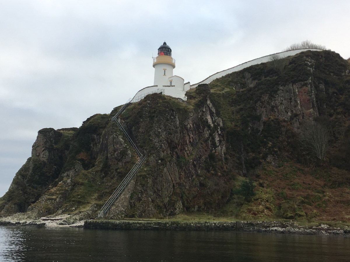
We had purposely saved McArthur’s Head for the way back. We’d rather cheekily asked Gus if he thought it might be possible for us to go ashore there and climb those glorious steps. He explained that it is not possible to land at low tide, he’d once been stranded in a nearby cave due to the tide going down. To maximise our chances of landing, he suggested saving it until the end of our trip when the tide would be in. He wasn’t wrong and I may have squealed a little (just a little) when he said that he’d get us in! We hopped ashore and made for the steps. I approached the steps thinking that there weren’t that many and it would be easy enough. About 10 or so steps from the top I changed my mind. It’s a long way up! But it was so worth it. The lighthouse, while not unlike a number of others in the area, was stunning and the extra effort you put into getting to it adds to the enjoyment. My favourite views though were from the end of the path beyond the lighthouse looking back at it with Jura in the background. Just beautiful. Gus told us that the lighthouse was painted last year and they flew in 2.5 tonnes of paint for the job. I imagine at least half of this paint was used on the wall rather than the tower itself. The wall is so long that I didn’t even realise we were inside it! McArthur’s Head now holds the record for the most number of hugs it has had from me (3). I even enjoyed walking back down the steps. I can’t decide though whether the lighthouse looks better from the land or from the sea. It is just an all-round wonderful lighthouse and I want to go back already!
McArthur’s Head from the sea
Heading back to Port Ellen, the sea eagles were out in force again, being wound up by some gulls. Gus had told us about a group of stags he’d seen swimming between islands near Eilean a Chuirn the other day. By some wonderful chance, we spotted one in the water as we passed. Gus did a very quick and very sharp turn in the RIB to enable us to see the deer swimming at close range. After it arrived on the island it looked back at us briefly before wandering off onto the island.
A wonderful and very successful day. Certainly one never to be forgotten. 🙂
For a change, today has been a shorter day. In a recent post I mentioned the benefits of winter: being able to catch lighthouses at sunrise and the lights in action. The downside, though, is the later starts and earlier finishes. It’s still been a productive day though.
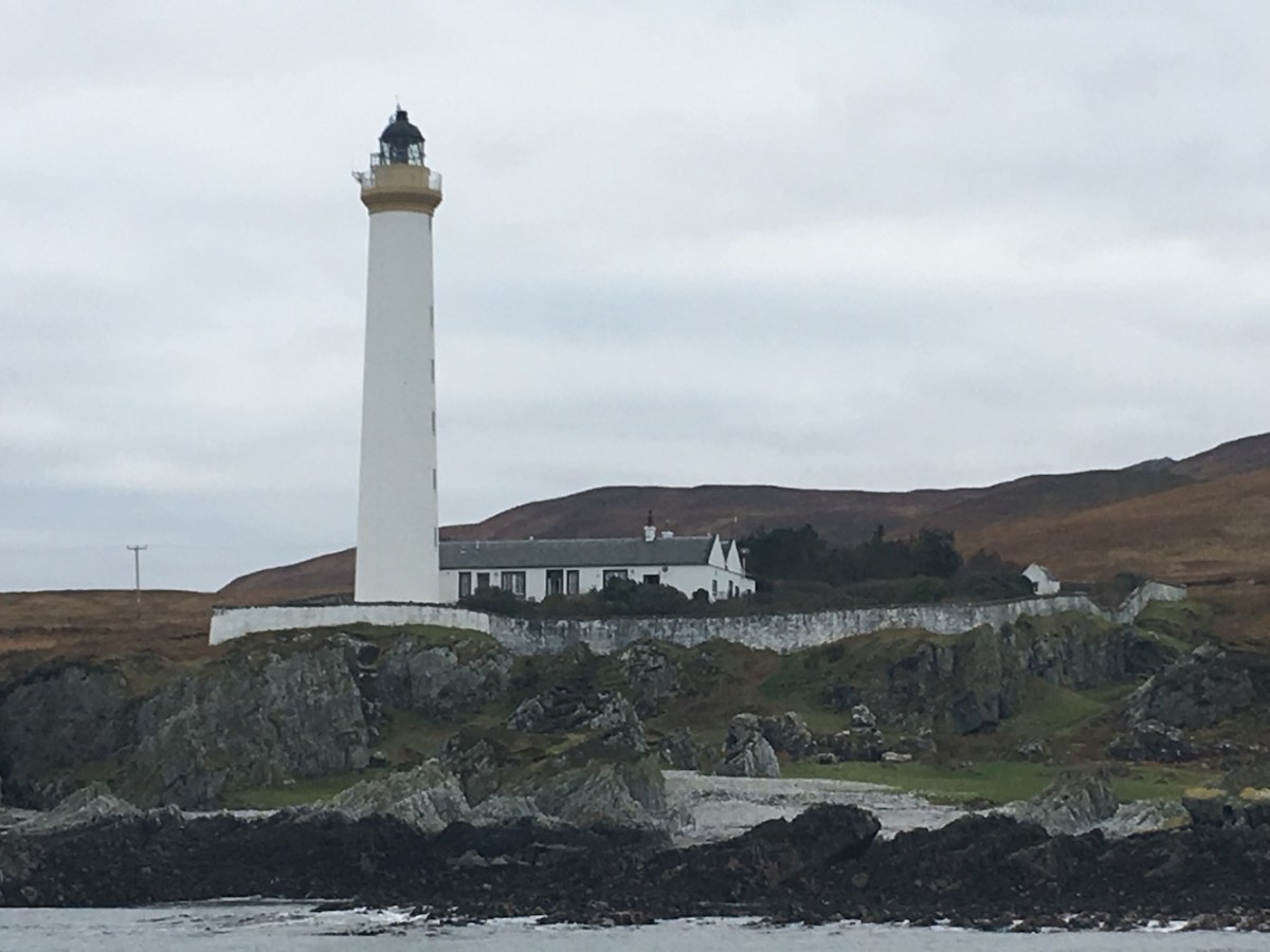
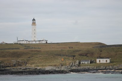
Two lighthouses beckoned this morning, and when they call one must go! The first was the Rinns (or Rhinns) of Islay, which resides majestically on the island of Orsay off of Port Wemyss. On the way there we passed what was to be our second stop of the day, Loch Indaal at Port Charlotte, and had a quick look at how we might be able to get access to it. While the field to the north of Loch Indaal House (which is available as a holiday let – the views of the lighthouse at night would be wonderful from there, I imagine) was home to a few young Highland cows, the field to the south looked a lot more inviting with just a few sheep roaming around. Back to that one shortly.
Rinns of Islay lighthouse on Orsay
As we approached the small but very picturesque village of Port Wemyss the Rinns of Islay lighthouse just appeared out of nowhere, considerable bigger than I expected it to be. While I knew it wasn’t a huge stretch of water between Port Wemyss and Orsay, I hadn’t expected it to be so close. One of the first views we had of the lighthouse was fantastic. Heading straight for the coast with houses on either side of the road, the lighthouse was perfectly positioned at the end of the road, looking almost like you could drive right up to it. There are some wonderful spots to get views across to the island and lighthouse from the coastal road. A perfectly positioned picnic bench is just up the hill slightly from the slipway. A wonderful spot to spend some time “lighthouse gazing” and enjoying the moment. One day I hope to make it across to the island, but it’s not on the plan for this week. Something to look forward to another time.
Loch Indaal lighthouse
Returning to Port Charlotte, we parked up in the village and wandered along the road until we reached Loch Indaal House. I asked my usual “are you sure we’re allowed to go through this field?” and Bob reassured me for the 500th time that it was absolutely fine – we are in Scotland and there is “right to roam”! Onwards we went. I’d already said that I wanted to get a picture of the lighthouse with the Paps of Jura in the background, so we walked slightly further south before heading to the lighthouse. The best place to get this picture is actually from the road where the Paps still manage to look about the same height as the lighthouse! Where yesterday the Paps made Na Cuiltean lighthouse appear so small and insignificant, Loch Indaal light won this time, but only once we’d made it to the bottom of the field! It did make for a lovely view. No blue skies today, but also no rain and very little wind. It’s a nice rocky area to wander around and we slowly made our way towards the lighthouse. The tower is a fairly straightforward affair and reminded me a lot of the tower at Corran. It’s no wonder really as they were both the brainchild of the wonderful Stevenson team that was David and Thomas, with Loch Indaal first lit just 9 years after its twin on the mainland at Corran. I mean, why reinvent the wheel?! Interestingly, the Northern Lighthouse Board (NLB) face plate next to the door says “Loch Indaall”, but most spellings appear to only have the one ‘l’ on the end – even in places on the NLB website. It’s not the most astounding of lighthouses, but it’s really easy to get to and in a lovely location.
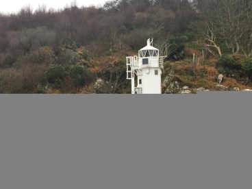
Port Ellen/Carraig Fhada lighthouse
After a lunch break, we hit the road again with Bob shuttling us all (the four of us and his mum) to Port Ellen in two runs. I was dropped off first which gave me the chance to go on ahead to the Port Ellen lighthouse, which in these parts is more commonly referred to as Carraig Fhada. It’s a nice little walk around the coast and the lighthouse is visible pretty much all of the way along. It doesn’t resemble a lighthouse in the traditional sense, but it looks wonderful and you just can’t help but take numerous pictures on the approach. Well, I would have done just that had a couple and their two dogs not entirely ruined my view by walking out to the lighthouse at completely the wrong time. I can’t complain about them too much though as the man pointed out a heron on the rocks on the way out, so I managed to get some decent pictures of a heron (not really my sort of thing, but good to have to share with my birdwatcher dad). The best pictures and views though, in my opinion, are to be had near the entrance to the narrow walkway that leads out to the lighthouse. When you see a little walkway like that there is nothing for it, you just need to walk it. It could be pretty hairy at times I imagine and completely unwise to walk out in rough sea conditions, maybe even verging on impossible without getting washed away. I was splashed a little once on the way out and today has been really quite calm. It’s a great little wander. There’s not a lot to see once you are at the lighthouse. It’s a relatively small rock that it sits on, so you can’t get any decent pictures of the tower. Crossing back over the walkway I made my way back towards the cemetery where I’d been dropped off and met the others on their way to the lighthouse. We all bagged the lighthouse and had a walk along to the Singing Sands, which didn’t appear to be singing today (apparently the wind was coming from the wrong direction). On the way back to the car, I managed to get those pictures I’d missed out on due to “that couple” with the dogs. All was well in the end.
I should add that, as we arrived in Port Ellen this afternoon, I spotted a few flashes straight ahead. Considering it was still daylight at this point, I was quite amazed, and intrigued. Looking at the map, I wondered if it might be one of the lights on Rathlin Island off of the north coast of Northern Ireland, most likely Altacarry Head. Bob wasn’t sure. Having looked into it a little more though, I am very pleased to have been proven right. Altacarry Head, or Rathlin East, lighthouse does indeed flash 4 times every 20 seconds as we had seen and, very interestingly, does so 24 hours a day! This has been the case since November 1995 and was introduced to “improve the daytime conspicuity of the station”, as stated on the Commissioners of Irish Lights website. That explained everything.
That’s all for today. More to come tomorrow (she says, with crossed fingers)! 🙂
Happy New Year to you! I’m not sure I’ve managed to say that in a blog post before with the key reason being that bagging season for me doesn’t usually start until at least March. Winter isn’t always conducive to enjoyable lighthouse visits, although last weekend’s trip to Northern Ireland is evidence that it’s not necessarily the case.
Feeling the need to continue the brilliance of last year, and fill some gaps in pictures required for my book (see this earlier post for details of this), a little time in the Islay and Jura area was required. It’s very much been uncharted territory for me so far. It’s also not the easiest area for visiting lighthouses as some of the lights aren’t so easy to access, being either on rocks in the middle of the water or involving a long distance walk on very rough or boggy terrain.
Ardrishaig lighthouse
There is a plan to address this later in the week – more on that in a couple of days, all being well. Before that though, today has been a day of “glimpsing” the lights, almost in preparation.
Travelling from Ayrshire to Kennacraig to catch the ferry, we stopped on the west bank of Loch Fyne at Minard. From here the black and white Sgeir an Eirionnaich (or Paddy Rock) light can be spotted. From such a distance there’s not a lot to say about it, except that one day I hope to get a little closer! Continuing the journey south, we gave the lighthouse in Ardrishaig a quick wave as we passed.
McArthur’s Head lighthouse
We weren’t sure what it would be possible to see from the ferry between Kennacraig and Port Askaig, more specifically the section to the south of the Sound of Jura. I braved the elements and stepped outside with the zoom lens in tow. At first I spotted a white tower in the distance and, checking the map, established that it must have been Skervuile. I was actually on the look out for the Na Cuiltean light at the time, not expecting to see Skervuile, so that was a bonus. I’m really looking forward to seeing Skervuile close up (fingers crossed it will happen this week). Scanning the coast, I finally caught sight of the Na Cuiltean lighthouse, another one to get closer to. It’s not a huge tower anyway, but even if it had been it would have been dwarfed by the incredible Paps of Jura in the background. What an island Jura looks to be from the sea!
I’d had my eye on McArthur’s Head between views of the two lighthouses to the north. I had a few minutes to go back inside and warm up a bit, before it was time to head out again on the approach to the Sound of Islay. Although I’d never seen it in person before, the lighthouse and its surrounding wall at McArthur’s Head are very recognisable. It was wonderful to pass it and see it from a number of different angles with more detail of the landscape emerging with every moment.
Carraig Mhor lighthouse
The final lighthouse of the journey was Carraig Mhor just to the south of Port Asking. There was no need for a zoom lens for this one. The small, but perfectly formed tower would not even be worth attempting to visit from the island itself, but the very surroundings that make it so inaccessible from land is exactly what makes it such a picturesque view from the sea. The lighthouse is nestled there quite happily with its own jetty.
I’d just started to make my way back inside again when I remembered there was one left to see – Carragh an t-Sruith on Jura. We weren’t particularly close to it, but it was visible and yet another one for later in the week – hopefully. As I said, it’s been a glimpsing day with hopefully better views and clearer pictures to come. 🙂
While yesterday was all about visiting new lights in the north of Northern Ireland, today the objective was to improve upon those we’d seen a few years ago along the south and east coasts.
In the lead up to this trip we had been in contact with a local boat operator who had an unconfirmed booking with another group, but had said he would be happy to take us along Carlingford Lough for closer views of Haulbowline as well as the two smaller lights, Vidal Bank and Green Island. Unfortunately, we were informed that the other group’s trip was going ahead so it wasn’t possible for us. Although Bob tried to make contact with an alternative operator, we had no success. The back-up plan was paddling!
We’d been lucky with the tides yesterday for seeing the lights on the banks of the River Foyle and, in particular, managing to get close to the Otter Bank light. Today, we decided to make sure the tide was in our favour again. It obviously meant an early start, as is often the case with these lighthouse days, although thankfully not as early as yesterday.
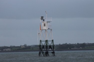
Vidal Bank
Arriving in Greencastle, we decided to have a drive around to see the nearest place to see the lights from, focussing first on Vidal Bank and Green Island. As usual, Bob chose to park somewhere that I couldn’t possibly recommend people park when they actually visit themselves, but fortunately we checked out the access suggestion I will include in my book and that was fine. We walked onto the beach, wellies on, and I headed straight towards the Vidal Bank light, walking in as far as I could without getting my feet wet. It would not have been possible to get to the light, or its neighbour Green Island, anyway so it wasn’t worth even trying. We had the zoom lens so that helped with getting better pictures anyway.
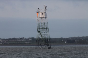
Green Island
There were a number of oyster beds nearby and we strolled alongside them to reach the closest point to Green Island. Again, in I went to get some pictures, while Bob hung back on the beach using the zoom lens! There’s not a lot of difference between the two lights, but we did spot that the green section of the legs on the Green Island light came further up than on Vidal Bank. Also the orange triangular daymarks on them were in different orientations and at different heights. This may sound like unnecessary information, but will prove to be very useful for working out which is which in pictures. Having seen the pictures included here so close together it is obvious that they are a bit different.
Haulbowline lighthouse
While we’d been hanging around the smaller lights, we were very aware that the beautiful Haulbowline rock lighthouse was a short distance away. It was even less likely that we would reach this one at low tide, but I felt that need to paddle again. This time I had the zoom lens, which helped. The sun was still low and I always think this is one of the benefits of visiting lighthouses at this time of year, as you can catch the colours of sunrise and sunset on the towers without having to get up at some ridiculous hour or stay up too late. Haulbowline has all the magnificence and elegance of a rock lighthouse, but without the need to spend hours on a boat to reach it (well, technically we had to get the ferry to Northern Ireland, but you hopefully see my point). There were some beautiful houses along the north bank of Carlingford Lough and I can see why. If I had a potential view of Haulbowline from my house I’d want massive windows too!
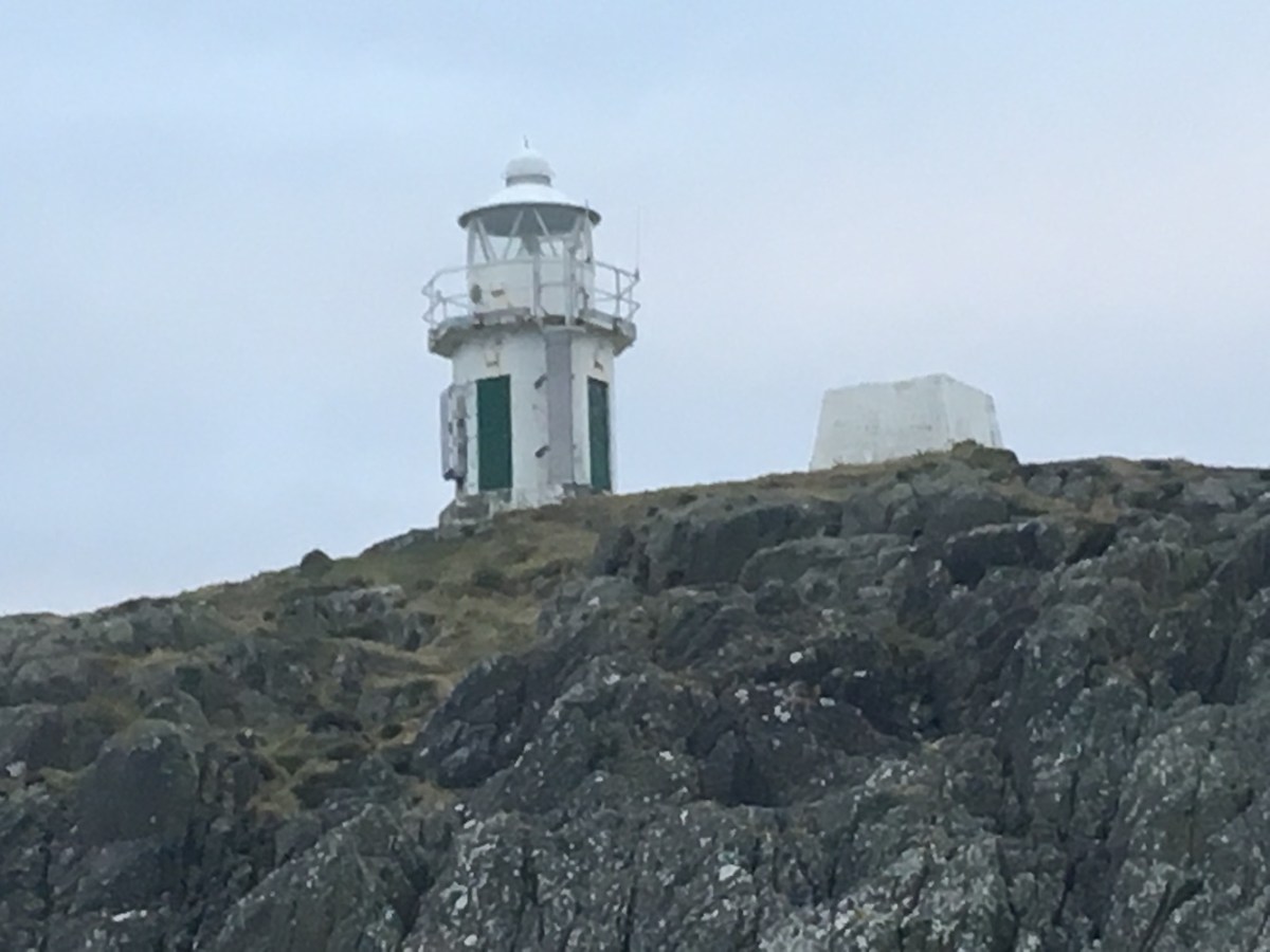
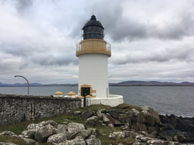
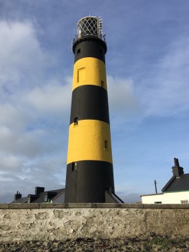
St John’s Point lighthouse
From here we headed north. I was very keen to get back to St John’s Point to improve upon the pictures we got last time. The problem with them was that it was a pretty overcast day and as there was blue sky this morning it seemed like an opportunity not to be missed. In addition, the lighthouse has yellow and black stripes, which is very unique and is one of things I like most about it. Driving past it would have felt very wrong. I was really pleased in the end to go back there. The joy of lighthouse revisits is that you so often notice smaller details that you didn’t see before. There is a narrow slipway leading up to the lighthouse from the coast, and there are a couple of signs clearly warning people that they use it at their own risk. On one of the walls around the compound were a number of stones with names and messages written on them. Many had the dates that people had visited. Just below these stones was a small area with a few items and a large stone explaining that it was in memory of a little boy, Noah, who only lived for 9 months. It was very sad and these things always touch you more when you have children of your own. I did think it was a wonderful thing for his family to have done. He may not have reached an age at which he could enjoy a lighthouse, but it will now always be an important place to his family.
Ardglass
Another interesting observation from this visit was a banner on a gate near the entrance to the lighthouse. The tower’s optic is clearly under threat at the moment and the local community are, of course, wanting to challenge it. The campaign is being run by Lecale Lightkeepers, a cross-community group, and their banner calls for help to save their “iconic sweeping beam” with “Leave St John’s light alone” along the bottom. I am a huge fan of sweeping beams, you just can’t beat them and I’m always sad to see them go. The banner urges supporters of the campaign to email the Commissioners of Irish Lights.
We followed our visit to St John’s Point with a quick stop at Ardglass Pier, another revisit. There’s not a lot to say about this one, but we got blue sky pictures again – once again an improvement upon last time.
Angus Rock
It was time for a little distance bagging on the stretch between Ardglass and Donaghadee. I very helpfully noticed (if I do say so myself) that a ferry ran across Strangford Narrows, which certainly made the journey a lot quicker. It also meant that we had the opportunity to see Angus Rock lighthouse from both sides of the entrance to Strangford Lough. Out came the zoom lens again and the best views of it were certainly from Kilclief on the west bank. We’d spotted Angus Rock on our first trip to Northern Ireland, but hadn’t made an effort to get as close to it as possible, so this was another chance to do just that.
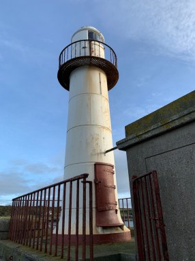
A distant view of South Rock lighthouse
Our next distance viewing was of South Rock, also known as Kilwarlin lighthouse. While it isn’t looking too special now, it has an interesting history since it was first lit in 1797 and it was the first rock, or wave-washed, lighthouse in Ireland as a whole. From the coast of mainland Northern Ireland you can’t really see its true magnitude, but hopefully one day we will make it out there for a closer look.
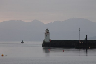
Donaghadee lighthouse
Passing Donaghadee without stopping to walk to the lighthouse should, quite frankly, be made illegal! Not wanting to break this new law I have just introduced, we spent a while on the pier there. By this time sunset was well and truly on its way, casting that wonderful warm glow over everything once again. The only problem with Donaghadee is that too many people seem to recognise the enjoyment to be had from walking to the lighthouse. While I love to advocate lighthouse bagging, I do like people to keep out of my pictures most of the time, unless I choose to have them there! Once again a great place and clearly somewhere that all ages enjoy judging by today’s visitors.
On the coastal road north towards Belfast we spotted the black and white stripes of the Mew Island lighthouses off of the coast, precisely at the point my notes had suggested viewing it from.
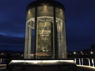
The old Mew Island optic, now in Belfast
There was one final place to be visited before we could go to the ferry terminal. I alluded to the old Mew Island optic in my post yesterday, and how it has now been relocated to the Maritime Mile as part of the Titanic Belfast museum. During our first visit to Northern Ireland we had flown out to Mew Island in a helicopter (I had great fun, Bob was petrified when I took control though!) and we had seen the optic rotating in the lighthouse. Since then the optic has been replaced by a modern light. The optic is now being very well cared for and is beautifully presented and lit in its new home (which apparently is at the location of a former harbour lighthouse). There is a great deal of information on the boards surrounding it too about the history of the optic, the type of lens (it is one of only 30 Hyper-Radial lenses in the world for those interested) and the movement of it from the lighthouse to the Titanic Causeway. I was pleased to be visiting as it was getting dark to fully appreciate the display. I was also pleased that it is outside as it is accessible 24 hours a day and free of charge! There’s a lot of information about the lens at https://greatlighttq.org if you’d like to find out more.
So that’s the very brief visit to Northern Ireland complete. I think I can quite safely say at this point that it is definitely my last lighthouse bagging trip of the year. The end of a very successful and incredibly enjoyable year. Thank you for taking the time to read and/or follow my blog. Bring on next year and plenty more lighthouses – and my book!!! Happy New Year to you! 🙂
Back in October, at the start of what I called “the mad plan”, I alluded to the fact that I was preparing a list of lighthouses in the UK, Isle of Man and Channel Islands to be published. Well, since then progress has been made and, massively excitingly, Whittles Publishing are happy to publish it for me! I’m still not sure I believe it just yet, but it is going to happen and I have a deadline, which means that when I am not busy visiting lighthouses, writing blog posts, looking after two young children, working or sleeping, I am focussed only on getting the book done. I should add that we are currently looking at an early July 2019 release and I will, of course, post here any major developments. Aside from being excited in general about it actually being published, I am hoping to be able to help out people like the 2012 version of me who had the idea, to visit all of the UK mainland lighthouses, and could have done with a book like this to support the entire trip. Of course, the book covers islands too, as well as Northern Ireland.
So, on the topic of Northern Ireland, that is precisely where I am writing today’s blog post from. You see, the book needs pictures and while the larger lights in this wonderful part of the world were visited during our honeymoon back in 2013, I had since become aware of a number of smaller lights that will be covered in the book and, of which I had no pictures. So there was only one thing for it – an extension to “the mad plan”. Two days in Northern Ireland it was!
This morning started early – 4.45am is not a time I would ever really want to be up, but the lighthouses (and a ferry) beckoned so I had to go. The ferry crossing was great. I couldn’t convince Bob to watch Mamma Mia 2in the on-board cinema, so we settled for preparing for the two days ahead, while looking out for the lighthouses we were passing in the dark. Corsewall was the first, and what a wonderfully bright light it is. I don’t think it is ever possible to get bored of seeing the revolving glory of lights like that. Briefly turning away from Corsewall, I was greeted by the welcoming flash of one of my favourite Northern Irish lights: Black Head. I would recommend a stay at the lighthouse cottages at Black Head to anyone – lighthouse fan or not. I can guarantee you will love lighthouse by the time you leave! The final “flash” of the ferry crossing came from Mew Island – the only lighthouse I have visited by helicopter! It’s a brilliant lighthouse. Its lens was replaced a few years ago (you can see the old one in Belfast near the Titanic museum, which I am hoping we can do tomorrow – maybe) and the modern light isn’t the same, but it is just the way it goes.
Upon arriving at Belfast, we headed straight for Coleraine where one of the Aquaholics boats was awaiting our arrival. It being the middle of winter, it’s not quite so easy to find boat operators, but Richard the skipper had agreed to take us out to see a few of the smaller harbour and river lights. Can I just say before I go any further, the boat was amazing?! We’d joked about having our own private charter on the way back from Caldey Island (mainly because we were there for such a short time), but this time we did and the boat was huge with indoor seating, outdoor seating, room to wander about inside and out, and I even got to sit in one of the “bouncy chairs” (or at least that’s what I call them) next to Richard!
River Bann East Pier light
Anyway, off we set. Our first destination was the light on the end of the east pier at the entrance to the River Bann. It is possible to walk to it, but in the interests of time and while we were passing anyway, we went for a spin around it in the boat. Richard had said it would be choppy and it really was. It’s bizarre, just that small section of water at the entrance to the river you get some incredible waves – and today was a relatively calm day! The lighthouse isn’t one you would rave about (well, I wouldn’t anyway), but it was good to see it nonetheless.
We hadn’t really known how long we would be out on the boat for today. We’d guessed it wouldn’t be long, but obviously not anticipated the distance required to get from Coleraine to the bridge across the River Foyle – it’s quite a way. Anyway, it gave us a chance to chat to Richard. He informed us that for a few years he’d taken out groups of lighthouse enthusiasts to Rathlin Island on the trips organised by John Eagle, who very sadly passed away very recently. It was one of John Eagle’s books that Bob had given me at the start of our honeymoon and we were both aware of his lighthouse tours of Ireland. It is a real sad loss and, from a personal point of view, I wish I’d had the chance to meet him.
Moville lighthouse
The next three lighthouses we spotted were in fact Southern Irish lights. Inishowen lighthouse was visible in the distance and then Warren Point a little closer. We then passed by the brilliant Moville light, which was actually my highlight of the day – even if I wasn’t there to visit Southern Irish lights. It was the first proper look I have had of a lighthouse in the Republic of Ireland and a very good first one it was too. Richard recalled seeing it when he was younger and thinking that on its skinny little iron legs it wouldn’t last long, but a number of years later it has proven him wrong. It’s got a lot of character and is something a bit different, which is always nice to see.
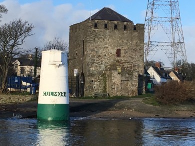
The light at Culmore Point
Onwards we went to our first light in the River Foyle, Culmore Point. You can pretty much drive to Culmore Point, but I’m glad we saw it from the boat as it wouldn’t have been half as nice to see from the land. The tide was in at the time so half of the lighthouse (the half with its name on would not have been accessible anyway from the land). Unfortunately, someone had decided to “decorate” the tower with a large drawing, the details of which I won’t go into (Richard suggested PhotoShop might be in order, let’s just leave it at that). It’s not the most fascinating of lights, but it marked the beginning of a sort of style of lights that litter the River Foyle between its entrance and the bridge.
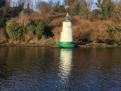
Ballynagard
Ballynagard was the next light, just a short distance away, that bore a resemblance to the Culmore light, although it didn’t bear its name – or the graffiti come to think of it. This one appears to be a bit harder to access from land, so we definitely went the right way about it.
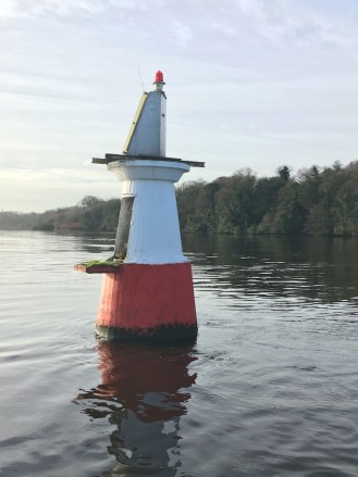
The Otter Bank light
The next one was a major target for me. I had seen pictures of Otter Bank online and, in order to qualify for my list of lighthouse the structure must be able to be accessed internally. From what I had seen it was difficult to tell whether it was possible to get inside this tower. So, the key priority for the day was to try and work this out. The only problem with this was that the side on which there is a small platform with what looked sort of like a door opening was surrounded by shallow water. Fortunately, Richard is a particularly skilled skipper and managed to slowly edge around the tower while Bob crept on to the front of the boat to get as close to the side we needed to see as possible. I, of course, stood back like the queen and watched. Actually I didn’t really. I did try to get a look myself, but it was Bob’s pictures that helped me to make the final decision that, yes, it is possible to get inside. It may not lead anywhere now, but you can definitely get inside. I referred to it as the equivalent of a lighthouse bus shelter!
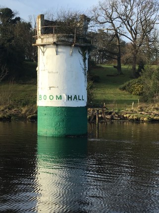
Boom Hall
Feeling very pleased and thinking that was us done in terms of what I needed to achieve in the Foyle, Richard suggested we go up river a little further as there were some more lights before the bridge. We passed the Brookhall light, which I knew had no internal access and this was reconfirmed. Onwards we went and as we got closer to the bridge we spotted a tower that looked fairly substantial. This tower, like Culmore, featured its name: Boom Hall. This one hadn’t even been on my radar and for the rest of the day we would call it the “unexpected lighthouse in the bagging area”. The tower had clearly not been operational for some time. It has what looks like a tree growing out of the top and the small walkway/jetty that used to link it to the river bank has long since gone leaving just the old iron legs that supported it. Interestingly, there is very little information available about this light, apart from an old picture here. The name “Boom” may well come from the fact that this part of the river was the location of the boom barrier put in place by King James II’s army during the Siege of Derry in the 17th century. Most likely though is that it was built around the same time as the nearby Boom Hall (presumably that took its name from the boom barrier). Boom Hall is also in a particularly bad state of repair. So, this was a new one for me and I was very glad that Richard had suggested going a little further.
On the way back to Coleraine, once we’d passed through the wild entrance to the River Bann again, we stopped for a little to look at the leading lights a short distance from the river mouth. I had been aware of them and we’d spotted them on the way out, but I wasn’t sure whether either of them would fulfil the criteria required for making my list. Although the views from the boat weren’t able to answer that it did give us an idea of the surrounding area and how it might be best to access them. Richard suggested walking around from the beach might be the quickest way.
River Bann Leading Lights Front
Saying farewell and thanks to Richard who had been so accommodating of my requirements and requests (and hadn’t looked at me strangely once when I was talking about getting inside these small lighthouses – very grateful for that), we set off as fast as we could for Castlerock as we were losing light by the minute and wanted to get to the leading lights while we could still see our way there. We’d been out on the boat a lot longer than we’d thought we would be and so lunch had been skipped, there were more pressing matters to deal with. We found the beach and it was an easy walk across the sand and then the dunes to the front of the two lights, which I was delighted to find had a door! It looks a little like it might fall apart at some stage, but it would still be possible to get inside it, if you had the right equipment, of course. I was fairly certain that if this one had a door then the rear would.
River Bann Leading Lights Rear
The rear light wasn’t too far away and the route we took was nowhere near as foliage-filled as we had feared. It’s entirely different, structurally to the front light, and was easy enough to find. (Note to my friend John who will read this at some point: it’s very close to the 5th tee of Castlerock golf course when you get around to starting on the Irish lights!!) I was adamant that I should be the one to see if it had access inside first so the mountain goat (sorry, I mean Bob) waited patiently while I slid around to the back and peered in. It was one of those moments when you want to look, but you don’t just in case there is something out of a horror film waiting to jump out at you. So I looked far enough around to see that you could get inside (the remains of the door lay on the ground nearby) and then Bob took over and braved it. I did look in the end, once it was confirmed that the coast was indeed clear. There wasn’t really much to see at all, apart from a cable – you know you are scraping the barrel when all you can mention is a cable!
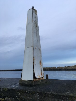
The Portstewart light
We didn’t hang around for too long as there was still one more light to be seen while we were in the area. It was getting darker by the time we got back to the car, but it would have annoyed me too much to have left one single light to visit in the area when we were so close. So, Portstewart it was. As I suspected it was easy enough to find. It’s a funny little thing. Like a little kiosk where you might get ice cream on a summer’s day, except it has a rather intriguing light on top. I can’t really explain it so well, so will include a picture to show you instead.
So, that was the end of a very busy, lighthouse-filled, lunch-free day! It’s great to be back in Northern Ireland and nice to spend some time in some new parts too. More tomorrow 🙂
So, eagle-eyed followers of my blog will recall that my last post claimed to be the final one for the year. It turns out that wasn’t quite right, which I suspected at the time might be the case, such is the way when opportunities seem to arise out of the undergrowth, even at this time of year.
For a few years now we’ve had our names on a list to go on a winter trip to Bass Rock at the entrance to the Firth of Forth. Every winter the organiser, Alan, would be very helpfully communicating with the boatman and sending emails every couple of weeks with new potential dates and each time it would come back with the instruction “Stand down”. However, last year Bob got lucky and managed to be around for the trip out on the Braveheart from North Berwick. With a four-month-old baby at the time, I was the one who stayed at home, but with the promise that I would still get there, one day.
Fast forward a year and, again the emails were coming and then the disappointing messages would follow. A couple of weeks ago we were about to pack our bags when a second email confirmed that, contrary to the first message, the trip was in fact cancelled. When you do these things frequently you accept that sometimes conditions change. That’s just the way of it. You can’t control it, so you just go with it as and when you can.
Well, the email came through at the weekend to say that while Tuesday was not an option, Thursday might be. We had an “amber light” on Monday and then again on Tuesday. Final confirmation was to come at 6pm on Wednesday. Of course, living as far from North Berwick as we do, I needed time to get there. So, after work on Wednesday I continued down the road to Inverness and waited for news to come at 6pm, which it did and it was a green light! So, I hopped onto a train bound for Edinburgh.
It was an early start in Edinburgh for me this morning to make sure I arrived in time for the boat. I am not at my best in the mornings, but I ended up quite pleased to have arrived in North Berwick while it was still dark. Not only could I see the light on Bass Rock flashing away, but the light on Fidra too. Most impressive of all was the Isle of May though. While both the Bass Rock and Fidra lights have been replaced with LEDs, the Isle of May light is still something that slightly resembles a rotating optic and was fabulous to see flashing brightly in the dark. As soon as the first sign of daylight emerged though the flash was significantly less visible. I strolled out to the end of the harbour which is a particularly good vantage point for seeing the three lights already mentioned. I also spotted one across the Firth of Forth, which (based on its location) was most likely to be that lovely little Elie Ness light.
I met up with the rest of the group and we set off. I must admit I was fairly confident that we would get landed as the sea conditions were calmer than the day we went out to Fidra earlier in the year. Bass Rock is an amazing island, very imposing and you can sense that even from a distance away. I had seen “the Bass” a number of times from North Berwick in various conditions, from perfect sunny afternoons to gloomy days when it was shrouded in mist or low cloud. It’s got a similar feel to Ailsa Craig. The approach to the island is awe-inspiring. Seeing that recognisable shape close up is pretty special. We slowed and sat back for a while as the crew had a look at the landing area. There was more swell that we’d be expecting, with the occasional wave from the east skirting around the base of the island. As soon as the skipper, Dougie, started giving advice on exactly when we should go and that he would do two at a time before pulling back and going in again, I began to wonder if landing might not be as straightforward as I had hoped.
I got in the queue and watched as the others flung a leg over the handrail , got a foot on the island when the boat has momentarily stopped lurching up and down, and were then – in some cases – partially dragged onto the island by the crew member on the steps. Having seen the height of the handrail and the speed the others had needed to move I decided not to risk it. I went back down to the skipper and then saw the last guy get off in a slightly more controlled manner and thought “maybe I can do this”. Once I got back to the front of the boat again I changed my mind though. It just was not going to happen. Had it not been for having to climb over the handrail and if it’d had a gap in the middle that I could have walked through then I would have absolutely gone for it. I’ve since spoken to Bob about the landing conditions today and he informed me that “It would have been fine, you just need the confidence and experience”. I have neither, and I’m certain I made the right decision. The skipper himself said it was marginal for landing today, which made me feel a bit better about my choice!
Anyway, not having to endure the stress of landing and getting back on the boat, I chatted away to Dougie while watching the lighthouse and the changing colours as the sun continued to rise. He sailed around to the east of the island to show me the alternative landing “for a laugh”. It was a very uninviting landing today! After that we took a spin around to the west of the island where he pointed out the cave (see picture below) that goes through the entire length of the island and, at low tide, it is possible to wade through. Interestingly, the water to the west of the island is very shallow, at only about 7 metres, while the depth at the east is more like 40. The geology is truly incredible and this is further enhanced on the south by the remains of the various buildings that have called Bass Rock their home, including the castle, which once operated as a prison.
Dougie clearly knows the rock and its history particularly well. He recalls there once being sheep and grass there, which is difficult to imagine now, but the gannets who insist on making it their home each year have destroyed that, as well as seeing away the puffins who used to nest there. Aside from the boat operators at the Seabird Centre in North Berwick, Dougie in the only boatman who has permission to land on Bass Rock, which he has obviously done a number of times. He described the state of the old lighthouse buildings on a recent visit with the roof now threatening to fall in as a result of damp. There has also recently been a mudslide near the lighthouse, which has left a layer of deep mud across some of the path.
He has also dealt with Northern Lighthouse Board engineers a lot in the past. He recalled one time he took them out to the island in the morning to work on the light and returned at dusk to pick them up, but which time conditions had deteriorated considerably. Luckily they managed to get them off safely, but it sounded a bit hairy! He had also taken the engineers out to Inchkeith in 1986 when they were automating the lighthouse there and he spoke very fondly of his memories of looking around the keepers’ accommodation during those visits.
The topic of the yellow-ish paint that the Northern Lighthouse Board use on their lighthouses (I’ve heard recently that it is called “bamboo”) came up. He had a funny story about a local resident who was looking to paint the top of their wall, but didn’t have any paint for it. They had asked if anyone had any and a few massive cans of this bamboo paint appeared and shortly afterwards the wall may have every so slightly resembled a Northern Lighthouse Board shore station, or even lighthouse, wall. I imagine that happens fairly routinely where there is a lighthouse nearby.
By the time the others started heading back down to the landing point the blue sky had appeared and I was able to get some pictures of the lighthouse bathing in the golden sun with blue skies in the background. Sometimes these things happen and you think that maybe there is some force looking down on you thinking “Oh, let’s just send in some beautiful conditions, just for her, just for a few minutes.” It often happens when you don’t expect it, as was very much the case at Barra Head earlier this year.
You could tell Dougie wasn’t entirely looking forward to everyone getting back on the boat when he turned to me and said “This should be fun” as they were coming down the steps. Their return was thankfully straightforward with no men injured or overboard, and we set off back to North Berwick. I think we all appreciated the final close-up views of Bass Rock as we sailed away. It really is a magnificent island, even if the others were keen to clean their boots in puddles once we got back to the harbour! One of the guys told me he’d spotted some kind of liquid of various colours and he had no idea what it was. The island was also described as “aromatic” by another!
I may not have landed this time, but I’m not too disappointed. I had a fun morning and got to see the lighthouse much closer than I ever had before. Maybe I will need to join one of the tourist trips during the summer and just accept that I’m going to be surrounded by birds, as much as I dislike the thought. A good day today though, and definitely worth the effort, even if it was just to get a closer view.
I won’t say that this will be my last post for the year this time as it won’t be. Exciting plans lie ahead for one final bagging trip before 2018 is over. More to come on that in just over a week! 🙂
We made it onto the Clyde this morning with Greg and Ian from Seaforce. The purpose of the trip was to take in the four lighthouses between Renfrew and Dumbarton. While the Blythswood (Renfrew) and Donald’s Quay (near the north side of the Erskine Bridge) lights are accessible on foot, there were two less accessible: Dalmuir East and Dumbuck, hence why we chartered Seaforce’s RIB to get us to them.
Bob had suggested taking the kids and his mum with us for their first RIB ride, which seemed like a good idea, if a little more effort for us. Boat trips are very easy when you don’t need to worry about small people. When they come along you’re obviously worrying about their warmth, safety and whether or not they might just kick off at any moment.
The conditions couldn’t have been much better today, taking into consideration the fact that it is November. The river was nice and calm so balancing clinging onto the kids with trying to stay in the boat ourselves wasn’t such a problem. Bob had offered to be photographer as our one-year-old daughter is still hesitant to put me down after our recent periods away from them. While the boat was moving Bob held onto our four-year-old who he could temporarily let go of while the boat was stationary.
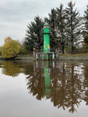
Dalmuir East lighthouse
The first lighthouse we reached was Blythswood. This light can be seen from the coastal path north of Renfrew, so not so difficult to get to. The river has a plethora of mainly green, but also, red lights and markers. Blythswood is green and is the only one in this section of the Clyde that looks like a traditional lighthouse. It has a band of graffiti on the lower section of the tower, which is a shame, but seems common on the accessible Clyde lights. Not only was the water calm today, but it was a little overcast making it an ideal day for reflections in the water. Blythswood stands on the edge of a tree-lined path and reflections of Autumn trees in water is always beautiful.
We continued on to Dalmuir East. This had been a troublesome one. It is located just at the edge of an industrial area with what appeared to be no access at all to the site. So there was only one way to see it! This one is smaller in size than some of the others along the Clyde, but many of those have external ladder access only whereas Dalmuir East has internal access. The lack of graffiti on it is probably a sign that it’s not possible to reach on foot.
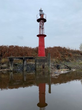
Donald’s Quay lighthouse
Donald’s Quay, on the north bank of the Clyde next to the Erskine Bridge, was our third lighthouse of the trip. This one is easy enough to access, but while we were passing we thought it would be rude not to stop. This one is almost identical to the Dalmuir light, except it has a stone base, making it appear slightly more substantial. It was nice to sail under the Erskine Bridge too.
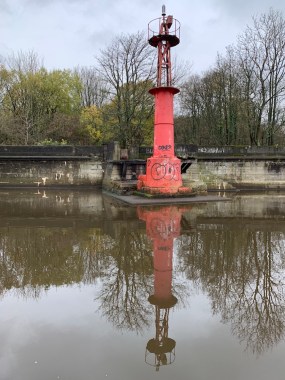
Our final stop of the day was at Dumbuck. Last Thursday we had stopped briefly near Dumbarton Castle to see it from the shore. It offers a distant view, but it is only when close up to the tower that you see that the structure is much larger than it’s various neighbouring lights and markers. On the upper stone section you can see the old windows, the majority of which are now broken. Greg informed us that there was previously a lantern on top, but this collapsed around the year 2001. There is a picture of the collapsed lantern here. We were pleased it was high tide while we were out as it meant we could get closer to the lights than we would otherwise have been able to. It’s a shame that the light has fallen into disrepair, but that is the often the problem with these structures located in or close to the sea that are so open to the elements.
Dumbuck lighthouse
That was it for our hour on the Clyde today. We are looking to organise a trip with Seaforce next year to head out to Loch Long and Loch Fyne to see a few of the inaccessible by land lights out there. They were really helpful guys and weren’t fazed at all by the kids coming along (they both came along as a result of us taking children – it may have just been one of them if it had just been the two of us). The kids were well-behaved thankfully. The youngest fell asleep and the eldest really enjoyed the “fast boat”.
So, this may well be the last post of the year, which isn’t bad going seeing as it’s already November. This has been the longest “bagging season” since 2012 and absolutely the best year so far. I’ve seen lighthouses I had been waiting a long time to see, discovered plenty of new places and met some wonderful people and new friends through my more active involvement with the Association of Lighthouse Keepers.
Plans are already afoot for some very exciting trips next year already, the thought of which should keep me going through the winter. For now though it’s time for me to go into hibernation in terms of visiting lighthouses, and save some money too (for next year’s trips, so the boss says). Thank you so much to those of you who continue or have started to follow my blog this year. I hope you have enjoyed reading it as much as I enjoy writing it. If it has helped, inspired or encouraged you in any way then it is doing exactly what I intend it to. Until next year… 🙂
Today was the last official day of the mad plan (we do now have the Clyde trip organised for tomorrow), but it was also the day where the mad plan caught up with me. It has indeed been a mad week: eight ferries, one boat trip, four flights, and – most importantly – over 20 lighthouses not including the distance bags. No wonder I’m tired.
Anyway, another factor contributing to my tiredness today was Bob’s insistence that we get the 7.10am ferry across to Whalsay. I obviously didn’t mind visiting the lighthouses, but did it have to be so early a start! His reasoning was that it would then allow us time to visit some more on Mainland Shetland before flying back to Aberdeen. How could I argue?! So, a 5.20am alarm call it was.
Off we set in the dark (I know, there are so many things wrong with this) and made the first ferry. Due to the irrepressible southerly winds we have experienced in Shetland over the last couple of days the ferry was departing from Vidlin, which meant a potential sighting of the light on Wether Holm on the way to Whalsay. Sadly, this was not to be as the ferry took a different route. The crossing was a little splashy in places, but not too bad. Not only did we have an early start, but our time was restricted on the island to 1 hour and 25 minutes (not by ferries necessarily, but by Bob – the man is relentless). So, 85 minutes to visit two lighthouses and hopefully allow him time to get to the island high point. Fortunately, Whalsay isn’t too big and the lighthouses aren’t too many miles apart.
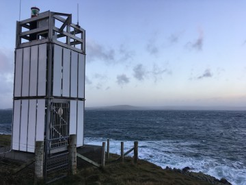
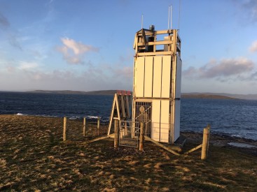
Symbister Ness lighthouse
Our first stop was Symbister Ness on the south west coast of the island. Brian had very helpfully informed us that it was just on the other side of the quarry, which we skirted around. If anyone reading this is thinking that Bob is cruel then you’ll be pleased to know that he got wet feet on the way to the lighthouse (mine are still dry)! It was quite wet underfoot in places, but in general was straightforward. The lighthouse is one of the delightful IKEA types, which replaced a more traditional looking structure (more on the original a bit later). It was a nice vantage point for watching the waves crashing on the smaller islands in the area and on the rocks just below the lighthouse. Having spent just long enough there to take some pictures, we needed to return to the car in order to stick to the schedule.
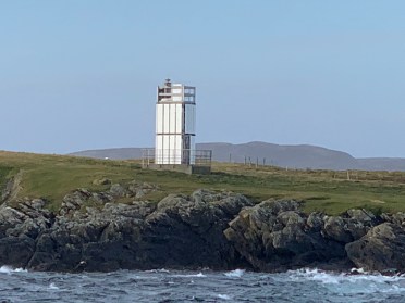
Suther Ness lighthouse
Suther Ness was our next destination. Again, Brian had offered his advice on where to park and we made sure not to leave the car in anybody’s way. Suther Ness sits in a stunning location, similar to Ness of Sound on Yell, on a small almost-island that is connected to Whalsay by a narrow strip of land. The sun was rising as we walked out to the lighthouse and who can resist that golden glow? We could also see the light on Wether Holm from here so we felt we hadn’t entirely missed out on that one. The original lighthouse at Suther Ness now stands in the car park outside the Museum of Scottish Lighthouses in Fraserburgh. The team at the Museum are doing fabulous work to give a home to the disused lights and optics. The current tower at Suther Ness is also a flat-pack IKEA. After two days in Shetland I had not managed to see any of this type at close range, so felt the need to make up for it today!
Wether Holm lighthouse
Again, sticking to the schedule we dashed back to the car and I encouraged Bob to make an attempt on the island high point as he’s not got a lot out of the past week in terms of hills. That good wife move almost backfired though as he only had a very short period of time to bag the hill before we needed to get back to the ferry, which meant he had to rush, so perhaps not as enjoyable for him as it could have been. But he got the hill done and we made it back to the ferry and just about squeezed on. We were particularly pleased to find that the ferry was taking its usual route back to Vidlin, which would take us past Wether Holm. We got fairly close too, so a nice end to our very brief visit to the island. I imagine there is plenty more to see there, but the other attractions will need to wait for another time.
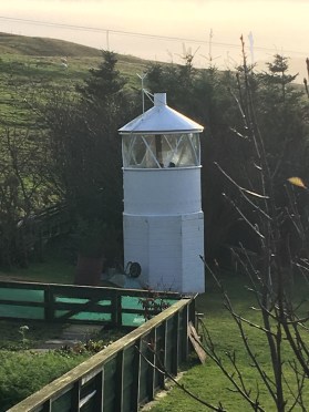
The old Symbister Ness lighthouse
I mentioned earlier the former lighthouse at Symbister Ness. Well, unlike the Suther Ness light, this one has ended up in a more unconventional location – in somebody’s garden in Collafirth on Shetland Mainland. We simply had to stop by and see it. It is very much out of place, but makes you smile when you see it. It felt a little weird taking pictures of someone’s garden, but I’m sure they must be used to it. I mean, you don’t put something like that in your garden and expect people to ignore it, surely! It’s great to see it as you head north on the main road. I have informed Bob that I would like one in our garden, so I shall eagerly await Christmas…
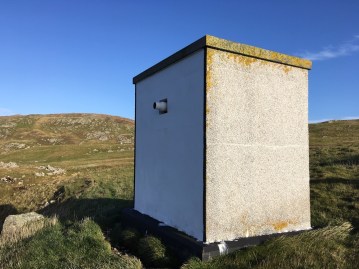
The main aim of the trip to Shetland was to gather some pictures of its lighthouses and we all know variety is the spice of life. I had seen very distant pictures of the two Shetland Council-owned lights in West Burrafirth. From a distance they just looked liked a box with a small light coming from them. I really knew very little about them, except that they were 2 metres tall so I suspected they had doors and were probably a bit more substantial than they appeared online. These lights would definitely offer the variety I required so we headed for West Burrafirth and the inner light first.
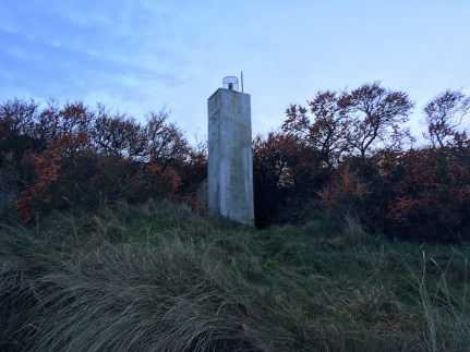
West Burrafirth inner light
Spotting it from the ferry terminal initially we then knew exactly where we had to go. It was a short walk to the lighthouse (Bob still managed to get his foot wet for the third time though) and I can confirm that it is indeed bigger than it looks. It’s still essentially a box with a light sticking out of it, but there’s more to it than that. Firstly, it is actually a building, roughcasting and everything! Secondly, the light is really quite interesting. If you look into the tube sticking out of the hole (I’m really selling it here, aren’t I?!) you can see the different sector colours. It’s all a little bit modern and you just never know it could revolutionise lighthouse technology in the future – probably not, but it’s a clever idea. I have decided to name this type a “light box” – it’s an affectionate term.
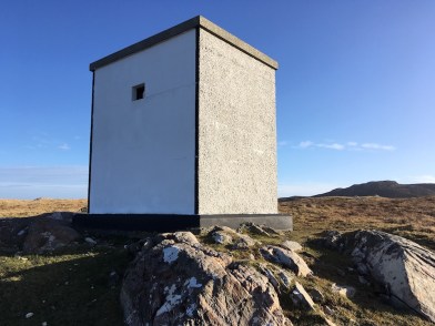
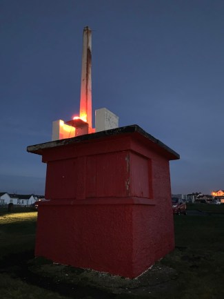
West Burrafirth outer light
I’m not going to say I enjoyed visiting the West Burrafirth outer light as much as that would be a lie. This was where my mood really went downhill. I can only blame lack of sleep and food and I have since apologised to Bob for his having to put up with me. Anyway, this walk was slightly longer with a bit more up and down, but we got there. You may be interested to know that this one is slightly different to the inner lighthouse. The light doesn’t stick out of the structure, it is set in slightly. The door also has a wider pane of glass! Really, there’s not much to say about them, but I can’t recall having seen any like this before.
It was finally time for a quick lunch and we decided, on the way south, to stop off at Port Arthur to check out access to the Point of the Pund light. We found the gate and start of the footpath, but decided we didn’t have time for the walk today, so we abandoned a visit. We’ll be back for that one, but good to get an idea of the starting point.
So that was really it for today and we are now back on the mainland. With it being such a clear evening we were able to clearly see Fair Isle and the islands of Orkney on the flight back. What a time we had on Shetland. It was exhausting, but so worth it. We achieved so much more than I expected and that is, in no small part, due to Brian. I must also mention Bob’s massive contribution to the trip: all of the miles of driving, the wet feet and putting up with me. Finally, thanks to Bob’s mum for having the kids and enabling us to have such a mad week.
One more post to come tomorrow following our Clyde trip and there is a chance that will be it for this year, but what a year it’s been! 🙂


 I met up with the rest of the group and we set off. I must admit I was fairly confident that we would get landed as the sea conditions were calmer than the day we went out to
  Anyway, not having to endure the stress of landing and getting back on the boat, I chatted away to Dougie while watching the lighthouse and the changing colours as the sun continued to rise. He sailed around to the east of the island to show me the alternative landing “for a laugh”. It was a very uninviting landing today! After that we took a spin around to the west of the island where he pointed out the cave (see picture below) that goes through the entire length of the island and, at low tide, it is possible to wade through. Interestingly, the water to the west of the island is very shallow, at only about 7 metres, while the depth at the east is more like 40. The geology is truly incredible and this is further enhanced on the south by the remains of the various buildings that have called Bass Rock their home, including the castle, which once operated as a prison.
 Dougie clearly knows the rock and its history particularly well. He recalls there once being sheep and grass there, which is difficult to imagine now, but the gannets who insist on making it their home each year have destroyed that, as well as seeing away the puffins who used to nest there. Aside from the boat operators at the Seabird Centre in North Berwick, Dougie in the only boatman who has permission to land on Bass Rock, which he has obviously done a number of times. He described the state of the old lighthouse buildings on a recent visit with the roof now threatening to fall in as a result of damp. There has also recently been a mudslide near the lighthouse, which has left a layer of deep mud across some of the path.
 The topic of the yellow-ish paint that the Northern Lighthouse Board use on their lighthouses (I’ve heard recently that it is called “bamboo”) came up. He had a funny story about a local resident who was looking to paint the top of their wall, but didn’t have any paint for it. They had asked if anyone had any and a few massive cans of this bamboo paint appeared and shortly afterwards the wall may have every so slightly resembled a Northern Lighthouse Board shore station, or even lighthouse, wall. I imagine that happens fairly routinely where there is a lighthouse nearby.
 You could tell Dougie wasn’t entirely looking forward to everyone getting back on the boat when he turned to me and said “This should be fun” as they were coming down the steps. Their return was thankfully straightforward with no men injured or overboard, and we set off back to North Berwick. I think we all appreciated the final close-up views of Bass Rock as we sailed away. It really is a magnificent island, even if the others were keen to clean their boots in puddles once we got back to the harbour! One of the guys told me he’d spotted some kind of liquid of various colours and he had no idea what it was. The island was also described as “aromatic” by another!