Success at Loch Eriboll

Loch Eriboll is not so far from where I live – relatively – and I have seen the little lighthouse numerous times from the other side of the loch, but only walked to it once. My first visit was back in 2012 (the very early days) alongside Bob who was navigator and, at one point, also gave me a piggy back to get across a particularly wet bit. I’ve mentioned my friend John, my new “flat-pack” partner in crime, in a few posts recently and in general conversation he mentioned that he would like to walk out to the lighthouse on Loch Eriboll. Often he is content just to see these ones from a distance, but he felt the need to reach this one and asked if I would be happy to help him get there.

While this was a simple request which I happily agreed to, it was also going to be the first time since I met Bob that I would be responsible for walking anywhere “off piste” and  guiding someone else on such terrain. I could tell Bob wasn’t entirely convinced that we wouldn’t end up in the middle of a bog or getting completely lost and abandoning the attempt. I saw it as a challenge and a way to prove that I could do it.

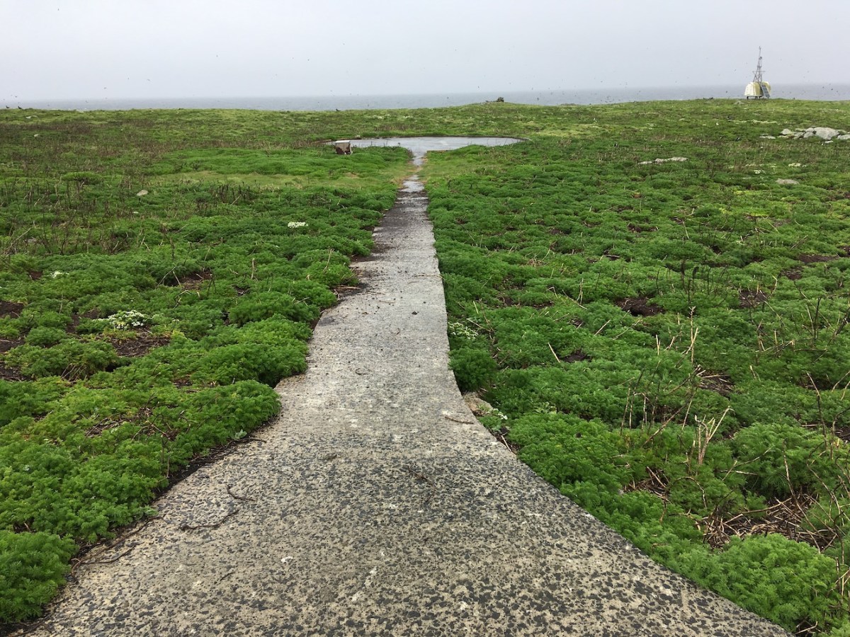
Fortunately, Bob lent me his GPS device and John appeared to trust me to get him there and back, so that was a good start. It’s not a particularly difficult walk with numerous obstacles, it’s really just making sure you go the right way around lochs and small hills. The ground underfoot is considerably easier than it was on some of the islands we walked on during the recent West Coast Adventure.

loch eriboll walk
The view from the start of the walk

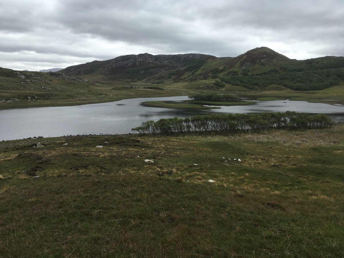
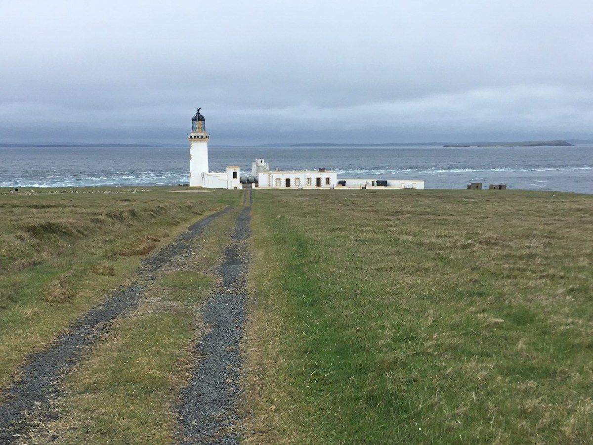
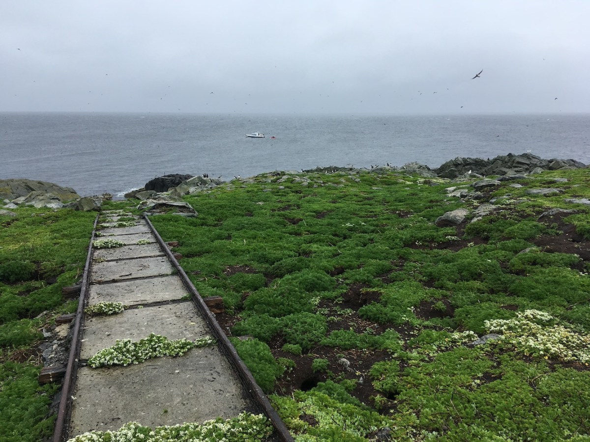
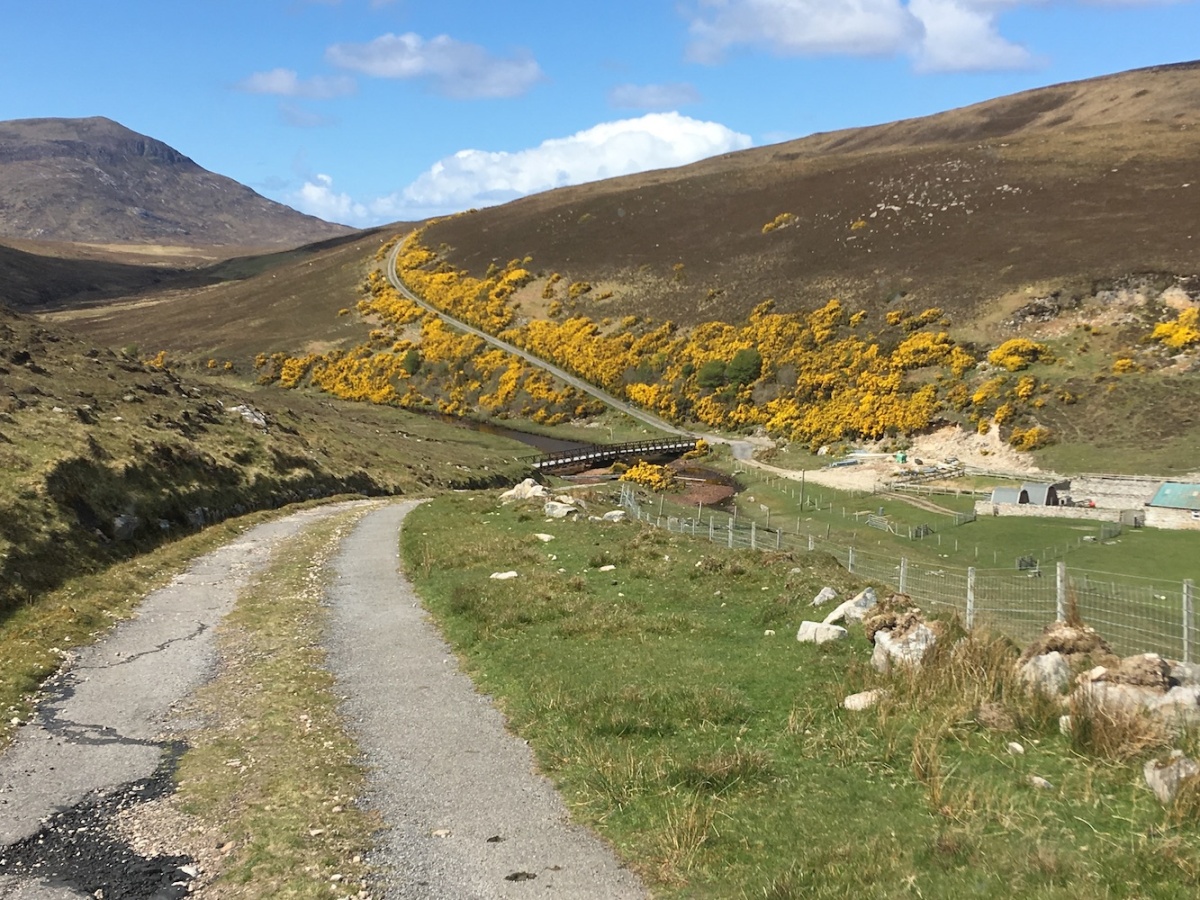
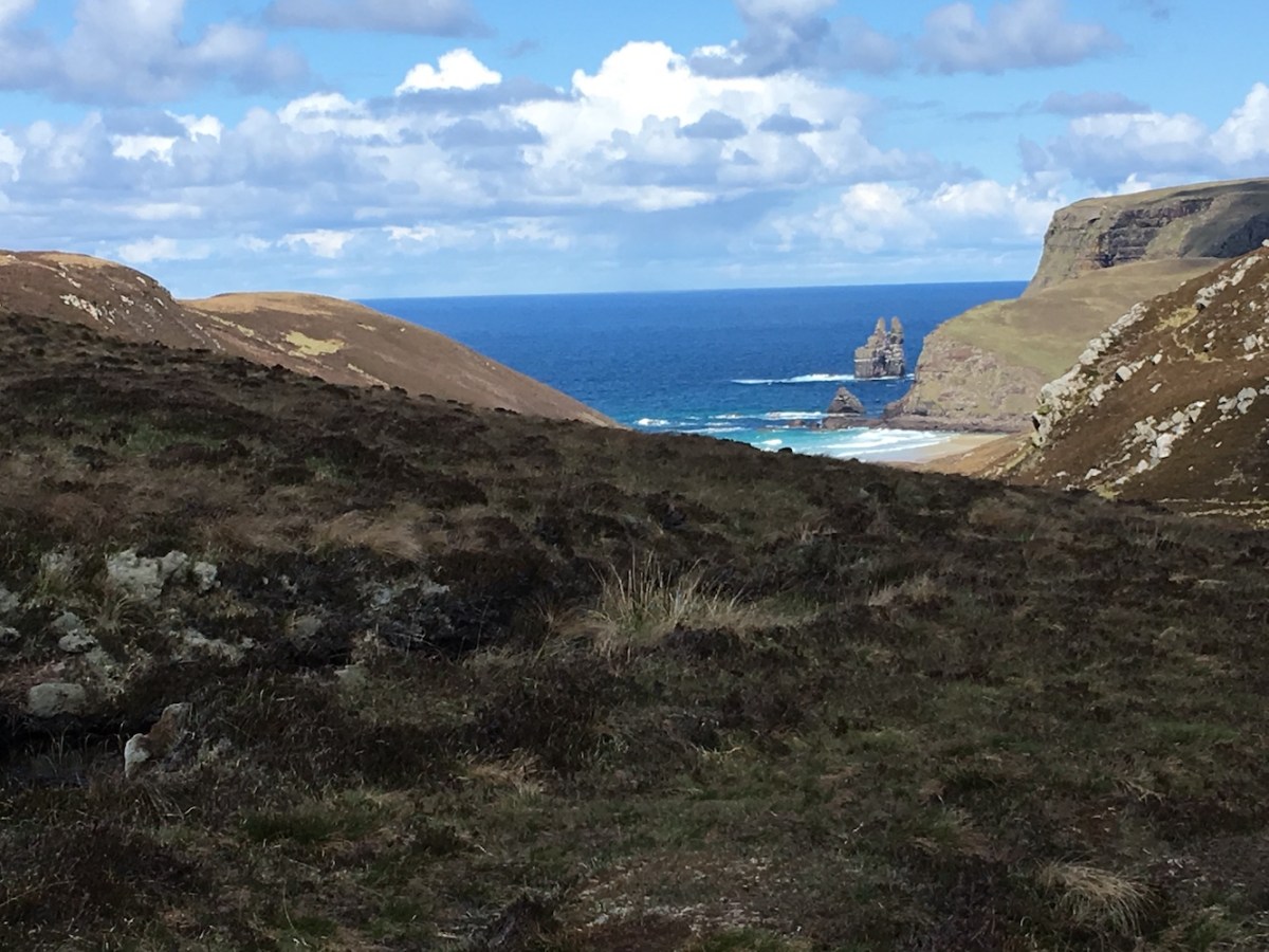
I found the parking area we had used previously and off we went. Immediately you are surrounded by some great scenery with a small loch and the slight hilly terrain beyond. Crossing a small stream was made much easier by John throwing a big stone into the middle of it to use as a stepping stone – this became known as ‘Sarah’s Bridge’. A short distance into the walk I perfectly demonstrated how “good” I am at judging land height from the GPS device by suggesting we walk uphill to the highest point we could see, on the basis that we would probably see the lighthouse from there. It didn’t quite work out as a little further on was another, higher hill. Fortunately, between us, we chose the best way to go around the next hill and it wasn’t long until we then spotted the top of the tower and knew that we were on the right track.

loch eriboll
A view of Loch Eriboll

Not so long before we reached the lighthouse we passed the remains of an old stone house with a few trees nearby. It must have been a wonderful place to live, although not so easy to access – and fairly small inside once you saw the thickness of the stone walls. Although it wasn’t the clearest day with rain threatening to start at any moment, there were still some great views of the loch.

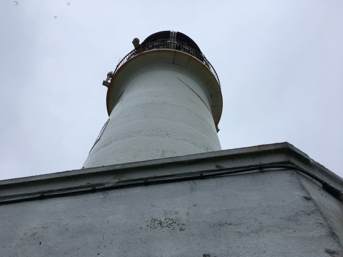
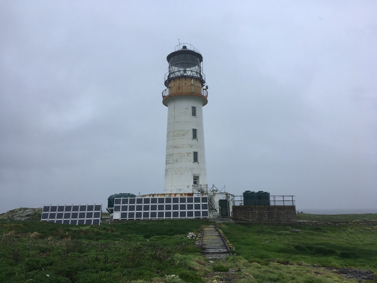
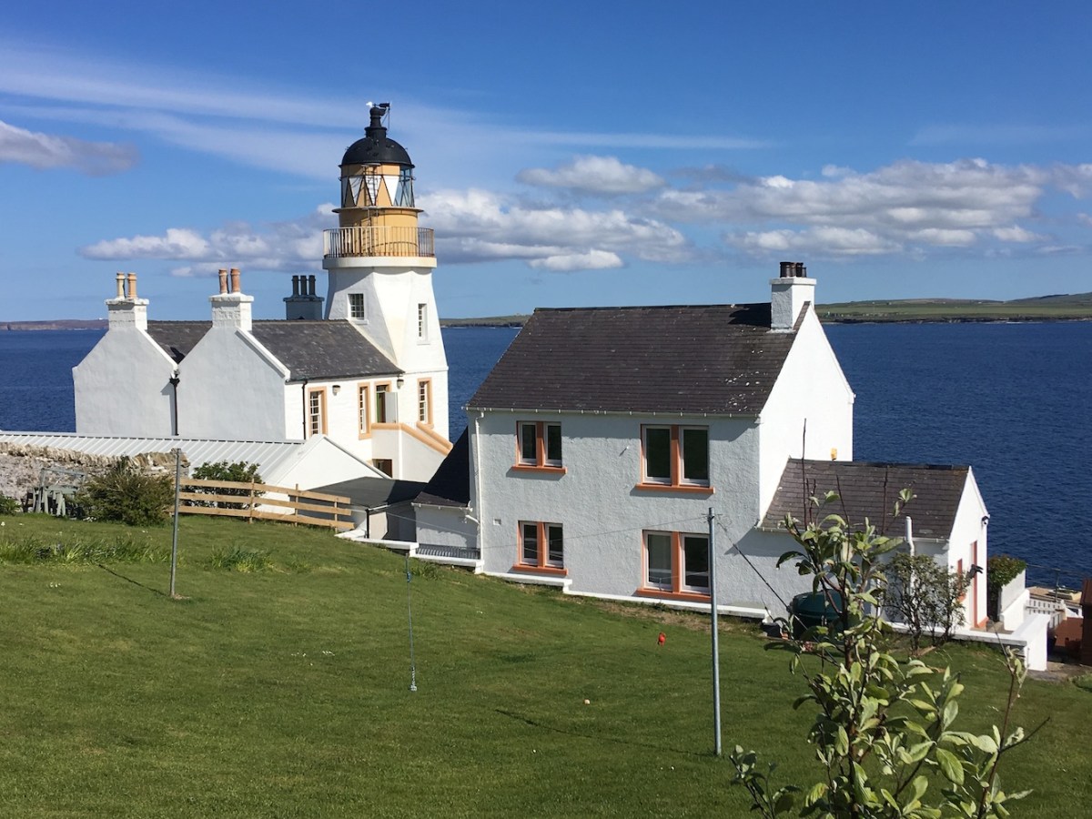
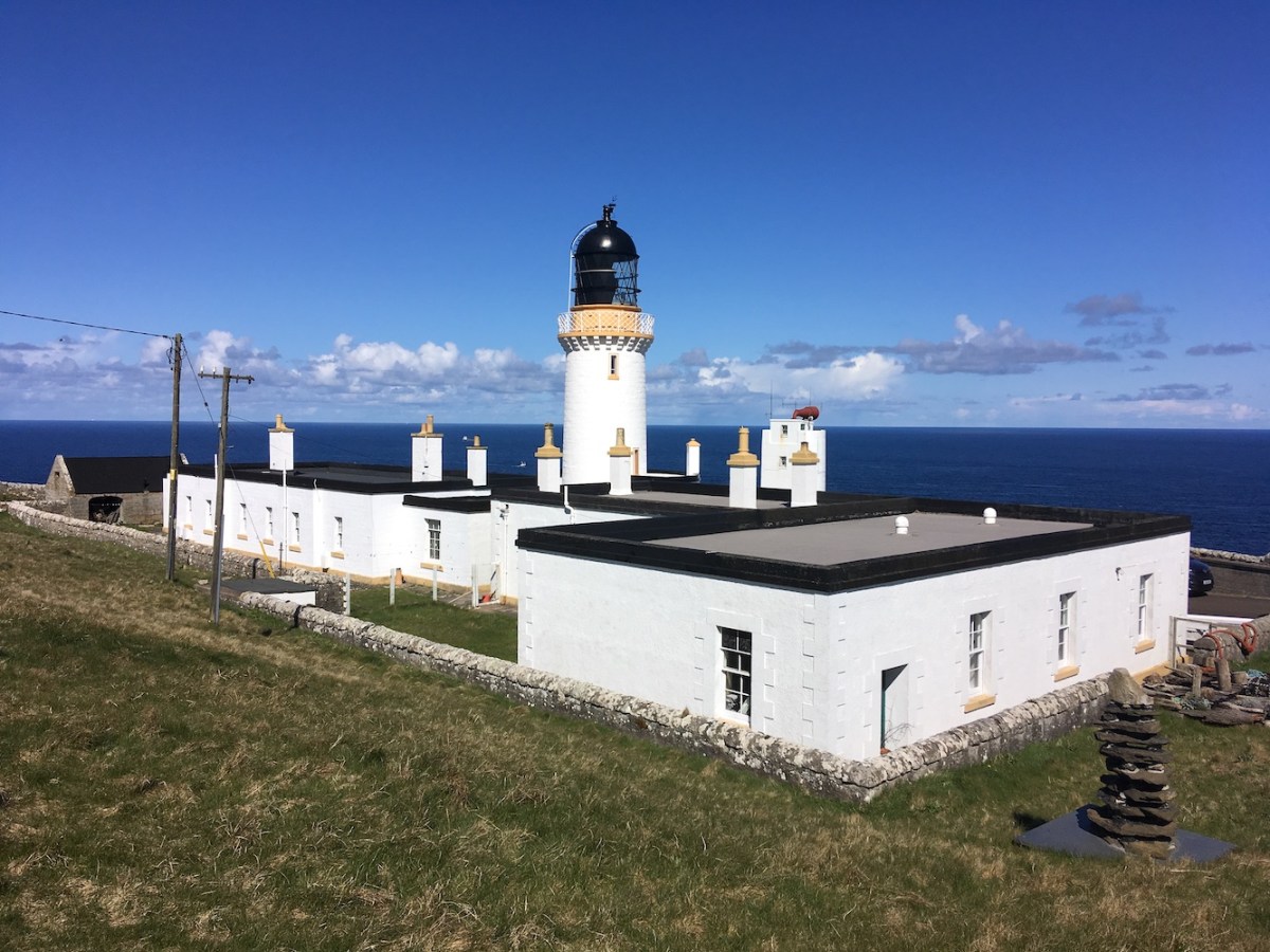
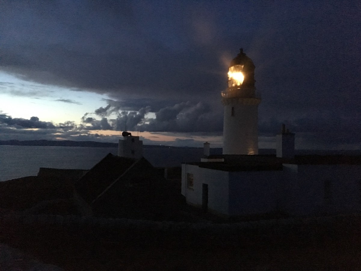
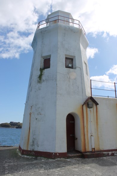
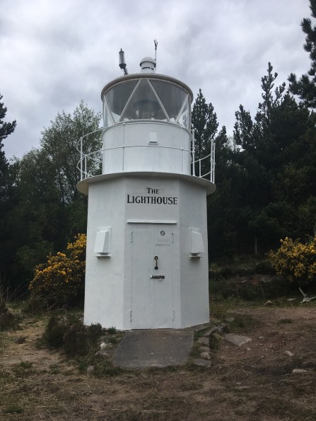
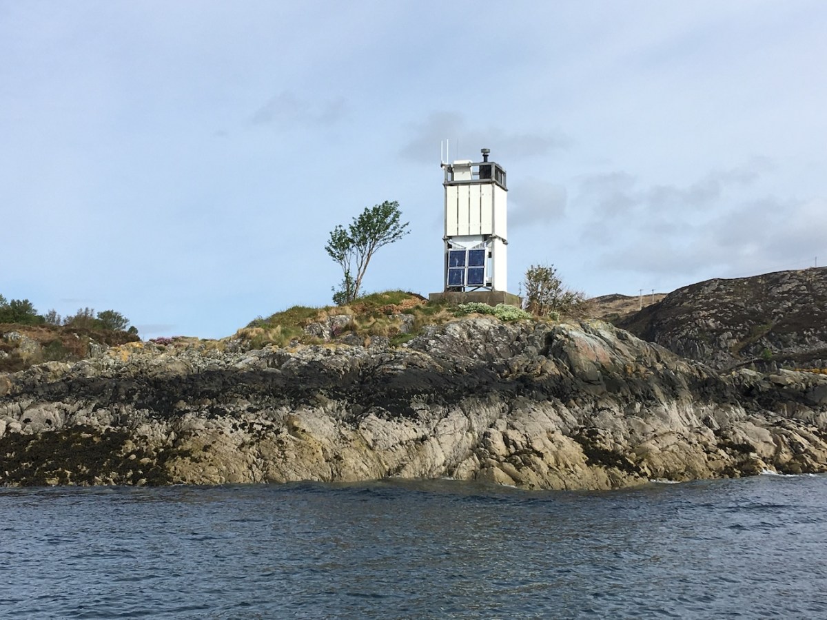
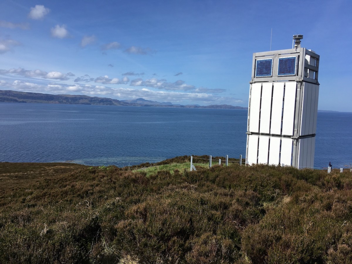
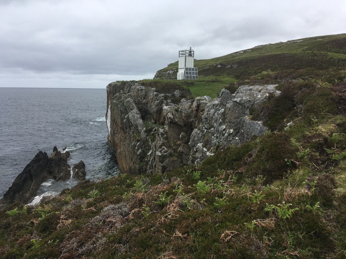
Success arrived in the form of a flat-pack lighthouse. I was pleased that we had made it and John was delighted to be there. It felt like a long time ago that I’d last been so close to it and it made me think about just how much I had achieved in lighthouse terms since my first visit. The Loch Eriboll light was actually my first flat-pack lighthouse so I am rather fond of it.

loch eriboll lh1
On the approach to the lighthouse

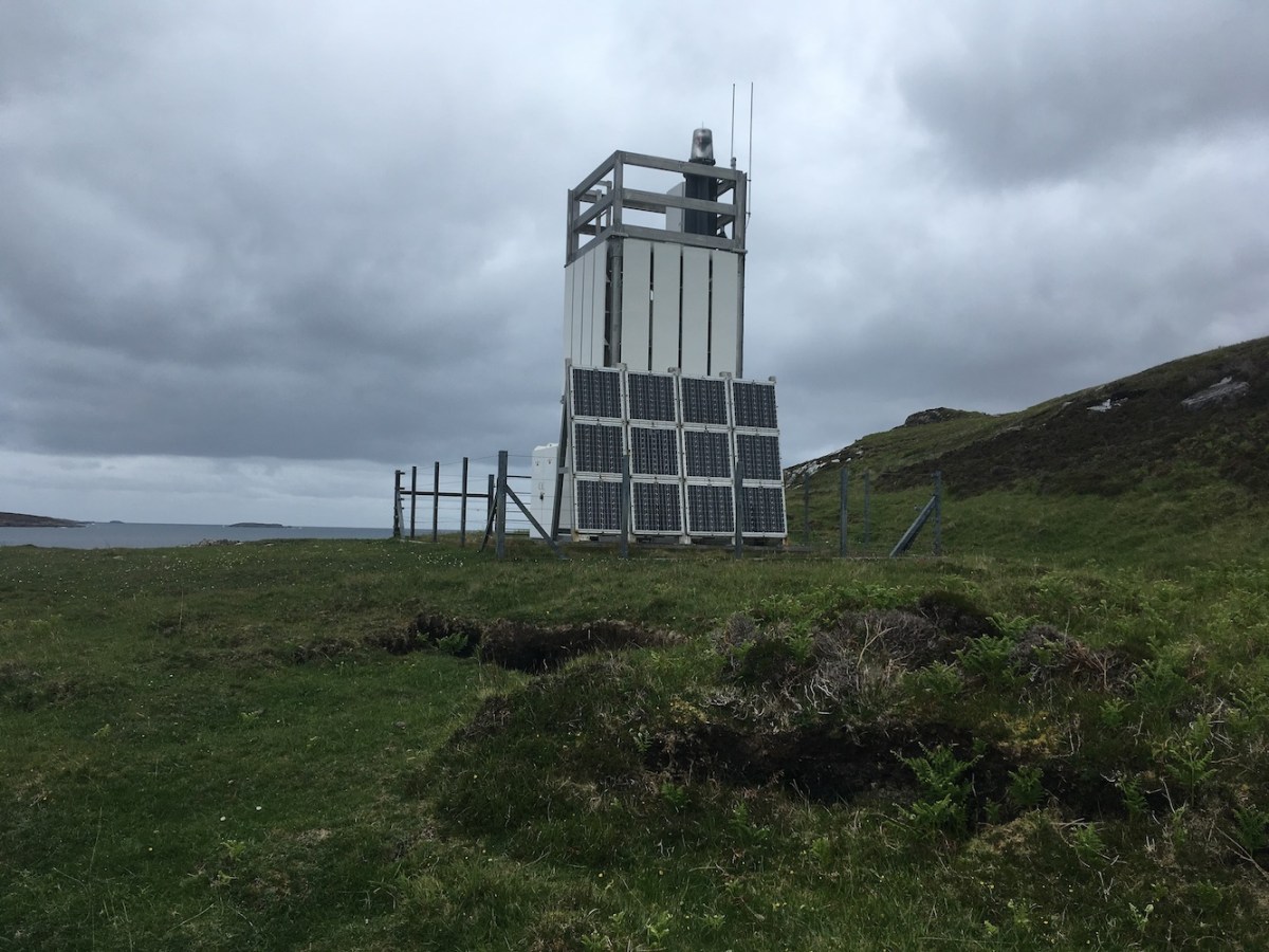
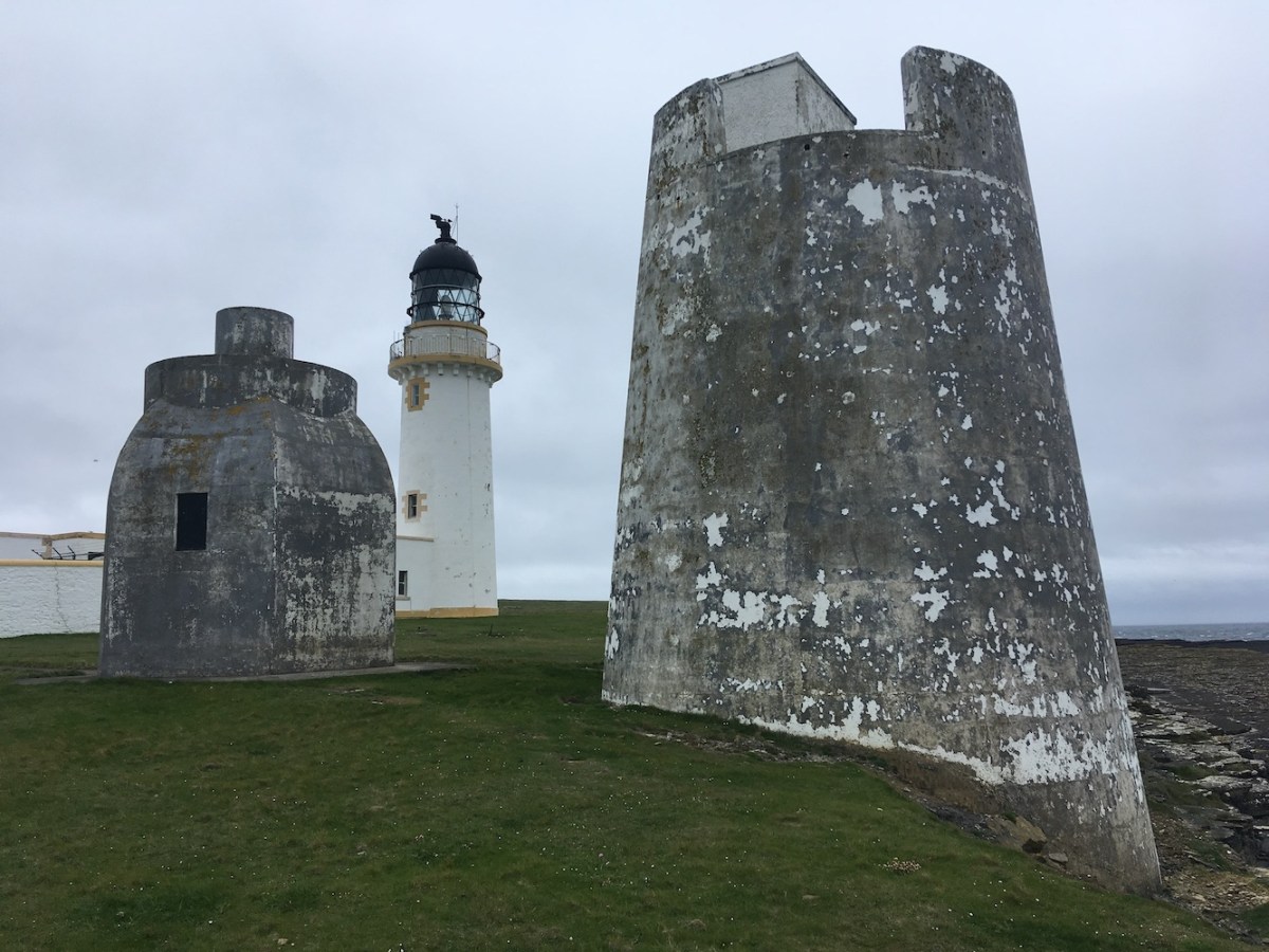
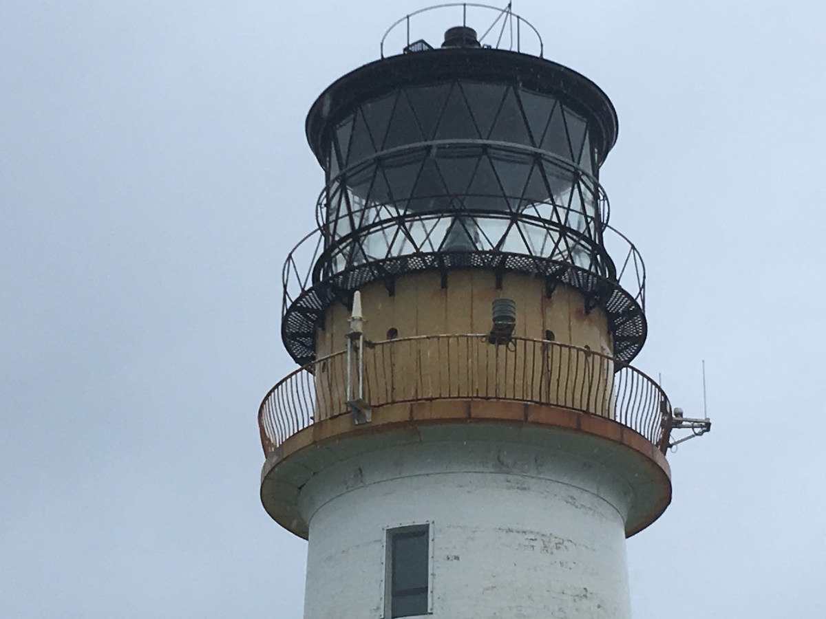
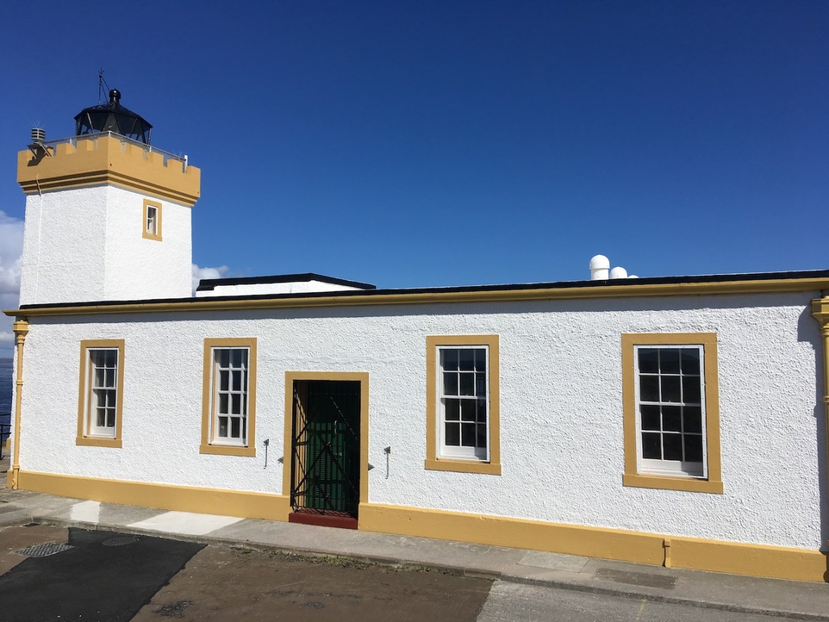
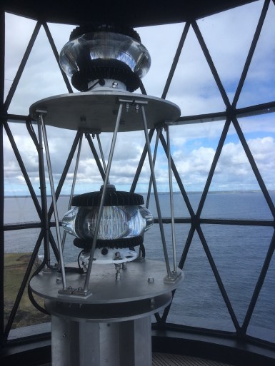
We wandered around the lighthouse for a while, both wondering how it was serviced as there appeared to be no obvious landing point for a boat nearby and no area of ground flat and big enough to land a helicopter. There were a number of metal rings in rocks close to the lighthouse, but they didn’t seem to serve a boat-related purpose. I recalled when we were there before that Bob had gone down onto some rocks, but the drop down was a little steep and the land was wet from a couple of days of rain so we didn’t venture down there.

loch eriboll rocks
Looking down at the rocks close to the lighthouse

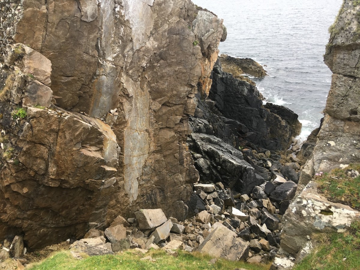
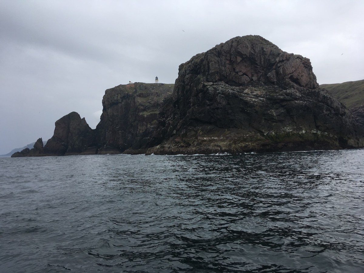
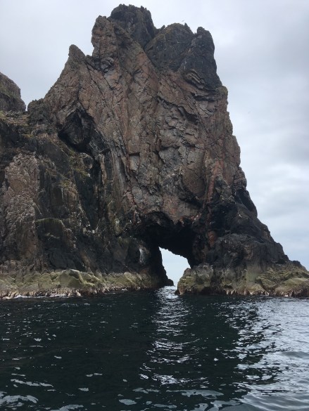
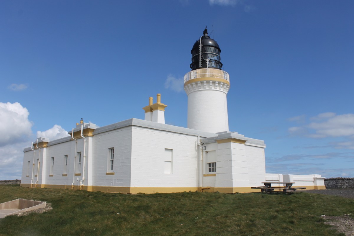
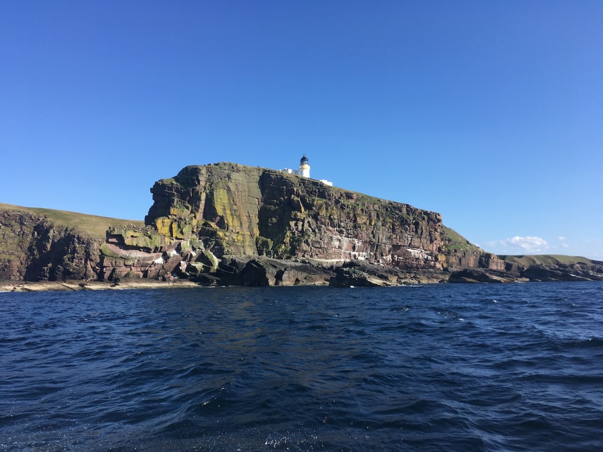
I’d not appreciated until recently how fascinating the coastline is in that area. I’ve recently watched an old STV series called Scotland: The Edge of the Land which features aerial footage of the coastline around Scotland and the land on the east coast of Loch Eriboll is stunning. I paid more attention to it, or what I could see if it, this time. One of the most distinguishing features of this lighthouse when you see it from the other side of the loch is the white stain on the rock below the lighthouse, which almost appears bigger than the light itself from a distance. Presumably this is from some form of lighthouse-related acid being poured over the cliff there. The lighthouse that previously stood in this location was one of the cast-iron structures (similar to those I’ve recently seen in Scoraig village and Glenelg), which would have required much more routine maintenance. John was keen to see this white staining while we were there, if it was possible to get a view of it. Light rain had started so we decided to head back, but I thought we’d check from one more angle to see if the mark would be visible and thankfully it was!

loch eriboll lh4
The angle from which you can see the staining on the rocks

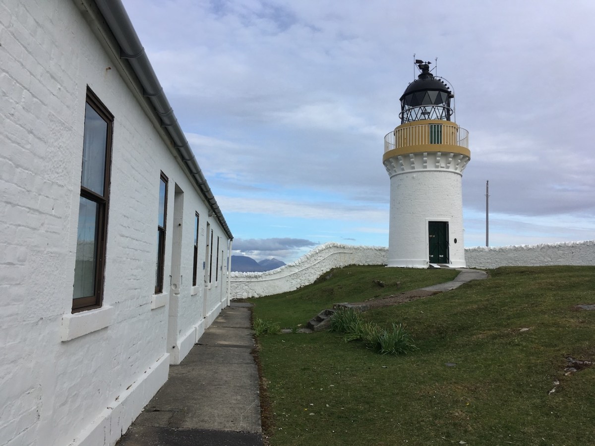
I often wonder how there came to be a lighthouse on Loch Eriboll. To me it didn’t seem like a natural place for the Northern Lighthouse Board, a national organisation, to put one as so many of their lights are in locations that guide ships through seas, into large river mouths or through frequently used channels. I’d looked into it a bit more recently as it really was intriguing me. The original lighthouse was built in 1937 and was designed by David A Stevenson, the last in line of the “lighthouse Stevensons”. I found out that the loch, being the only deep water sea loch, was (and still is) used as a place of refuge for any ship looking for calmer water to retreat to in difficult conditions to the east of Cape Wrath.

loch eriboll2
The view of Loch Eriboll looking south from the lighthouse

I also discovered that it was used by submarines during this Second World War, but it was built 2 years before the War began so that didn’t really explain the reasoning behind it. The only evidence I have found, through a brief search, of any disaster occurring in Loch Eriboll was the collision between the HMS Vulture II trawler and the minesweeper ST Phrontis FD142 on 16th March 1918. HMS Vulture now lies at the bottom of the loch, though thankfully there was no loss of life during the incident. I have found through recent research that often the loss of military vessels has led to the introduction of a lighthouse in certain areas. Whether this was the case here is unclear, particularly as it was almost 20 years between the collision and the building of the lighthouse. I think my research must certainly continue.

Although the walk out to the lighthouse wasn’t difficult, it was much easier on the way back and we were able to follow the same route by using some key “landmarks”. We made it back to the car in good time and I must admit I was pretty pleased with myself for my tour guide efforts, and of course John was too. I’m not sure how we would have got on without Bob’s GPS device though! A great couple of hours and well worth another revisit some time 🙂

Stroma with friends

Back in July 2015 I spent a few hours on the island of Stroma in the Pentland Firth. The blog post written about it was titled ‘Alone on an abandoned island’ as I joined the trip alongside a number of photographers whose target on the island was clearly very different to mine. This time I have called this post ‘Stroma with friends’ as I was most definitely in good company second time around. A number of my lighthouse friends were around this week for the fantastic Sule Skerry trip and they had all expressed an interest in getting across to Stroma if they possibly could. A few of them had tried to make it before on Association of Lighthouse Keepers trips to the North Coast, but had not managed for various reasons. After our trip to Sule Skerry on Tuesday the weather began to deteriorate and I spoke to the owner of the island that evening to find out what the likelihood of being able to get over there was. He asked if we minded a bit of rain and I, of course, said no. You can’t let rain stop you on these endeavours. He asked me to call back the following morning for a final decision. I must admit I wasn’t hopeful, but was pleasantly surprised when he asked us to be there for 10am on Wednesday morning.

We all gathered and hopped on board the Boy James at Gills Bay. It is only a short trip across to Stroma, but the Pentland Firth can be lethal. I’ve heard it said by too many boatman that it is very dangerous and you can certainly see, when crossing it, that it is a very disturbed stretch of water. Stroma, apparently, translates as ‘island in the stream’, which is something of an understatement when you discover that strength of the tidal races that run through the Pentland Firth, some of which are believed to have been running at up to 30km an hour. One of these tidal races is The Swilkie off of the northern point of Stroma, which gives the name of the point on which the lighthouse sits the name ‘Swilkie Point’. It seems that ‘Swilkie’ translated into Old Norse means ‘Swallower’, which is probably more representative of the hazardous tidal situation there.

Fortunately we made it safely over to the island, thanks to the great experience of the boatman who is also the island’s owner. He farms sheep on the island and has recently stayed over there for a month during lambing. I was interested to discover that he still has some lambs yet to be born, which I thought was quite late. It turns out that the reason they lamb so late (with pre-planning of course) is because it takes longer for the nice green grass to grow on Stroma and, as a result, the good quality milk produced by the ewes doesn’t come in until later than in many other places.

Stroma lh2
On the approach to Stroma lighthouse

Once we were on the island we had just over 3 and a half hours to explore. Of course the priority was the lighthouse so we set off, deciding that we would do anything else we wanted to see on the way back. I recalled it well from my first visit, not that it is a particularly difficult place to navigate around, but it was all very memorable to me, which can’t be said for all of the islands I have been to.

On the way to the lighthouse we could see the two towers on the island of Muckle Skerry, the largest of the Pentland Skerries, basking in sunlight as well as Cantick Head on Orkney and the beacon on the neighbouring island of Swona. Watching those lights come on at night must be wonderful to see from Stroma.

It didn’t take us long to arrive at the lighthouse. From a distance the lighthouse looks very similar to many others, but there are a number of small features that stand out. I was surprised by just how many gates they had going into the main compound and there were some small decorative touches that are often a good indication of a Stevenson-designed lighthouse. The presence of the old foghorn building as well as another oddly-shaped tower adds even more interest to the area. It is reported that the old 4th Order lens from Sule Skerry (not the original hyper-radial lens) was transferred to Stroma for use as the lighthouse was undergoing automation in 1996. The current tower on Stroma is actually believed to have replaced an earlier, non Northern Lighthouse Board, lighthouse of which there are no remains. Clearly attempts were made to address the hazards of Swilkie Point before it was brought up on a national level.

Stroma lh and towers
Stroma lighthouse with the old foghorn tower

The hazards in the area had not been limited to the sea though as a plaque on the side of the lighthouse honours the memory of John Calder an Assistant Lighthouse Keeper who fell to his death from the tower on 22nd April 1910. The plaque was placed on the tower by his family in 2010, 100 years after his death.

After we felt satisfied that we’d spent enough time at the lighthouse, we walked back up the path. We’d all spotted a building on the east coast of the island on the way to the lighthouse, which had drawn our attention due to the Northern Lighthouse Board colours, white and bamboo/biscuit/buff (apparently all the same colour, but it depends which supplier you get it from). We took a stroll down there. There was not a lot to see in the building itself, but just to the south of the building was an old pier and slipway with a rather rusty boat looking ready to be lowered into the sea at the top of the slipway. While I say the pier was old, it is in very good condition and the plaque part way along explains that it was build by the local community. It reads “1900. The foundation stone of this pier was laid by Mrs Carrow on 4th August” and lists members of the local pier committee. Clearly not much happens here these days with the fantastic harbour arrangement at the south of the island now, but it’s a great area to explore.

Stroma old boat
The old boat at the top of the slipway

We passed the War Memorial on the way back, which is a beautiful piece of art made up of stones of various shapes and sizes. Considering Stroma is only a small island, the memorial features a lot of names. Both wars must have been a real blow to the community on the island. It is yet another reminder of how close the community must have been before the last residents left in 1962.

Stroma wm
Stroma’s War Memorial

Stroma does feel remote, although you are not far from mainland Caithness. There is a similar feel on a number of abandoned islands. Aside from St Kilda, a lot of these places weren’t so far away, but still have a sense of isolation, but certainly not a bad one.

The weather had been kind to us until we were making our way back to the harbour and by that time the wind and rain was on our backs. We arrived back at the harbour just before the owner did and we all hopped on board the boat back to the mainland, waving a fond farewell to the island.

Last time I had been over I was not aware of having sailed close to the beacon off of the south coast of the island, but we certainly did on the way back this time. I imagine it was to enable us to work best with the current. It was nice to see the beacon from a lot closer, although I discovered later that evening when I got back home and showed my picture to Bob that the beacon must have changed since 2015. Below are two pictures, before and after, to illustrate the change.

Stroma beacon old
The beacon in 2015
Stroma beacon
The beacon as it is today

Another fantastic day on Stroma and one that has actually made me even more desperate to visit again to explore even more of the island. A really wonderful place 🙂

Sule Skerry: a birthday location

Living on the north coast of Scotland there is one lighthouse that, relatively, seems so close and yet so far away. For years I have been aware of Sule Skerry, which lies around 35+ miles north of the north coast and 40 miles west of Orkney. It is the most remote (formerly) manned lighthouse in Britain and has proven to be extremely difficult to get to. The only people I had known who had been there were Northern Lighthouse Board employees or guests – as well as my doctor who has previously been out with a bird-ringing group. Getting there was becoming a bit of a problem.

During a drive through Kylesku in August last year, Bob noticed a trailer advertising trips to North Rona and Sula Sgeir run by a company called North Coast Sea Tours. Those who regularly read my blog posts will know that we recently travelled north from Ballycastle in Northern Ireland to Kylesku in the north west Highlands of Scotland with North Coast Sea Tours. That trip was a result of our discussion with the skipper, Derek, about possibly getting out to Sule Skerry. Derek was happy to take us out there, weather permitting, and has since proven that there is very little he says ‘no’ to!

So, that was how we came to organise a week’s charter of the North Coast Sea Tours covered RIB in an attempt to get two groups (island-baggers and lighthouse-baggers) out to Sule Skerry. We chose the week of 20th May as it’s normally a fairly settled time of year, the tides times were right and my birthday fell on the Tuesday. Then we just had to hope for the best. The best clearly came on Monday when the island-baggers set off and arrived safely there within a couple of hours, travelling at a good speed most of the way. Bob was part of that group and when he got home that night and showed me the pictures my spirits rose at the thought that we may actually manage to land on the island too the following day.

Looking out of the window on Tuesday, which was incidentally my birthday, I saw there was significantly more wind than there had been the previous day and my spirits dropped a little. As we set off in the boat it soon became apparent that our good sea conditions luck was running out. It was an uncomfortable ride and about 30/45 minutes into the trip the skipper stopped and asked if we were willing to proceed, reassuring us that we would definitely be able to get out there, but that landing was very unlikely. I was disappointed, but we collectively agreed that we wanted to continue and if we had to settle for seeing it from the sea then we would do that. It was a long three-hour journey out there, but some of us settled into it after a while and there was great excitement as we approached the island and saw the tower. As we neared the island it became apparent that actually the landing areas were fairly sheltered. Derek asked for a few of us to go over to check out the landing area to see if getting onto the island was possible. I jumped at the chance to be in the first shuttle.

ss from sea
Sule Skerry lighthouse

We found a perfectly flat platform to land on and I gave a little shout “yes” once I was on the island. It was a pretty slippery landing area and the stone around the old tracks leading up the path were also slippery with some sections of the path broken over time. We made it to the lighthouse though, which was incredible. We had puffins just a short distance away to the left and, beyond the puffins, were a number of gannets. It is believed that these gannets have recently starting nesting on Sule Skerry after moving on from the nearby Sule Stack. We also spotted some bonxies as we reached the highest point of the island.

ss landing
Looking back towards the landing area

The lighthouse, although looking a little worse for wear in places, is beautiful. The look of the tower is very similar to the Flannan Isles lighthouse with the “oversized” lantern. While the lantern now only contains a very small light, when built in 1895 it had to accommodate a huge hyper-radial lens, hence the need for such a huge lantern. While these two towers (Sule Skerry and Flannans) don’t have the more elegant look of some of the others, I am a big fan of them. I think it helps that they are in very remote and beautiful places.

ss2
Sule Skerry’s oversized lantern

The shape of the buildings around the tower is really interesting. The tower rises up out of the middle of an octagonal building, which presumably was where the keepers’ accommodation would have been. In this way it is similar to some of the rock lighthouses, except the lower level of the tower is much wider. It’s certainly very compact. The tower itself also appears to have old bands on it. Whether this is related to the stone used to build it or a previous paint job I’m not sure (note: see explanation in comments below from Ian Cowe). There is also what looks like a large curved indentation across one side of the tower. Who knows what caused that, but this tower clearly receives more than its fair share of brutal weather. It’s very much still standing though!

tower
Looking up the tower, you can see the bands as well as the damage

We didn’t have long on the island as the conditions were fine for landing in a sheltered spot, but we didn’t know whether the swell situation would deteriorate any further. We wandered around the lighthouse, taking in the nearby helipad and very interestingly shaped weather station. We also went to the highest point of the island (it’s fairly flat really) and sheltered behind a little black hut, and both of these locations were good angles for taking pictures of the lighthouse. It was raining, which always poses a few problems when using cameras, and the wind was strong in places so not quite ideal conditions, but that didn’t really matter.

helipad
Looking towards the helipad and weather station

I was pleased to be accompanied by my friend John while looking around. John completely understood the significance of reaching Sule Skerry and what a rare opportunity it was. He was also just as excited as I was about being there. However, he was much more negative about the possibility of getting there during the bumpy ride out to the island, while I tried to remain positive. I am glad I was right, but I should say that I am grateful to John for his assistance with getting up the worst of the slippery slope on the island.

ss
Sule Skerry lighthouse with its numerous solar panels

Getting back down to the dinghy involved sitting down and shuffling slowly down the slippery rocks with the support of a rope Derek had tied on to ensure that if we did slip then we wouldn’t go far/end up in the sea. We returned to the boat feeling elated at what we had achieved, but at the same time with a sense of “did that really just happen?”. It certainly did happen and every minute of the rough crossing was worth it. The return journey, via the very impressive Sule Stack, was much easier and quicker as we were going with the swell. As I said on the boat, it really felt like we were just riding the waves as a surfer would. Great fun.

Sule Skerry lighthouse, in my opinion, rarely gets the recognition it deserves. People talk a lot about the rock lighthouses, the Flannans lighthouse and many others, but in my experience it is rare to hear people speak about this one. Whether it is because people cannot see it unless they are out on the Atlantic in that particular area, or it is deemed too remote to be achievable I don’t know. I know that I will be speaking about it for many years to come though. A trip that I will remember very fondly 🙂

Cape Wrath: a different view

Having only been to Cape Wrath just over a week ago (after 7 years without a single trip there) I was fortunate enough to have the opportunity to sail around it yesterday on a trip from Kylesku on the north west coast to Talmine on the north coast with North Coast Sea Tours. I am finding more and more, as I get the opportunity to enjoy lighthouses from the sea, the benefits of doing so. Very rarely do you realise the shape and size/height of the coastline that these wonderful towers sit on when you see them by land.

Cape Wrath lighthouse isn’t the tallest tower by any means, as it doesn’t need to be. The reason for this becomes very clear when you see the phenomenal cliffs on which it is located. One thing’s for sure, if there is one way to make a lighthouse look tiny it’s to stick it on top of cliffs like those at Cape Wrath.

Cruising around the coast at Cape Wrath also gave us the chance to see the old Northern Lighthouse Board landing. The tide was low while we were there and the water wasn’t even reaching the slipway. Our skipper, Derek, informed us that sometimes when the tide is in the water rushes right up the slipway. No wonder, as the Cape Wrath minibus driver was saying last weekend, the NLB decided that it was perhaps not the best location for a landing.

Below are pictures illustrating this, which I thought may be of interest to readers of my blog. A rare opportunity to see a unique place from a breathtaking angle. 🙂

1
The foghorn and lighthouse from the west
2
View from the north west
3
Just one of the arches in the area
4
Looking back from the north east
5
The old Northern Lighthouse Board landing


Visiting local lighthouses with friends

Sunday was the final day of the Association of Lighthouse Keepers trip on the north coast. Having organised the trip, I thought it would be the wind-down day where we just casually went to a couple of lighthouses we would not be able to get inside, but that didn’t really end up being the case.

The day began with a visit to Strathy Point, my “most local” lighthouse. We arrived and I think the group felt it would just be a short visit so I was thinking through ways we could fill the time before lunch. There was really no need though as we used the whole hour and a half. We were met by a friend who lives in one of the cottages there, which was great as she was able to give an idea of what it is like to live there and how it was when the light was still on – it was discontinued in 2012. I think she gathered that many of us are quite envious of her home! I always enjoy a visit to Strathy Point. Some of the group were quite uninspired by the lighthouse as it’s not a Stevenson design and it is square rather than the traditional round tower. I think this makes it different from the rest and I like to embrace those differences. Also, those who regularly read my blog will know I am fairly easily pleased when it comes to lighthouses. Strathy Point isn’t just about the lighthouse though. It’s a beautiful place with so many different areas to explore. It was a lovely visit and the sunshine helped too!

Strathy2
Strathy Point lighthouse

The afternoon was dedicated to Scrabster. We had originally planned to spend some time around Holborn Head lighthouse, but we were running behind schedule so skipped straight to an organised tour of Thurso Lifeboat station as well as the Lifeboat itself. Bob and the kids joined us for the tour. Most people don’t think about the Lifeboats and their crews routinely, it’s only really those who have experienced, or may experience, the service they provide that realise what they do. It is all so organised and you can only imagine the conditions they go out in to save lives. The ropes attached to their waterproofs for them to clip onto various points on the boat so they don’t go overboard and get swept away hints at just how scary it can be at times. It’s certainly something I don’t think I could ever do and they have my full and total respect. Everyone seemed to enjoy the visit, but I suspect the person who enjoyed it most of all was our little boy who was in his element in the driving seat for a considerable amount of time.

After leaving the Lifeboat station, we spent an hour wandering around outside the walls at Holborn Head lighthouse. It’s such a beautiful tower. Really unique in its design. The tower and attached cottage is so well looked after, pristine really. It looks great from the road, but arguably the best views are from behind the lighthouse as you head uphill towards Holborn Head itself. Blue sky always helps of course. There were a few members of the group who had already been to Holborn Head and had either only seen it in bad weather or had not been up the public footpath behind it. I don’t think anyone begrudged a revisit to this wonderful place.

Holborn
Holborn Head lighthouse

We finished off the weekend with a final dinner together as a group. Even then I was still getting to know some of them better and I know I’ve made some great new lighthouse friends as a result of this event. A very enjoyable few days with some brilliant people who love lighthouses! 🙂

Cape Wrath – 7 years on

Many of those who regularly read this post now won’t be aware of my first visit to Cape Wrath lighthouse, which became possibly the most life-changing day I have ever experienced – although I never realised it at the time. Well, today was the first time I had returned to “the Cape”, as the locals affectionately call it, since that day. Although this time was the same in terms of weather, that’s really where the similarities end. For a start, last time I was travelling alone while this time I was with 15 fellow Association of Lighthouse Keepers members, also known as my lighthouse friends.

I’d pre-planned everything for this trip with the man who runs the ferry across the Kyle of Durness, the guy who runs the minibuses up to Cape Wrath and the Northern Lighthouse Board with their member of staff who was coming to meet us and show us around. Last time, I just turned up on the day in the hope that I would get across.

The crossing today was just as calm and quick as I recalled it being back in 2012 (the sun was shining then too), but I was quite happily chatting away to the driver and one of my friends in the front of the van all of the way there. Last time I sat in a single seat at the back of the bus and I don’t recall speaking much to anyone else during the journey. The road is still bumpy, but not as bad as I had expected. The guys who run the minibuses have been patching up the potholes left over from the winter and have done a great job. I was nicely surprised at how comfortable it was, although I’m not sure those further back would agree with that. The gorse is looking beautiful at the moment and it was fantastic to see the road winding off into the hills ahead of us. There are some interesting little points of “interest” along the way. I won’t mention any of them in detail here as I wouldn’t want to ruin the fun for anyone reading this who has never been but plans to go.

IMG_1933
One of many great views on the road to Cape Wrath

There is evidence of military occupation at a number of points along the way, but the place that really interested us was the old stone bridge that was built by the Stevensons in order for the lighthouse to be accessible, and even built in the first place! The minibus driver told us that the plan was originally for the landing point to be built closer to the lighthouse, but they discovered that it’s a very difficult area to land at in the winter. They chose another spot a bit further around, but again that wasn’t ideal. It was only then that they opted for the current location of the jetty, opposite Keoldale. This clearly worked well and still does. We stopped just after the bridge and got out to take some pictures. It’s incredible to think that the other bridges along that road are either relatively new or have had to be replaced, but the Stevenson bridge is still going strong. There are great views from the bridge too.

IMG_5910
The Stevenson bridge

After around an hour we reached the lighthouse and headed straight to it to kick off the tours. We weren’t allowed to go right to the top of the tower today as it is still a construction site, but it was possible to see the light arrangement from the next level down. The light features a set of bullseyes on one side of a black frame. I am sure it has a technical name, but I’m not sure what that is. As with my previous two posts, it’s always easier to show these things in a picture rather than go to great lengths to describe them.

IMG_1947
The light apparatus at Cape Wrath

The control room is quite full in comparison to some of those we have seen recently. It has varnished wood-lined walls, which I am not used to seeing. The door to the balcony was open so I took a little wander around out there. The views from up there were fantastic today, particularly looking back along the coastline to the east with the headlands of varying heights, shapes and lengths jutting out one behind another. You know you are somewhere very special with a view like that.

IMG_5930
Cape Wrath lighthouse

Back down at the bottom of the tower it was lunchtime and the Ozone Cafe had a really impressive selection available. I ended up with quite a big lunch, which I struggled to finish in time for getting the bus back as I was talking too much and sorting out minibus arrangements. Again, very different from my first visit when I ate very little and didn’t really talk to anyone for any length of time.

The return journey this time was very similar to the outward journey except I talked to the driver even more. My return journey seven years ago, however, was where it all got a bit more interesting. I won’t go into great detail here (you can see the original explanation here), but a significantly abridged version is as follows: we stopped about two thirds of the way back to the ferry to let a man (we’ll call him Bob because that is his name) on and when we got to the ferry he chatted to a couple standing next to me. Once we were off of the ferry we spoke for a short time. I didn’t know much about him at all, but later managed to track him down online and sent an email. That was the start and now, seven years down the line, we are married with two children. As I said, it was a life-changing day. Today I actually met the man who drove the minibus 7 years ago and got the chance to tell him the story, which he was really pleased to hear.

IMG_1954
The view towards Kearvaig beach from the road

I could have spent far longer at the Cape today, but I am very confident that another return journey will take place in the coming years when Bob and I return to where it all began with a couple of little ones in tow. I just need to make sure it’s not another 7 years before I go back again.

Oh, I should also say that on the way to Durness today we drove around Loch Eriboll and stopped for a while to admire (well, in my case anyway) the flat-pack Loch Eriboll lighthouse. I appealed to my lighthouse friends to see the beauty of these towers and their wonderful locations, but I feel I certainly failed this time. Although they took pictures and looked a bit interested I don’t think they will be signing up to the flat-pack appreciation club anytime soon.

All in all, a really enjoyable day returning to a place that features in many happy memories, including some fun ones from this trip 🙂

A very special day on the north coast

Wow! It’s been another fantastic day on the north coast. After the excitement of yesterday’s visit to Noss Head as part of the Association of Lighthouse Keepers event, it was going to be a tough day to follow, but it’s done far more than that.

I have gazed at the light from Dunnet Head from the back of my house for years now and visited it numerous times. It’s one of my favourites, but until last year I never thought I would have the privilege of being able to get inside. Today was the day though. We had arranged access with the Northern Lighthouse Board and were met by their Retained Lighthouse Keeper again. He’d opened up the bothy too and the owner of some of the cottages had also opened the art gallery he has created in the old engine room. The weather, once again, was fantastic with blue skies and very little wind in comparison to the Dunnet Head I am used to. It was incredible really.

Dunnet
Dunnet Head lighthouse

It’s not the tallest of towers so wasn’t too tough getting to the ladders. Once up the first ladder I was able to step out onto the balcony and see the wonderful views. Orkney, particularly Hoy, was so clear and the sunshine was casting a wonderful shadow of the tower on the ground below. The light setup they’ve got in there is nowhere near as inspiring as the old lens from Noss Head, which we saw yesterday, and not even really as likeable as the new “pudding” (as one of my lighthouse friends calls them) LEDs like those I had seen in Noss Head and Ardnamurchan recently. It’s difficult to explain so I will just include a picture below. The black panels rotate to give the sweeping beam effect. That is one of the benefits of this sort of arrangements, that the sweeping beam is still there whereas it wouldn’t be at Noss. I enjoy seeing the light coming and going from the back of the house.

Dunnet internal
The lighting system in Dunnet Head

It was such a great experience to get inside Dunnet Head and I will always see its light flashing in a different way now.

We spent a while at John O’Groats for lunch before heading onwards to Duncansby Head.  We’d already seen how amazingly clear the view was across to the Pentland Skerries towers today while we were at John O’Groats, but it was even better from Duncansby. The best thing about visiting Duncansby Head lighthouse today though was being there with former Northern Lighthouse Board keeper Ian Duff who had served there and has some incredibly fond memories of the place. One of the other group members referred to me as being “star-struck” while we were there as I was following Ian around taking lots of pictures of him – sort of like I had on the Skerryvore trip last year. It was brilliant though as it’s like he suddenly became so excited and was reeling off so many stories.

Duncansby.JPG
Duncansby Head lighthouse

I was very keen to get up the tower to the lantern to see the new light apparatus. It’s brilliant what they have done there. They have kept hold of the lens, but replaced the light in the middle with an LED, so you still get the sweeping beam and the look of the lovely lens, but the LED makes it more cost-efficient. There were also great views outside the lantern from the balcony, from all angles in fact. In one direction there was the Pentland Skerries, then the Duncansby stacks and then fantastic views to the west along the coast. After I’d made it back down the three steep ladders I followed Ian around a bit more, listening to all of his stories about what they got up to during their time there. It sounds like great fun, but I can imagine there were some challenges too. He certainly seems to recall the good times much more than the bad times so he must have enjoyed it there. It was a really lovely moment to experience, especially as Ian hadn’t been inside the building and tower there since he left.

Duncansby internal
The new light apparatus in Duncansby Head

We had planned at some point to head out to Dunnet Head to see the lights as the sun went down. Tonight was chosen as the best option so ten of us set off. Dunnet Head was the only one on when we arrived, but a short time later we spotted Tor Ness on Hoy, Orkney flashing away. The next one we saw was Noss Head and Duncansby Head a short time later. Pentland Skerries and Stroma were next, followed by the beacon on Swona. We’d waited a while to see Cantick Head come on, and we were wondering whether to call the Northern Lighthouse Board headquarters to let them know it wasn’t working when the flash began to appear around the same time as the flat-pack lighthouse at Hoxa Head. So that was nine lights in total that we were able to see from standing above Dunnet Head lighthouse. I’d been meaning to head out to Dunnet Head to see it flashing at close range at some point, but never made it out there. It was great to do that this evening and there was plenty of laughter and smiles which always adds to the memories of these visits.

Dunnet flashing
Dunnet Head lighthouse by night

It’s been a fantastic day and I have returned home keen to write this post while I am still excited about it all. A real treat of a day. That’s not the end though. Two more days to come 🙂

Sunshine at Noss Head!

Today was the first of four lighthouse-filled days on the north coast of Scotland alongside friends from the Association of Lighthouse Keepers (ALK) and it’s been a fabulous day. As the relatively new Events Coordinator (along with two others) for the ALK this was the first trip that I’ve done the majority of the organisation for so there is that added element to this one that I’ve not really experienced before. If the first day is anything to go by though then we should have no problems for the rest of the trip.

We began the morning by heading to Noss Head. I’ve been to Noss Head a few times and unfortunately it has always been very overcast or raining and always with fairly strong wind. The presence of the sun and absence of strong wind when we arrived was fantastic. I had been in contact with the owners of the cottages and they had very kindly offered to open up one of the cottages for the group to have tea and coffee inside, which was a really nice touch. The priority though was getting inside the tower, which we had managed to arrange with the Northern Lighthouse Board and their Retained Lighthouse Keeper who was ready and waiting for us when we got there.

noss head
Noss Head lighthouse

There’s not a huge amount to see inside the tower itself. It’s not particularly tall so most of it is staircase until you are at the “control room” (or whatever its technical name is). From here we were able to get out onto the balcony, which was fantastic. You’re not a lot higher up from there, but it certainly gives you a better idea of how the coastline in the area looks – and as long as you were around the side where you were sheltered from the slight breeze it felt like the height of summer up there. It certainly was a peaceful place to be today. Having a chat to one of my lighthouse friends and waving to the others below was nice. It’s not something I’ve experienced very often, for two reasons: firstly, because I’m not often able to get inside the towers, and secondly, there often aren’t so many others around to enjoy the experience with. Back inside the final ladder takes you up to the lantern room. This lantern room has seen more than its fair share of comings and goings of light apparatus. It started with a proper lens (more on that later) and has, in the past year, just been changed again. The set up in there now is a very similar to the arrangement that has just been installed at Ardnamurchan with the two lights. Although I had seen it in Ardnamurchan and not been that impressed, I appreciated it a little more this time – and I think we were all surprised by how interesting we found it to be.

inside noss
The new light arrangement inside Noss Head

After we had all been up the lighthouse there was still time to hang around and chat. The owners of the cottages had brought out some of the old pictures they had of some of the lighthouse families, obviously taken when the station was manned. They also have an array of lighthouse-related books on the shelves there. It was a really great morning. The weather helped, but the company was very good too.

We had lunch in Wick, pre-arranged with the staff at Mackay’s. I wouldn’t normally mention meals, but they had printed a sign for us at the entrance of the room we were in saying “Welcome to the Lighthouse Keepers Lunch”, which I thought was very sweet.

After lunch we took a stroll around Wick harbour and, in particular, up to the lighthouse at the end of the south pier. Everyone was getting in each others pictures, but we were all jokingly telling each other to move or not to move, which was amusing. We still had the blue sky on our side and the white lighthouse certainly looks much nicer in the sunshine, as most things do. We also saw the other light in the harbour. They are doing a lot of regeneration work at the harbour in the near future and I do worry that this “lantern with legs”, as I came to call it, will become a casualty of this work. Hopefully it won’t, we will just need to wait and see.

wick harbour
The lighthouse on Wick south pier

Continuing to walk back around the harbour we arrived at Wick Heritage Centre, which houses the old lens from Noss Head lighthouse. Ian, who showed us around the Museum initially, was very aware of why we were all there so gave a brief introduction before taking us along to see the lens. It’s a beautiful piece of art – as well as performing a very important function back in the day of course. They have installed a bulb inside the lens so you can get the effect of the flashing as Ian spun it around for us. I had seen the lens here before on a previous visit (I recall being very pregnant at the time so probably had other things on my mind), but didn’t appreciate it as much then as I did today. Perhaps that comes from having seen more lenses since. I can’t really do it justice by describing it so I will just add a picture below.

old noss lens
Inside the old Noss Head lens

Interestingly, the Museum have managed to secure the light apparatus that has just recently been removed from Noss Head, so they will now have two generations of light history from Noss Head at the museum. Although the latest addition to the museum will not be anywhere near as impressive as the old lens, it’s still great that they are making something of it and almost creating a timeline of the changes of light at the lighthouse. A really great idea and I’m so glad that they are doing it. The group seemed to really enjoy the rest of the museum too, which was great.

recent noss removal
The recently removed apparatus from Noss Head lighthouse, ready to be re-built

All in all, it’s been a really good day. Very enjoyable time spent with some lovely new friends. More fun to come tomorrow 🙂

West Coast Adventure: day five

The final day of our West Coast Adventure with North Coast Seatours arrived on Monday. If we hadn’t have had such a fun-packed day lined up then it may have felt a little sad. There was no time to be sad though as some north west lighthouses awaited.

While the majority of our trip had taken us further and further north, our first lighthouse stop after setting off from Gairloch was the island of Eilean Trodday off of the northern tip of Skye. This was perhaps a bit of a detour, but an important one as it was on the “to do” list for a number of members of the group. Again we were greeted with sunshine and calm seas –  we really were so lucky with the weather. Briefly pausing to look at a sea stack off of the coast of Eilean Trodday we then made our way around the coast looking for a section that would not involve a climb up sheer cliffs. I’d not expected the cliffs to be so high on the island. Luckily there was a more accessible landing area and we all made it safely onto the island. Once again we were faced with the joys of vegetation and not knowing where to put your feet. Being so slow with my short legs, I was in a fortunate position to take pictures of the two group members who fell over, which amused me no end. Reaching the lighthouse was tough going at times, but we got there even though I complained a couple of times, asking “why does everyone else seem to find it so easy?”, referring to the difficult terrain. The Northern Lighthouse Board have certainly stocked up at Eilean Trodday. There are solar panels galore (14 to be precise) and even separate white cabinets outside the tower as there is no room for them inside. Maybe it’s an island they don’t want to have to visit too often! The views from the lighthouse, which I should say is a standard size flat-pack, are fantastic. It was a clear day and we could see the Western Isles and Shiant Islands to the north west. A lovely spot and the return journey wasn’t quite so bad with Bob leading me around the most difficult bits.

Eilean Trodday
Eilean Trodday lighthouse

Onwards we went, this time to the north east, passing Rubha Reidh lighthouse. I’d not been to Rubha Reidh since my original tour and I know that there are now some access issues, which makes it a bit more challenging. It’s always fascinating to see these lights from the sea. Straightforward access to almost all of the mainland lighthouses means that, unless you are on a ferry heading somewhere and happen to pass the lighthouse, you don’t really get to see them from that perspective. Rubha Reidh is a fairly low-lying lighthouse with no high cliffs. It looks beautiful though, even if the scenery lacks the drama of some west coast locations.

Rubha Reidh
Rubha Reidh lighthouse

You may have noticed that I mentioned in the last paragraph that almost all of the lighthouses on mainland UK are straightforward to reach. Well, this can certainly not be said for the next two lights on the trip. I’d been desperate to get to the very remote village of Scoraig for some time. This was, of course, mainly due to its lighthouses, but also because there is something very intriguing about a village that has no mains electricity and no connections to the rest of the country’s road network. The only ways of getting to Scoraig (unless you have a boat in the area like we did) is by walking along a 5-mile path or by trying to organise hopping on a local boat across Little Loch Broom from Badluachrach. There is a great quote from a local man Hugh Piggott on the We The Uncivilised website: ‘Scoraig is not an “intentional community” but a collection of individuals who feel connected by our common location with its peculiarities.’ When you visit the village it is clear that it is not a standard community. The houses aren’t all huddled together in one area, they stretch across quite a large area. There are bikes near the entrance to a lot of the properties and you can see the appeal of getting about on wheels rather than on foot.

From the jetty we set off towards the school to see the old lighthouse that formerly sat at the end of the Scoraig peninsula at Cailleach Head. In the same way that the community in Glenelg rescued the old Sandaig Island lighthouse, the community here campaigned to keep their lighthouse – and it still has its lens too! It’s amazing what they have done with it. It now features in bold black letters ‘The Lighthouse’ above the door and it houses a range of information about what life is like for those who live in Scoraig. The lighthouse is always open for visitors. It’s a very calm location for it and close to the tower is a low, C-shaped stone wall featuring lighthouse drawings from local children and a series of carved messages and quotes. One example read: “On and on the lights will flash and those lost ships will crash on the craggy rocks of Scoraig”. Such a lovely thing to do and with that sort of personal touch it says so much more about the community than most other redundant lighthouses ever could. A really interesting place, and somewhere I would certainly not mind visiting again in the future.

Scoraig2
The old Cailleach Head lighthouse, now in Scoraig village

Time was not on our side with Scoraig as we still had one more lighthouse to see: the flat-pack light that had replaced the tower in the village. This wasn’t going to be the easiest to visit, but I was hopeful that it would be worth it. Initially I thought we would need to head all the way back down through the village and then up again onto the headland. Fortunately, Bob had thought it through and decided that the best approach to take would be to continue gaining more height by heading north east and then cutting across once we were at the highest point on the path or before we started going too far to the east. This worked well and, due to the lack of rain in the area in recent weeks, the ground was very dry, meaning there was little in the way of tough vegetation. The views as we gained height really opened up and were pretty spectacular, especially towards the south east with the hill straight ahead, Loch Broom to the left and Little Loch Broom to the right. Blue skies always help with that sort of view too. It wasn’t a quick walk by any stretch of the imagination and in order to save time we had arranged for the skipper, Derek, to pick us up from the rocks to the east of the lighthouse two hours after we arrived at the jetty. Bob, John and I made fairly good time on our walk to the end of the headland, meeting up with a couple of the other group members on the way to the lighthouse. The headland felt like it went on forever until eventually the lighthouse appeared. I was delighted when the other four formed an arch made up of three walking poles and one rucksack for me to walk through. The reason for this was that Cailleach Head marked my final lighthouse in the Northern Scotland region. It was a fantastic place to celebrate. A really lovely, isolated place alongside friends, what could be better? With only 20 minutes to spare before the boat was due to pick us up we followed a clearer path down to the rocks. There was a little more swell by this point, but we all made it into the tender and then back to the boat safely.

Cailleach Head
The modern lighthouse at Cailleach Head

Basking in the wonderful feeling that comes with visiting a unique place we had one more point of interest before we arrived at Kylesku, our final destination. Passing Stoer Head was wonderful. While Rubha Reidh from the sea lacks drama, Stoer Head certainly doesn’t. Having visited it by land and remembering the uphill section that takes you the last little distance to the lighthouse, I’d never considered what the shape of the coastline would be there. It is only when you see it from the north that you realise the lighthouse sits on a raised section of rock that is surrounded by relatively lower land. It’s a stunning angle on the lighthouse and I’m so glad I’ve been able to see it from the sea in order to appreciate it fully. Once beyond the lighthouse the land rises up again as you head further north where The Old Man of Stoer is on display. The Old Man is impressive, there is no denying that. While some members of the group were talking about climbing it sometime – and one already has – I was more than happy to just enjoy the view, safe in the knowledge that I will never even attempt to do such a thing.

Stoer Head
Stoer Head lighthouse

As we arrived in Kylesku I expected to feel sad, but instead I was elated. We’d had the most wonderful week. With the exception of the Cairns of Coll everything had gone perfectly. The group had really bonded, everyone felt that they had achieved something and I felt so lucky to have been on the trip. We made a lot of memories over those five days (as well as Rathlin for four of us) and I was certain that everyone would leave Kylesku the following day feeling like they’d made new friends and been part of a unique experience. I mentioned above that we all felt that we had achieved something. Well, the boat was full of “baggers” or, as the skipper so eloquently put it, “collectors of all things”. Here are some statistics that give an idea of what we achieved. We travelled 349.7Nm taking in 37 lighthouses (for me this was 18 new and 19 revisits), 36 Mervlets (islands on a list devised by our good friend Mervyn), 18 Significant Islands of Britain (SIBs), 16 TuMPs (hills with 30 metres of prominence), 1HuMP (hills with 100 metres of prominence), 3 Ordnance Survey trig points, 1 Ordnance Survey bolt, 55 bird species and 4 marine mammal species. All in all very impressive.

Not wanting the trip to be over, the following we day we stopped off at Rhue for a wander down to Rubha Cadail lighthouse. Yet again it’s a tower in an awe-inspiring location and for one final time the sun was shining down on us. It was a perfect day for reflections and I was glad to see a couple of little pools of water close to the lighthouse to get some nice pictures of these reflections. A really great end to a trip that will never be forgotten.

Rubha Cadail
Rubha Cadail lighthouse

These adventures sure do make you glad to be a lighthouse bagger 🙂

West Coast Adventure: day four

Our West Coast Adventure continued on Sunday, starting out from Glenelg. Having only been to Glenelg twice, with both times being in the last couple of months, I’ve only just discovered what a beautiful place it is. Near enough all sections of the West Coast are impressive, but that area has a different kind of beauty about it. There are trees, for a start, which I’m not used to! The sea was flat calm with perfect reflections – always a good sign when you’ve got some lighthouses coming up.

Our first lighthouse viewing of the day was the old Sandaig tower, which is near the ferry crossing to Kylerhea. Having seen the modern tower that replaced it the day before, it gives a better idea of how it must have looked in its former location. What a wonderful scene that would have been. Then again, it was wonderful to see the modern light there too, and on our last visit to Glenelg, to get inside the old tower, which we wouldn’t have been able to do if the light had not been replaced.

Glenelg2
The former Sandaig Island lighthouse, now at Glenelg ferry

Of course, the Kylerhea light was only a little further north on the opposite side of the Kyle. As mentioned above, conditions were perfect for reflections and Kylerhea was a great place to witness this. As one of the other group members said “We get two lighthouses for the price of one”. Surrounded by trees and green brown foliage the bright white lighthouse stands out perfectly. It’s not a big tower, but it’s definitely well-located both for navigation purposes and aesthetic value.

Kylerhea
Kylerhea lighthouse

On the approach to Kyle of Lochalsh we sailed close to Eilean Dubha East with its flat-pack lighthouse. I’d seen this one before, but only from Kyle of Lochalsh or Kyleakin. From a distance these structures are really just a white rectangle, so it is always well worth seeing them closer in my opinion – not only to appreciate the lighthouse, but also the islands that they sit on.  This one had a couple of wind-swept trees next to the lighthouse, which actually made it a more interesting view (I realise that sounds strange, but it’s true). On the neighbouring island was another, more unique structure bearing a light, apparently called Eight Metre Rock lighthouse. It’s a little too small to interest me much, but it looked a bit like a little robot with two solar panel eyes.

Eilean Dubha
The lighthouse on Eilean Dubha East

Of course Kyleakin was next up, after a brief stop to pick up some lunch at Kyle of Lochalsh. I’m not sure why, but I always struggle to get a good picture of this one. It’s quite nice to get pictures of it with the bridge, but it never seems to impress as much as others do. Perhaps it is the presence of the bridge, dwarfing it, that takes away the lovely views. I’m not sure. It’s still a great place though and I recall fondly when we stayed in the cottage there a few years ago and had a tour of the lighthouse. There’s a lot of history associated with the lighthouse and the island, Eilean Ban. Gavin Maxwell appears to be the one to thank for the appeal of it and it was nice to see another area he became known for when we were on one of the Sandaig Islands the day before. I can see why he was so attached to this area.

Kyleakin
Kyleakin lighthouse on Eilean Ban with the bridge to Skye

Up until this point, our lighthouse adventure for the day had been limited to just sailing past them. However, that changed in the afternoon. Our next lighthouse was the Crowlin Islands flat-pack. The Crowlin Islands are made up of three islands and the lighthouse is located on the smallest of the three. As we were there with a few island-baggers, in the interests of time we separated into a few different groups. My group was, of course, the lighthouse-baggers. Well, it wasn’t so much a group as it was just John and I. While landing on the island was fine, the walk across to the lighthouse was tougher than the others we’d done. In most places you couldn’t see where you were putting your feet and every step you just hoped for the best and that you wouldn’t fall into a massive hole. Thankfully there hasn’t been any significant amount of rain recently so the island was very dry, which helped. On the other hand, it was a warm day which contributed a little to the effort of getting there. We reached the lighthouse eventually though and enjoyed the blue sky views. On the previous day, at Ornsay if I recall correctly, it had been rather jokingly suggested that we should try to work out how many people it takes to hug a lighthouse. Well, I suggested that we should attempt to find out how many people it takes to hug a flat-pack lighthouse and Crowlin lighthouse seemed like the perfect one to try it out on. It turns out that a standard sized flat-pack takes 3 Sarah’s and 2.25 John’s to fully embrace it – so 6 people is the answer. Just a fun little exercise.

Crowlin
Crowlin Islands lighthouse

We returned back to the landing point just as the boat was heading across from the last island. I think John was quite proud that he’d successfully managed to guide us to and from the lighthouse – even if it did mean having to stop every now and then to allow me to catch up. Well done John!

We had one final lighthouse stop for the day (there were non-lighthouse islands in between) and that was Rona – or South Rona as we call it in order to differentiate from North Rona, which also has a lighthouse. The skipper, Derek from North Coast Seatours, had phoned ahead to check with the military (who operate on the island) that it was ok for us to land there and walk up to the lighthouse. Due to technology problems he’d not been able to get a clear response, but we were all pleased to hear that the guys there were expecting us. We walked through a number of military buildings before the road became quite steep. It was quite a walk up to the lighthouse, but it’s always rewarding when you get there and are blessed with wonderful views of a great lighthouse and the surrounding scenery. By this point I knew that the rest of the group were hooked on lighthouses. There was really no denying it. One very obvious piece of evidence to support this was that I decided we should continue the “how many people does it take to hug a lighthouse” game, and all 9 people there got involved, which was lucky as it turned out that it takes exactly 9 people of varying sizes to hug Rona lighthouse! The views were brilliant and the lone tower next to the old cottages surprised me as it so often does when you see these towers from afar and they look like they are attached to other buildings. We all hung around for a while at the lighthouse and then on the helipad before, rather unwillingly, heading back to the boat.

Rona 2
Rona lighthouse

Getting back to the boat was important though as we had to reach our final destination for the night, which was Gairloch. On this occasion we weren’t able to visit the new Gairloch Heritage Museum, partly because it’s not yet open, but also because of our late arrival and early start. I look forward to going sometime after June though as it looks like the old Rubha Reidh lens is to be more of a centre-piece in the Museum. It was really nicely located before in the circular conservatory-type building, so it will be interesting to see what they have done with it.

That was the end of yet another amazing day. By that point I was already feeling a little sad that there was only one day left of the trip, but what a day it was to be – more on that soon! 🙂