The beautiful island of Fidra

As mentioned in my previous post, we were informed of a fairly last minute boat trip that was headed for Fidra on Wednesday. Fidra is one of those islands that, although it is fairly close to the mainland, isn’t so easy to get to. During bird nesting season landing on the island isn’t really allowed, meaning boat operators just won’t take you there. It is the same for Bass Rock, which is even more of a challenge to land on. Obviously as soon as the nesting season is over the weather starts to turn, so you just need to hope for a good weather window in autumn or winter in order to get to these places.

Bass Rock
Bass Rock from North Berwick

When we arrived at North Berwick and managed to jump into a newly vacated parking space on the sea front, we had wonderful views over to Bass Rock with its immediately identifiable shape and lighthouse. The sky was blue, but there was a fair wind coming from the west, which we thought wouldn’t have much of an impact on the Firth of Forth, but it certainly does!

We found our fellow passengers and the boat, Braveheart, where the skipper informed us we would need our waterproofs for the crossing. Always nice to hear! He was definitely not wrong though. While it wasn’t a particularly bad ride it was bumpy at times with a lot of splashing. Two of our party had taken up the most unfortunate positions at the back of the boat. You may recall in older television comedies where it was clear that buckets of water were being thrown at people to resemble being in a boat on choppy seas. Well that was what it was like. It was good fun though.

Fidra arch
The natural arch

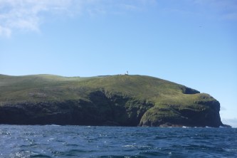
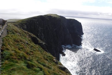
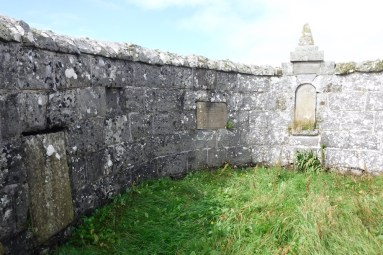
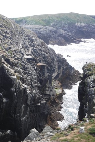
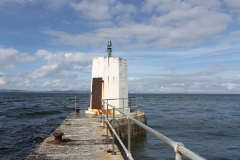
As we approached the island the conditions became much calmer and by the time we pulled in alongside the jetty it was positively calm. Landing on the jetty was easy, much easier than many other landings. A couple of members of the group wandered off over to the tidal section of the island (the South Dog) while the rest of us followed the route of the old tracks leading up to the lighthouse, passing the ruins of the old 12th/13th century chapel. There is a wonderful natural arch in the rock to the right as you walk up. It’s not a big island, but it’s stunning. I wasn’t expecting it to be so beautiful, possibly because it isn’t particularly remote. I always felt that islands that took a long time to get to were often the most beautif

Fidra3
Fidra lighthouse and the old cable drum

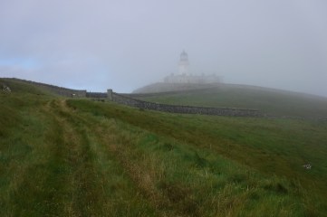
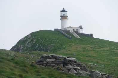
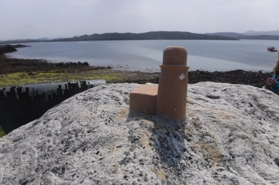
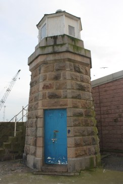
As the highest point of the island is to the east of the lighthouse, once you’ve landed on the island it’s not possible to see the lighthouse. It was only after a few minutes of walking up the old tracks that it came into view. Just after passing through the wall that surrounds the compound, we saw the old cable drum that was used to haul the carts up from the jetty to the lighthouse. We also spotted one of the wheels from a cart on our way back down too.

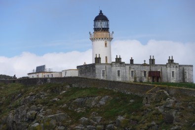
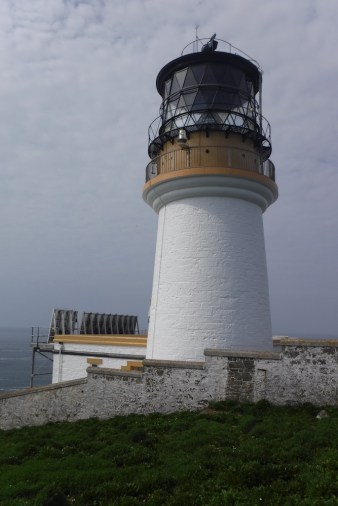
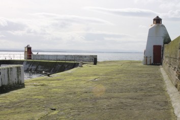
The different land levels around the lighthouse give a variety of perspectives on it. The large rock to the south of island, as one of the other group members said, almost seems as if it was placed there just for people to get a good view/take pictures of the lighthouse from. So often it’s the surroundings of the lighthouse that add to its appeal and that’s definitely the case with Fidra.

Fidra
Fidra lighthouse from higher ground

The lighthouse here was designed and built under the leadership of Thomas and David A Stevenson. The light was established in 1885 and was automated in 1970. In 2009, along with lighthouse on Inchkeith and Elie Ness lighthouse, ownership of the light was transferred to Forth Ports.

After we left the lighthouse, we had a stroll around the old lighthouse garden, which is a fair size. It is covered with old puffin burrows so we had to tread carefully.

Fidra is a stunning island and I thoroughly enjoyed our visit. A little gem in the Firth of Forth! 🙂

Minor lights of Arbroath, the Tay and Fife

Last weekend we received an email to say that a trip to the island of Fidra in the Firth of Forth was imminent, so as we always say we “made it happen” by arranging childcare and time off work. While we’d originally been looking at Monday for the trip, it turned out that Wednesday could potentially be significantly better. After getting the kids to bed on Tuesday evening we set off for Dundee, our destination for the night.

In order to make the most out of the trip we had a look at other east coast lighthouses that were still on the list to be bagged. On Wednesday morning we got up early and set out for a day of lighthouses, with the aim of being in North Berwick for 1.30pm.

Arbroath
Arbroath lighthouse

Our first stop was Arbroath. For most lighthouse baggers this would the start of a wonderful journey out to the fabulous Bell Rock lighthouse or a stroll around the excellent museum in the former Bell Rock signal tower. Due to the excitement of both of these on our previous visit to the area, we had failed to see the lighthouse sitting in the harbour at Arbroath. This one was easy to find, once you knew it was there. A very interesting-looking structure, that you would never guess was a lighthouse from certain angles. There are some nice little staircases and railings around the lighthouse so you can wander around the area freely.

On the way into Arbroath we had another stop-off at the old Vatsetter (Yell) lighthouse at the side of the road. When the lighthouse was originally transferred from Yell it was kept at the Museum of Scottish Lighthouses in Fraserburgh. In 2011 it was moved to Arbroath to mark the bicentenary of the Bell Rock lighthouse, the Year of the Light. It’s always nice to see a lighthouse a bit out of place. Even when you know it’s there, it’s good fun to spot again.

North Carr light vessel

Our next lighthouse was the old King William IV Dock light, which has been relocated to the west of the north end of the Tay Road Bridge. On our way there we spotted the North Carr Lightvessel, which is looking a little worse for wear in Victoria Dock. It has a really interesting history. It was loaned to the Northern Lighthouse Board by Trinity House for use to protect ships from the North Carr reef, just off of Fife Ness, from 1933 to 1976. After that it was used as a floating museum in Anstruther. In 2002 it was sold on and then sold for £1 in 2010. It is a sad condition that it is now in, particularly as it is the only one of Scottish light vessels that remains. There is more details of its history on the Northern Lighthouse Board website.


King William IV Dock
The King William IV Dock lighthouse

We found the old lighthouse next to the Tay Road Bridge. It is also know as the Telford Beacon, in honour of Thomas Telford. This little lighthouse became landlocked after the bridge and supporting road network was built and there is a fascinating time lapse video online showing how the lighthouse was moved (in one piece, might I add) from its former location to where it stands today. It’s great to see that the lighthouse is being looked after and the area surrounding it has recently been improved to support greater movement of pedestrians and cyclists along the bank of the river. If only they had done the same sort of thing with Beamer Rock lighthouse when the new bridge was built over the Firth of Forth! Hopefully that one will make a reappearance again some day.


St Andrews
St Andrews lighthouse


St Andrews was next on the list. Another village we had passed through without realising it had a lighthouse! The small semi-circular lighthouse can be found just above the harbour, in front of the old cathedral ruins. It is clearly not a structure that is raved about in the area, but sometimes that’s a good thing. In researching for my list I had read that there was also the remains of an old lighthouse in the wall of the cathedral. This had been the rear of a range of lights – the front light is long gone. When we got there we found the section of wall it had been on and I quickly decided that the old lighthouse should be demoted due to the tower on which it stood not being built originally to serve as a lighthouse. I was happy to have seen the smaller light above the harbour though, so still worthwhile visiting.

Pittenweem
Pittenweem’s old lighthouse


Carrying on around the Fife coast, we came to Pittenweem. The old lighthouse here sits halfway along the east pier. It was discontinued when the pier was extended. It is very much a fishing village harbour and was fairly quiet while we were there. I strolled out along the pier to see the lighthouse. It’s not the most impressive by any means, and it is currently cordoned off by cones and tape, which I take to mean that there is something structurally unsound or dangerous going on there at the moment. A new beacon exists at the end of the new pier extension, but this doesn’t qualify for the list.


Burntisland inner pier
Burntisland East Pier Inner lighthouse


Before we attempted the lighthouses in Burntisland (which I’d always thought was pronounced “burntis-land” until I was more reliably informed that it’s “burnt-island”), Bob had warned me that this visit may only be a recce for a future visit. It’s a fairly built-up area with the docks very much in use. We took a drive around anyway and noticed a private car park, which looked like it would allow a view to the lighthouses. We drove through the car park and continued on until we reached a fence behind which sat the East Pier Inner lighthouse. It is in quite a bad way now. I had a note that it was a “white tower”, but “rusty tower” would have been a more appropriate description. From the east pier light we could see the West Pier Head lighthouse, which is doing a lot better. Just from looking across to the other pier we could see that there was no way we would be able to get any closer without being approached or getting into trouble, so we were resigned to the fact that we would have to settle for a slight distance bag for this one.

Hawkcraig
Hawkcraig Point lighthouses

Hawkcraig Point in Aberdour was our next stop. It seems like a nice area with some good spaces to walk along the coast. We parked a little further away that we needed to, partly because we didn’t know the area. It turned out we could actually have driven all the way there, but it was good to get some fresh air and stretch our legs. I had two lighthouses at Hawkcraig Point on the list, but I came away with only one. The front of the two leading lights is a more substantial structure. The rear light is taller and thinner than the front and not so easy to spot unless you are heading for the front light and happen to turn around, which is exactly how I found it.


Leith
The former Burntisland Breakwater light, now in Leith


Later on that day, and still on our way to North Berwick, we chose to go through Leith to see the old Burntisland East Breakwater lighthouse, which is now alongside the Water of Leith. By that point we were short on time and, although we used a grid reference and GPS device to find it (which was fairly accurate) it took us longer to find as it was obscured behind trees. I got there eventually though. It’s another example of a redundant lighthouse being displayed for the enjoyment of everyone – the third that day after Vatsetter and King William IV Dock!

After leaving Leith we made it in time for our boat out to Fidra. The lighthouse on Fidra, I feel deserves its own space, so a post on that will follow soon (a link to it will appear here once it is ready). 🙂

A few random bags en route home

I’ve had a couple of short trips away recently, the Isle of Wight and Tiree, and the return journey on these trips has provided a perfect opportunity for some tidying up of lighthouses I still had to visit.

Photo 2018-08-25 09.12.02
The lighthouse at Egypt Point

I had been visiting family on the Isle of Wight last month and, during the process of finalising my lighthouse list, I discovered that the light at Egypt Point (the most northerly point of the Isle of Wight) qualified for inclusion. As is usually the case with places you have lived, you often pass by landmarks without taking much notice. I know that I’ve  been at Egypt Point a number of times, but that was long before my lighthouse definition was decided. So, my dad/chauffeur very kindly took a detour along the seafront and pulled over while he, my mum and aunt all watched me bag the lighthouse (a very kind lady who was walking her dog even paused while I took a picture of the lighthouse)! While the lighthouse is an unusual structure, it is not the most fascinating. Surprisingly, it’s actually quite old and the former lantern and optic is now on display in the Association of Lighthouse Keepers rooms at Hurst Castle. It was only a quick visit, but an important one, just to be confident that it can be ticked off of the list!

The second trip that allowed for more bagging was on the way back from Tiree (see my previous post for details of that very exciting weekend). Although we knew that travelling north on the A9 would be considerably quicker than the more scenic (and slow-moving) A82, Corran Narrows North East lighthouse beckoned. We’d looked it up on the map and wondered if it would be possible to see it from Corran itself, but when we got there it was clear that, with the new and beautiful homes being built along the coast, access would not be possible from there. Not what we were hoping for as the A82 north of Corran is lined with trees, which we didn’t fancy picking our way through.

DSCF5128
Corran Narrows North East lighthouse

We pulled over into a parking area north of Corran and, with both kids asleep, Bob went for a bit of a recce, heading straight down through the trees from where the car was parked. When he returned about 20 minutes later, he was able to report that that route certainly wasn’t the best. He described which point was the best to take from the main road and I set off. It was only after I’d attempted to get down by at least three routes and decided that I must have gone wrong somewhere that I found the lighthouse. It is a “flat-pack” type, but in a wonderful location. It is so close to the A82, but you wouldn’t really know it when standing there looking out over Corran Narrows. Bob had informed me that, to get back from the lighthouse, just head straight up to the road from behind the lighthouse. Amusingly, there was a well-cleared route up this way and, once I’d got back up, I discovered the best point to walk down from (for anyone interested, it’s at the first post to the south of the sharp corner sign)!

DSCF5155.JPG
The non-lighthouse at Dalmore

Further north we finally made a stop off at Dalmore Distillery – sadly not for a tour or taster, but to check out a potential lighthouse we had been meaning to take a look at for a while. On the end of what it known as Yankee Pier (apparently due to it being built by the American Navy during World World I). During my research I’d seen mention of the structure at the end of the pier being a lighthouse – or tower with a light on top, but I was unsure whether the tower was built for the sole purpose of being an aid to navigation or for another purpose. It was a nice walk out to and along the pier, which the kids seemed to enjoy too – probably because they had freedom from the confines of the car for a change! As we reached the end of the pier we asked a couple who were just leaving what they knew of the building, and they told us of the American war link. We both felt that the tower looked a little more military than lighthouse-y! I then spent most of the remainder of the journey home researching its history online and, although there was clearly evidence of a light on top (it is no longer there), there was nothing to suggest it had been built for such a purpose. After much deliberation I made the decision that it doesn’t qualify for the list, based on the aspect of my definition about the structure needing to be built to be an aid to maritime navigation.

Not the most enjoyable bags, but if it helps with ticking some more off… 🙂

Bagging all the way to Barra Head

Last week we dragged the kids and my mother-in-law over to the island of Barra in the Western Isles with one specific target in mind: to get me to the island of Berneray to see Barra Head lighthouse. Bob had visited the island and lighthouse back in July 2014 when I had been 7 months pregnant – we thought not the best time for long and multiple boat trips with potentially risky landings! He had always promised that he’d get me there some time to make up for my missing out then.

The journey to Barra became a bit of a lighthouse tour in itself, beginning with a quick stop at Cromarty. As we were heading south on the A9 we decided to try something different and take the 2-car ferry across the Cromarty Firth from Nigg. It’s a really fun little ferry with just enough space for the two cars. The crossing also gave us a new vantage point for the lighthouse at Cromarty and, after the crossing, we wandered around the building. This was my second time at the lighthouse, my first being during my original tour back in 2012.

On the drive to Oban, we glimpsed Corran lighthouse and, once on the ferry, there was plenty of lighthouse fare on offer. We spotted Dunollie (north of Oban), Lismore, Ardnamurchan, as well as Duart Point, Rubha nan Gall and Ardmore Point (all three of which are on Mull), and a few of the Northern Lighthouse Board’s modern “flat-pack” lighthouses.

DSCF3339
Berneray with Barra Head lighthouse, as seen from the sea

The week started well when our skipper, Francis (owner of the Boy James who routinely runs trips to Berneray’s neighbouring island of Mingulay) announced on the Monday morning that we would be heading down to Berneray first that day. A great start to the week, and exactly what I wanted to hear! We travelled down the east side of the islands of Sandray, Pabbay and Mingulay on our way there. The majority of the time we were sheltered from the westerly wind by the islands, with occasional relatively rougher (or should that be “wetter”?!) sections in the more exposed areas.

The landing on Berneray was very easy, although we were surprised not to have landed on the island’s pier. Instead we arrived on the rocks on the north east of the island, just to the east of the pier. Thanks to both the Boy James and its tender being well set-up for moving onto and off of, getting onto the island was easy enough.

DSCF3229
Barra Head lighthouse surrounded by cloud

There is a clear track up from the pier to the lighthouse and we joined this track near an old shed close to the pier. It’s a fair wander up to the lighthouse, but there are points of interest scattered along the way with old houses in various states of disrepair, the helipad presumably used by the Northern Lighthouse Board, and what appeared to be a well with a pump. As we walked up the hill to the lighthouse the cloud was coming and going, at one point entirely obscuring the lighthouse. The light in Barra Head lighthouse sits higher above sea level than any other in the UK. While the lighthouse is only 58 feet (just over 17.5 metres), the huge cliffs on which it is located mean the light operates from a height of 693 feet (slightly over 211 metres). It is incredible to see. As you walk the track, the lighthouse gets bigger and bigger, but once you reach the start of the lighthouse wall and look over the edge you see the true extent of the cliffs, which dwarf the lighthouse.

DSCF3244
The lighthouse with the old keepers’ cottages in the foreground

The buildings, which I assume were the keepers’ cottages, in front of the lighthouse on the landward side are looking worse for wear, not surprising really given that the station was automated in October 1980 and the wild weather that hits the island on a regular basis. We were surprised to hear that the skipper of the Boy James had lost 19 working days in the month of July this year. This says a lot about the sea conditions and weather in the area; the sun may be shining and conditions can seem calm, but the extreme exposure changes everything.

DSCF3275
The view east from the lighthouse compound

Often we have visited islands with lighthouses on calm days and you can’t imagine how wild it can get. Barra Head is different though. The dramatic scenery of the cliffs and the slippery courtyard outside the lighthouse hint at just how bad it can be. Some of the aerial images I have seen since on the Canmore website of the cliffs on which the lighthouse perches give me the chills. You then get a better grasp on just how close we were to the edge of two cliffs at exactly the same time when we walked to the highest point on the island, which is just next to the lighthouse. The lighthouse sits right at the top of an extremely tall gully in the cliffs, and I imagine this gully sends up some pretty huge waves at times. I mentioned the word “dramatic” before and I think that is the best word to describe it in any conditions.

DSCF3320
The three graves inside the keepers’ graveyard

The lighthouse itself was built by Robert Stevenson and completed in 1833. While the island may seem like an almost impossible place to live compared to today’s standards, it was home to a small number of people in the past. The last remaining residents though were the lighthouse keepers who lived in the cottages there until the station was automated. The keepers, interestingly, have their own walled graveyard on the island not too far from the lighthouse. Within the walls are three graves, including those belonging to two of the keepers’ children who died at particularly young ages. The keepers’ cottages, which I referred to above, appear to have an interesting history since the keepers left. There is a fascinating summary of the plans for the buildings at buildingsatrisk.org.uk since automation. I really hope someone manages to find a use for it before too much more damage is done.

Berneray is a very special place and I feel privileged to have been able to make it there. If I were given another chance to visit then I wouldn’t hesitate to take it. If you are ever thinking of heading that way then I would definitely recommend getting there on the Boy James. A fantastic trip and a great day, and the kids were in bed when we arrived back at our accommodation too! 🙂

The Flannans – finally!

For the past three years we have been holidaying in the Outer Hebrides, based on Lewis or Harris, with a chartered boat lined up and ready to take us, and a number of other hill/island baggers out to the Flannan Isles. All three times the trip has been cancelled due to poor sea conditions.

lighthouse1
Eilean Mòr lighthouse

The Flannan Isles lie 32km west of Lewis and, as you can imagine, are subject to some pretty wild seas at times. Having spent so many years waiting to get out there, a part of me thought it might never happen. But then we saw the forecast for last week, which coincided with what had become our annual holiday to the Western Isles. Sunshine, virtually no wind. It was looking promising and even more so when we received a message to say that our boatman, Seumas Morrison of Sea Harris, was confident that we would make it out there. Landing, though, would be another matter entirely…

Of course, my priority was landing on Eilean Mòr, the main island, which boasts the famous lighthouse (more on that shortly). The group we were with, including Bob, were also interested in landing on the other seven islands (or lumps of rock, in some cases) that make up the Flannans. The sea looked nice and calm on the morning we headed out. None of us expected to be able to land on anything other than the main island, and we weren’t even sure about that one!

east landing
The east landing on Eilean Mòr

After an hour and 40 minutes on the boat we approached Eilean Mòr. Quite quickly we realised that a landing would definitely be possible, although we’d need to time it right to avoid getting wet feet. Very kindly, Bob had taken along a rope and he joined a couple of others as the first group to land, which then gave him time to set up a rope/handrail to help the rest of us. We arrived at the east landing, which very helpfully still has many of the steps intact. A clear path then took us up and in a big, sweeping route around to the lighthouse. The path followed what would have been the tracks (removed now), which would have taken the supplies up to the lighthouse. Apparently the interchange point between the tracks going down to the east landing and the west landing – which they would change manually – was known affectionately by the keepers as “Clapham Junction”.

lighthouse2.JPG
Eilean Mòr lighthouse

The lighthouse sits beautifully at the top and there’s a real awe-inspiring feel about the place, possibly helped by its remoteness and how challenging it is to get to. Slightly off the path to the right as you walk up is the old chapel (known locally as the “dog kennel” apparently, which says a lot about its size!) As you walk up, the helipad is just behind the chapel.

On such a calm day, it was difficult to imagine how wild it could be out there, although the state of the west landing area suggests the severity with much of what was put in place for the keepers’ landings, including the steps, having been washed away.

It is easy, before visiting the island, to view it solely as “the one from which the keepers went missing”, but visiting the island gives you the opportunity to see it for what it actually is, which is a beautiful structure, built in (what must have been) a challenging location that now makes for a very special place. There is a feeling you get on these islands off of the west coast of Scotland that I haven’t experienced anywhere else – possibly, in part, due to the low number of visitors to these islands. Hyskeir is another example as is the Eigg lighthouse on a small island to the south east of Eigg. It’s isolation, but the beautiful kind that soothes the soul. It probably helps that I’ve been to them on calm, sunny days!

west landing.JPG
View of the west landing on Eilean Mòr

Descending down the path and back on to the boat went smoothly with our “handrail” in place! We then went on to get those more adventurous members of the group landed on all of the other islands, which I sat back, viewed the Eilean Mòr lighthouse from various angles and watched one of the boatman successfully catch numerous coalfish and some fair-sized pollock. It was all very relaxing.

Later in the week, we grabbed the opportunity to visit the exhibition and memorial dedicated to the three keepers lost from Eilean Mòr in 1900. For those not aware, on the 15th December a vessel passing by noted the light did not appear to be operating. When a boat was sent on 26th of that month (after being delayed by the weather from 20th) for the changing of the keepers, the first man onto the island reported that none of the three keepers were to be found. There are numerous stories about what could have occurred, including a poem that took a little artistic licence with the story. The most likely story, in my opinion, is that one or two of them got into some trouble at the edge of the island and the other went to help resulting in all three being lost to the sea. It’s a very sad story and the exhibition and memorial pay tribute to them.

exhib
The lighthouse exhibition in Breasclete

The exhibition, titled ‘Waiting for darkness to fall’, opened in April at Breasclete Community Hall and is open daily from 2-4pm. The community of Breasclete chose to develop the exhibition and memorial as it is in the village that the lighthouse’s shore station was based (it is still there now and stands out clearly from the rest of the buildings. A picture can be found in one of my previous posts). It features descriptions of the Flannan Isles, the building of the lighthouse, what is known about the disaster and the aftermath. A great deal of information has been pulled together for the exhibition, including excerpts about the island from various publications, weather reports from the time the keepers went missing, newspaper cuttings following the loss of the keepers, and pictures of the development, building and launch of the memorial, which is located just half a mile down the road, next to the water’s edge.

We spoke to a very friendly gentleman from Breasclete Community Association who was on hand to chat to visitors and he informed us that there are a number of potential plans in the pipeline to ensure the exhibition can remain permanent and expand upon it. He said that they hope to introduce visits out to see the island itself by boat or helicopter at some point and also look for a more permanent home for the exhibition. I had read online that there has been some talk about the community purchasing the shore station and using the building as a home to information about the lighthouse and the missing keepers.

memorial
The Flannan Memorial in Breasclete

Of course, we also had to visit the memorial. It really is a lovely piece of work. The artist James Crawford of Garynahine has carved the shape of the lighthouse out of sandstone and it sits on top of a Lewisian Gneiss rock shaped like Eilean Mòr. This stone is on a bed of smaller stones with beautiful sandstone block-work around the edge. A bronze wave appears to the left of the island, the wave heading straight for it. A plaque features on the front with the names of the three keepers: James Ducat, Thomas Marshall and Donald Macarthur. I’ve included a couple of  extra pictures below of the finer details.

Having the opportunity to see both the island and lighthouse as well as the exhibition and memorial in the same week was a real treat. I feel very lucky to have been able to do so. 🙂

memorial2.JPG

memorial3.JPG

North and South England: the old and the new

On a recent trip to the Isle of Wight to see my family we made the most of the fact that we were driving almost the full length of the UK by stopping off to bag one new lighthouse for me and re-visit another. Comparing these two gives some idea of the variety of places and structures that I have often encountered when visiting lighthouses. That’s part of the joy of it, that some lighthouses are fairly reserved and serve their purpose with minimal fuss, while others are shouted about and bellow “look at me”!

IMG_7939
Beaulieu River Millennium Beacon

I’d been aware for a while that there was a lighthouse near Lepe Beach at Beaulieu, not far from Southampton, and we had a bit of time to spare before our ferry so decided to head over that way. The lighthouse here is one of the newest in the UK, having only been erected in 2000 (it’s official name is the Beaulieu River Millennium Beacon). A local committee was formed to address the concerns over navigating from the Solent into the river and they finally made the decision to build the lighthouse to resolve this, as well as marking the start of the new millennium. There is a detailed history of the lighthouse and why/how it was installed in an article originally published in the Leading Lights journal. The article can be viewed online here. It may not be the most majestic and inspiring of buildings, but it is much closer in appearance to a traditional lighthouse than many of those that have been installed in more recent years (particularly the “flat pack” lighthouses that can be seen in parts of Scotland now). The land that the lighthouse sits on is within the grounds of Lepe House, which is privately owned, meaning that access to the tower is restricted. So I had to settle for a view from the roadside and small pebble beach just in front of it. It’s close enough though.

IMG_8343
Souter lighthouse

Our second lighthouse was not only in an entirely different part of England, but also completely different in appearance. I had first visited Souter lighthouse, to the south of South Shields, on my original tour in 2012 and then again while in the area a few years ago. Both times I’d managed to miss it while it was open though. This time, while heading back north, we made sure to pay a visit when we could get inside. It is a distinctive lighthouse from the outside and very well maintained. The fog horn, alongside the lighthouse, makes for a particularly dramatic picture.

Souter lighthouse was the first in the world to be purpose built to run on electricity. You can access the light room in Souter lighthouse at your own leisure, which was great for us as it meant our three-year-old could climb to the top, counting the steps, at his own speed. This was the first time he’d climbed up the final ladder to reach the light room and also the first time our daughter had been into the light room of a lighthouse.

IMG_8349
Souter foghorn

It’s a great building to wander around. After the lighthouse was decommissioned in 1988, it was bought the The National Trust. They have clearly done a lot of work on it, including maintaining the rooms (and keepers cottage) as they would have been when it was a manned lighthouse.

The Leas is also a wonderful area for strolling around. As well as the stunning scenery, there are interpretive panels along the coastline describing how the area has changed over the years, with Whitburn Colliery and the associated creation and demise of the Marsden community. It really is an interesting place, which satisfies a number of interests. So, if you enjoy lighthouses, geology, history, nature, coastal walks, or just a fun day out for the family then it’s a perfect choice if you’re in the area 🙂

2017 bagging season begins!

Those who have seen some of my earlier posts (or even looked at the list of months that I have added posts on here) will know that , for me, there is such a thing as “lighthouse-bagging season”. Of course it’s possible to enjoy them just as much in winter, but the dark mornings and evenings aren’t conducive to a good bagging day.

Whenever the clocks change I’m glad of the lighter evenings and how much more of a day you get to enjoy the outdoors. So it’s no surprise that a few weekends ago we set off to visit a total of 10 new lighthouses and a revisit to a few others too. Due to a review of lighthouses we conducted over the winter, we were able to find some more to keep us going (more on this and the definition of ‘lighthouse’ in a future post).

Nairn.JPG
Nairn lighthouse

So, that weekend the stretch we covered was on the north east coast between Nairn and Gourdon, just to the south of Inverbervie. Our first stop was Nairn East Pier where I got my feet wet. The design of the pier (which is narrower at the end) means that every now and then a larger wave washes over the top, which is exactly what happened as I approached. It would have happened on the way back too had I not been more prepared for it by then. The lighthouse itself has your typical lighthouse base, but is now topped with a “light on a stick” as I refer to them. I’ve not been able to find out any of the history of the lighthouse itself. The pier that it sits on offers some great views across one of the town’s sandy beaches to the east and towards the Black Isle to the north west.

Burghead.JPG
The two lighthouse at Burghead

Our next stop was the small town of Burghead where the sturdy-based lighthouse sits on the North Pier. The small lamp looks tiny in comparison to the big, white base. I was nicely surprised to see a squat little structure that also meets my requirements right at the end of the pier. It’s essentially just a cupboard with a light in it. It’s a great short stroll along the pier and a sample of the fantastic rock that adorns this coastline can be seen at the entrance.

Lossiemouth.JPG
Lossiemouth south pier lighthouse

There isn’t a huge amount to be said about the lighthouse on Lossiemouth south pier, except that it gets less and less interesting the further up it you look. It sits on a concrete base with a metal base to the main structure. Out of this metal comes an arrangement not dissimilar to an electricity pylon with a balcony on top. On top of that are a few contraptions on a post including the light. There are some lighthouses that just don’t inspire you (even I will admit that) and this is certainly one of them!

Findochty.JPG
Findochty lighthouse

The little gold lighthouse on the end of the breakwater at Findochty had a bit more character to it – partly because of it’s colour. There’s not a lot to it, just a lamp room with a door that sits at the top of a spiral staircase. Having done some research into this, now disused, structure I discovered that it is usually painted gold for the summer months and white for the winter. The minutes of the local Community Council meetings towards the end of last year suggest that the intention   was that it would be painted white, as per this schedule, at some point, but clearly that hadn’t happened, so I suspect it will remain gold for now. I quite like it that colour – it makes it more memorable. We also spotted a dolphin out to sea just before we left, which is always nice.

Portsoy.JPG
Portsoy lighthouse

Portsoy is a very pretty little village which sits between the neighbouring villages of Cullen and Whitehills (both of which I visited on day 13 of my original lighthouse tour). While it shares some similarities with the two, Portsoy seems to have its own little charm. The small, white lamp room of the lighthouse sits on top of a private building. It’s possible to get views of the structure from a range of angles though thanks to the cosy little harbour. A beautiful, artistic metal dolphin sits across the other side of the harbour, which adds to the picturesque scene.

Peterhead north.JPG
Peterhead harbour north lighthouse


I wasn’t necessarily looking forward to our final stop for the day, Peterhead. My main memory of it last time was my stay at the campsite and the creepy old men who were also staying there when they only lived a few miles along the road. This time though we were searching the more built-up harbour area for a couple of, what I thought would be, less obvious lighthouses. We were just about to enter the pier that reaches out to the north of the harbour, heading towards the lighthouse near its end when we spotted a lighthouse just at the side of the road. Unlike many of the others we’d seen that day, this looked like a “proper” lighthouse with the stone base and lamp room integrated. After stopping for pictures we continued along the pier and through the various fishing-related buildings to where we were expecting a lighthouse to be. There was, it turned out, nothing to be seen there (apart from a view across to the second lighthouse) and further research has explained the relocation of the north harbour lighthouse. In April 2015 an application was submitted to Aberdeenshire Council to make alterations to the harbour at Peterhead, including the dismantling and re-erection of the lighthouse to its new location. The application states that: “It was proposed the lighthouse would have the masonry moved on a block by block basis after each block had been marked and recorded for position and then erected in the new location.” The application then goes on to say that the lighthouse had already been removed by the point the application was submitted without authorisation. It is noted in the document that the new/proposed location of the lighthouse would make it more accessible for the public, which it certainly is. I would have been quite happy to not have had to go searching around the numerous fishy buildings there and seen fish guts being dumped!

Peterhead south.JPG
Peterhead harbour south lighthouse

The second lighthouse in Peterhead harbour was much easier to find, being located just in front of the Peterhead Port Authority building. It’s basically the twin of the relocated structure, but isn’t looking quite as rejuvenated as it’s partner (presumably they gave the north harbour lighthouse a bit of a clean when the moved it!)

Our weekend of bagging new lighthouse continued, but more on that in the next post. 🙂