5 days in Orkney – day 1

It feels like a long time since I wrote a post on here although it’s really not been so long at all. It’s been a busy year though, but I’m delighted that it’s nowhere near over yet for my lighthouse adventures.

Gathering a small group of island and lighthouse baggers, we set off for Orkney last night and were delighted to see that the forecast for our entire five days on Orkney was looking calm and dry. The mist that had plagued the area for a few days earlier in the week had also lifted. With a report from the Paul at Northerly Marine Services that it was due to be flat calm, it was all looking very positive for my endeavour to “tidy up” all of the Orkney lighthouses I’d yet to do that weren’t covered by scheduled ferries. On the way to Stromness from Scrabster last night we, of course, spotted the two lights on Graemsay as well as Sule Skerry shore station, which was fantastic. I grow fonder of Orkney every time I visit.

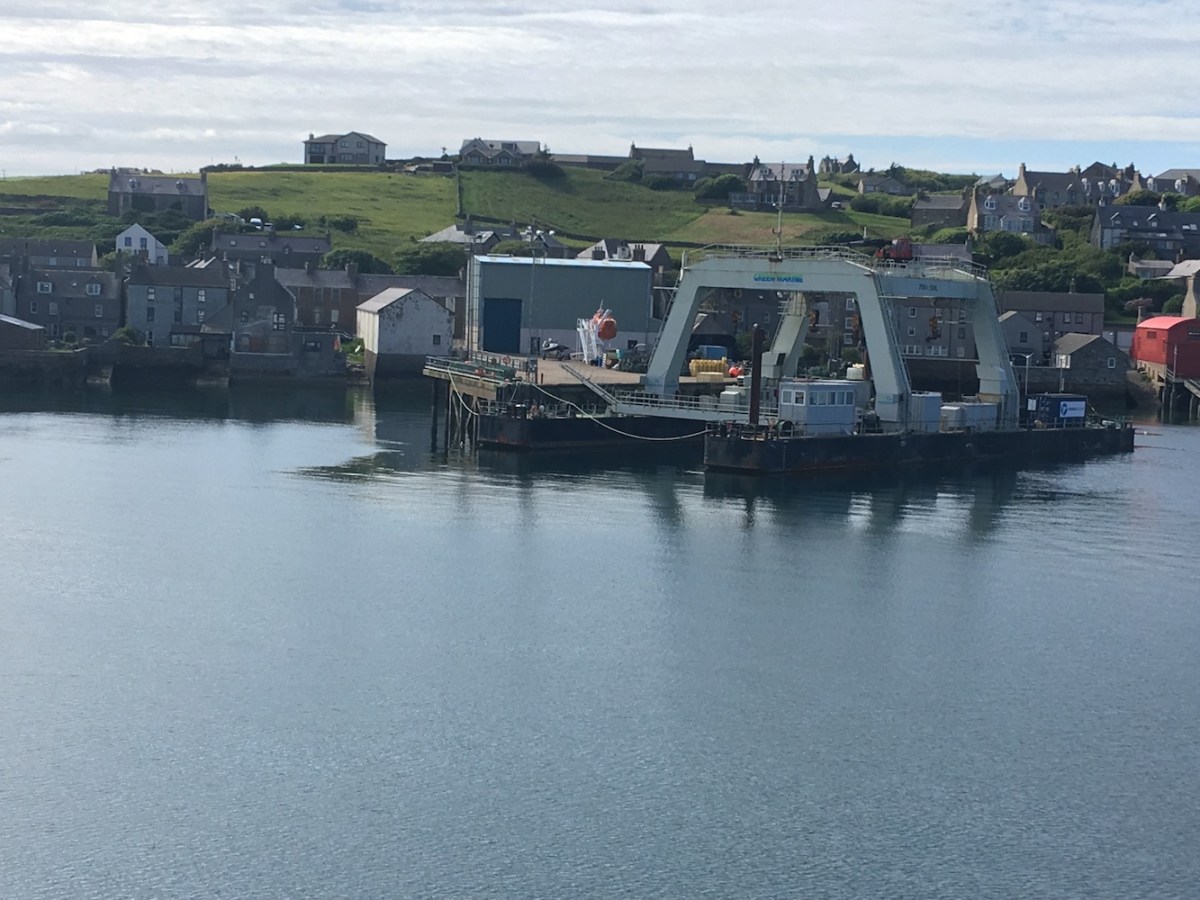
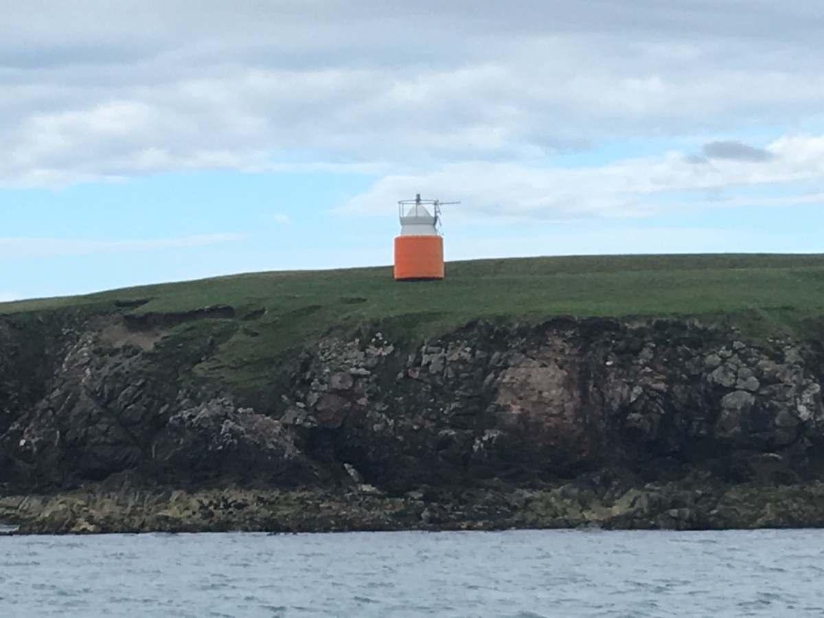
This morning we watched Paul’s boat, Sula, glide into Kirkwall Harbour this morning, and a short time later we were off, waving goodbye to the little old Thomas Telford light in the harbour. Our first two stops were the islands of Muckle Green Holm and Linga Holm, neither of which were home to lighthouses, but the island bagger were pleased to land on those two.

Kirkwall
The lifeboat at Kirkwall along with the old lighthouse

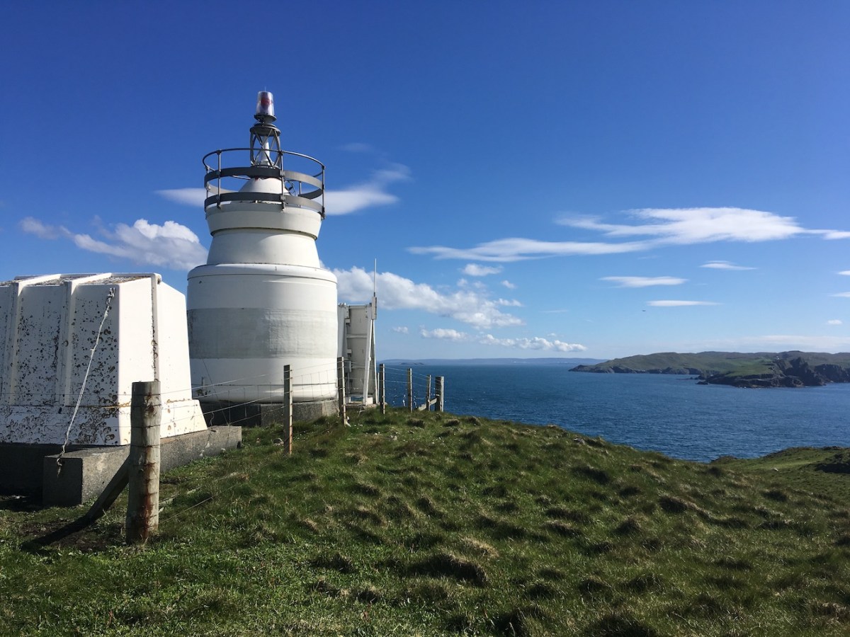
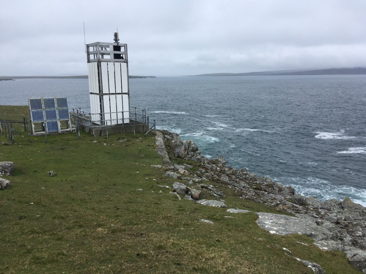
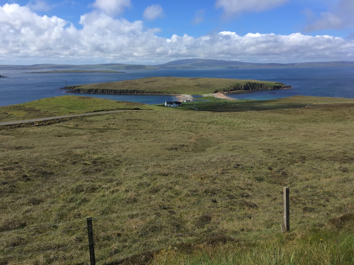
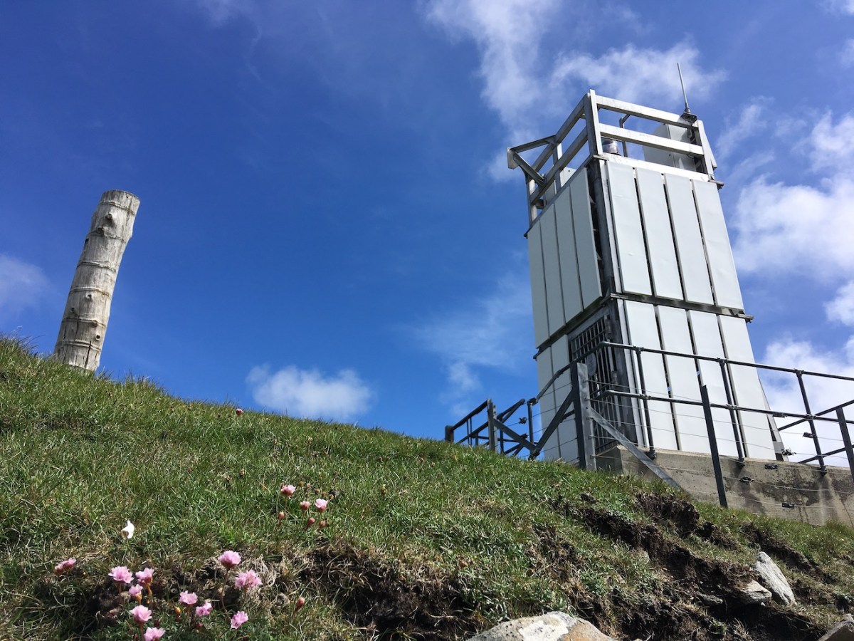
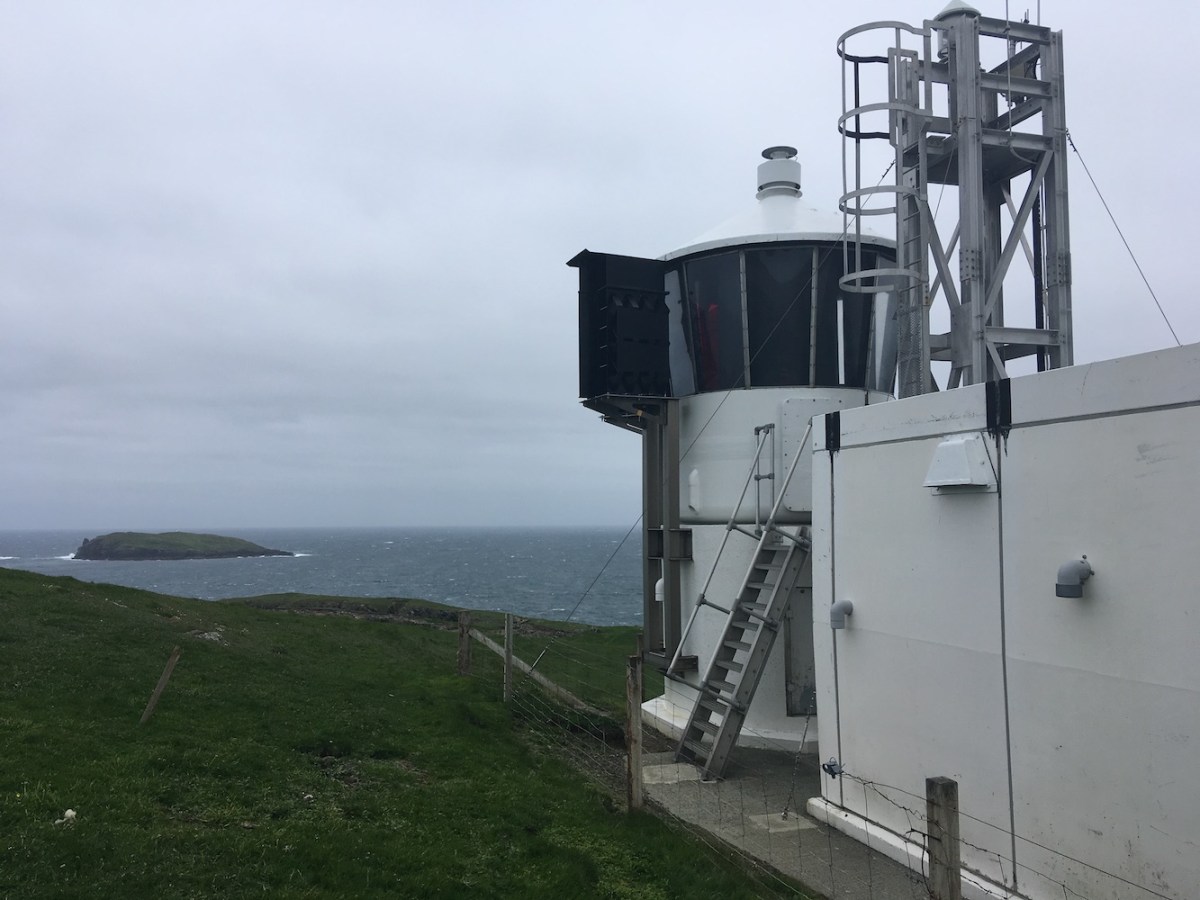
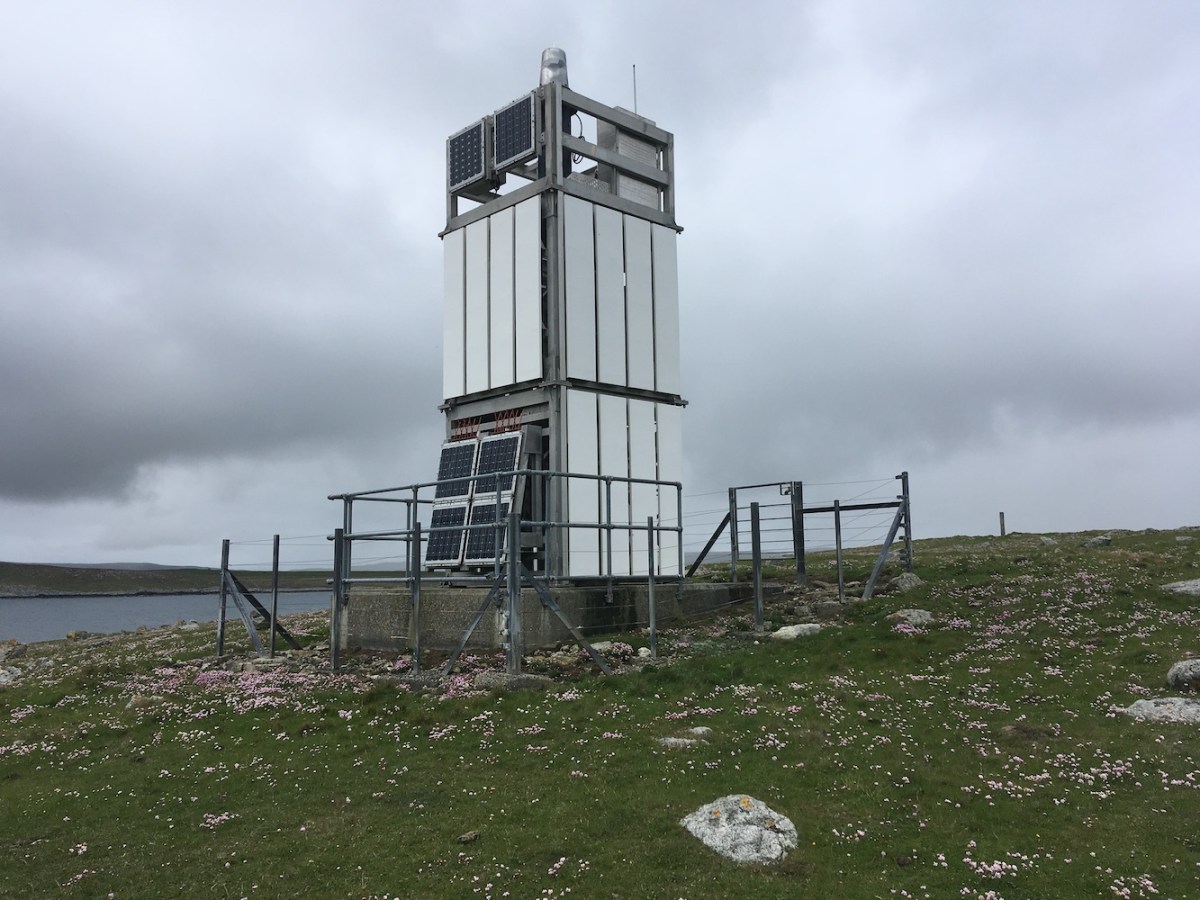
In preparation for the trip, I’d been in contact with the monks at Golgotha Monastery on Papa Stronsay. They were happy for us to go, so that was our next stop. As soon as you arrive at the pier you are greeted by welcoming signs and as you walk through the grounds there are some lovely little touches that have been introduced since the monastery was established after purchasing the island from a cattle farmer. We met one of the resident monks who was very kind and welcoming and wished us an enjoyable time on the island. That sort of thing really enhances your enjoyment of these places. It was a bit of a walk to the lighthouse, but all relatively flat so quite nice really. The island baggers headed off to the high point while I continued on with my flat-pack partner in crime. This one was fairly standard, as many of them are, but again in a great location. The island baggers joined us a short time later and it was great to see them wanting to visit another flat-pack lighthouse. Bob has always been interested in visiting them anyway (even if it is mainly just to get me there), but the others in the group seemed pleased too. It’s a fantastic island with a lovely feel about it.

Papa Stronsay
Papa Stronsay lighthouse

After leaving Papa Stronsay we made a stop on Stronsay itself while the island baggers got a pre-arranged taxi (organised by the really helpful skipper) to take them closer to the high point of the island.

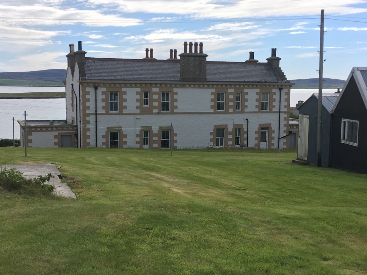
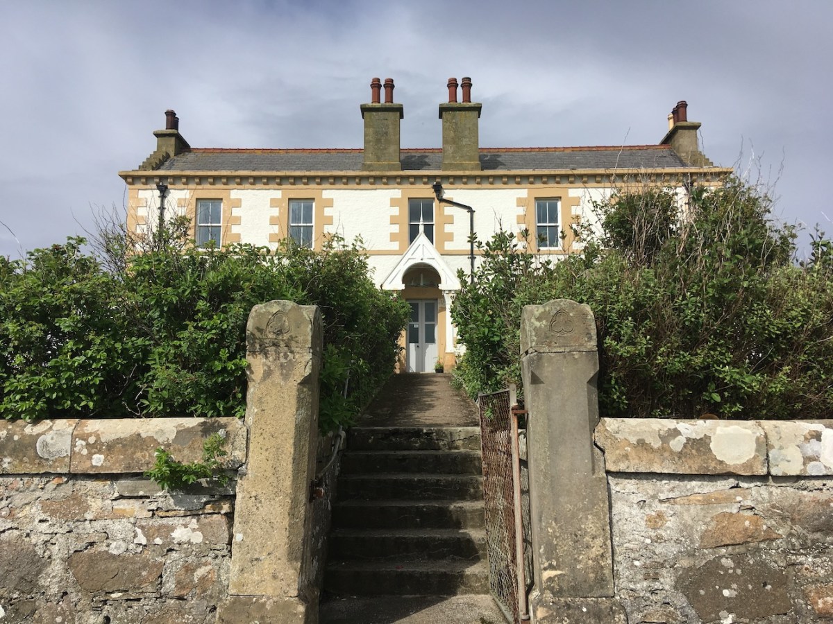
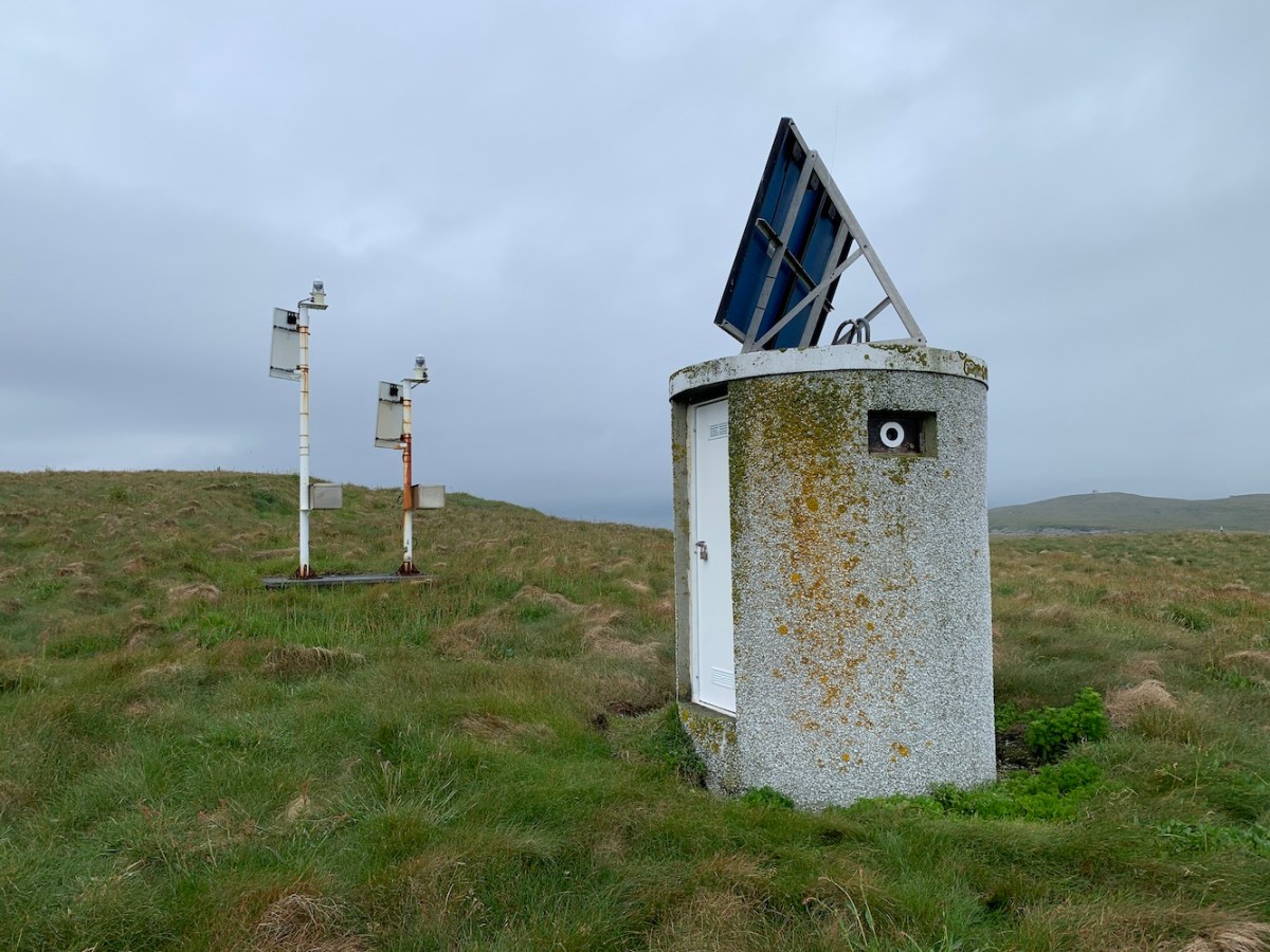
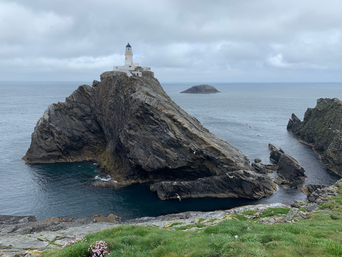
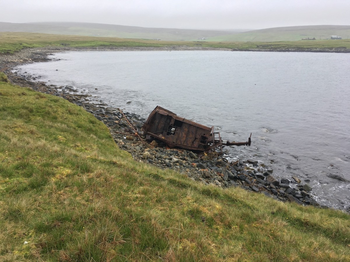
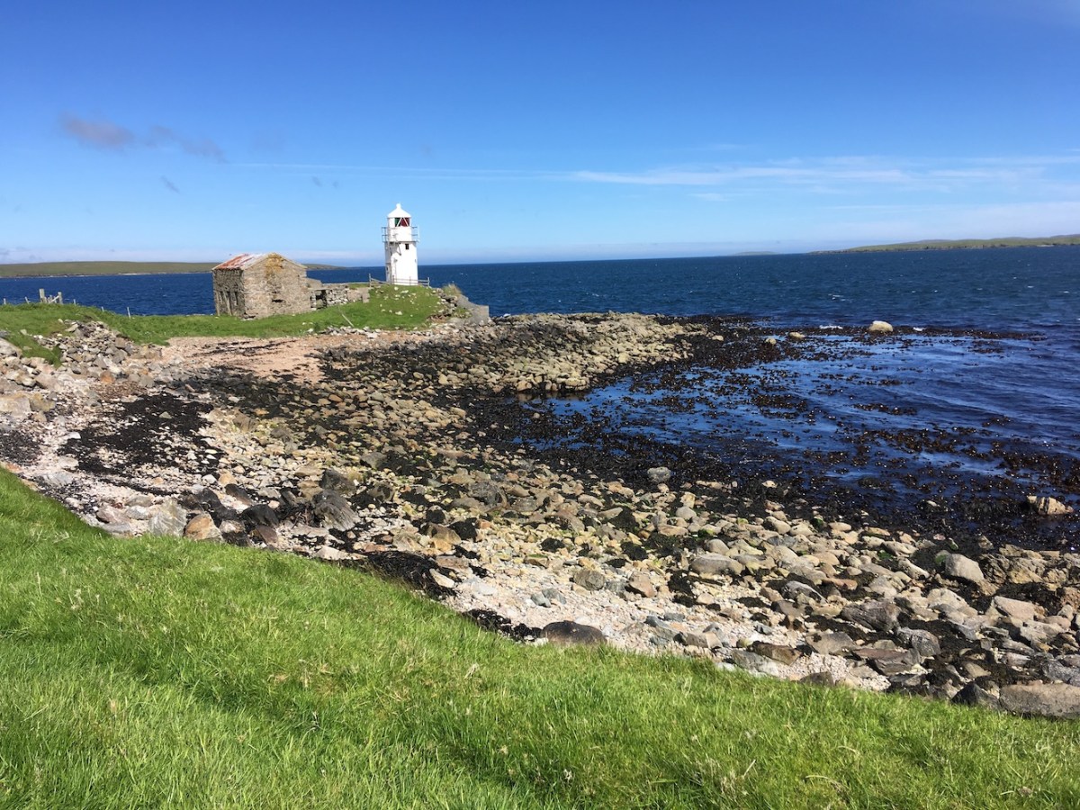
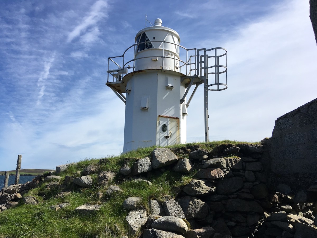
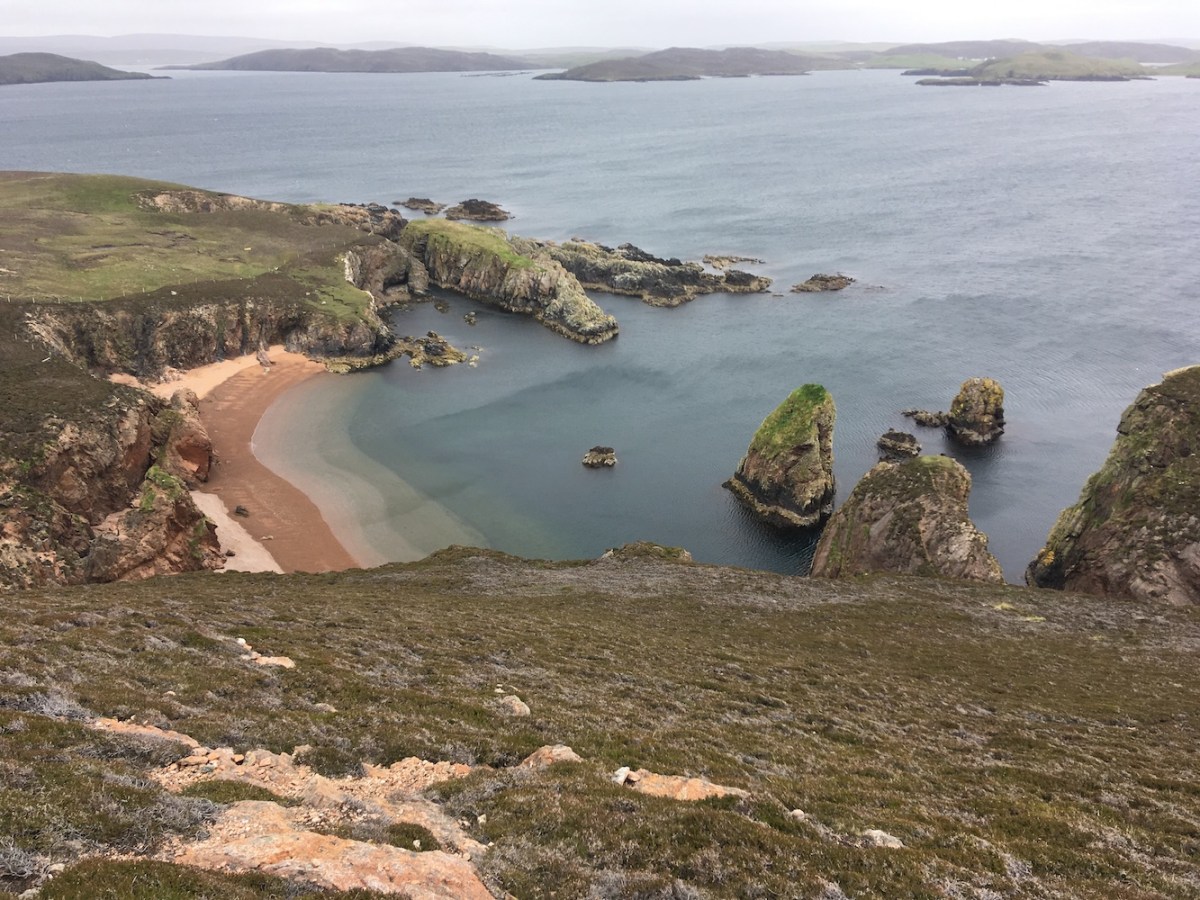
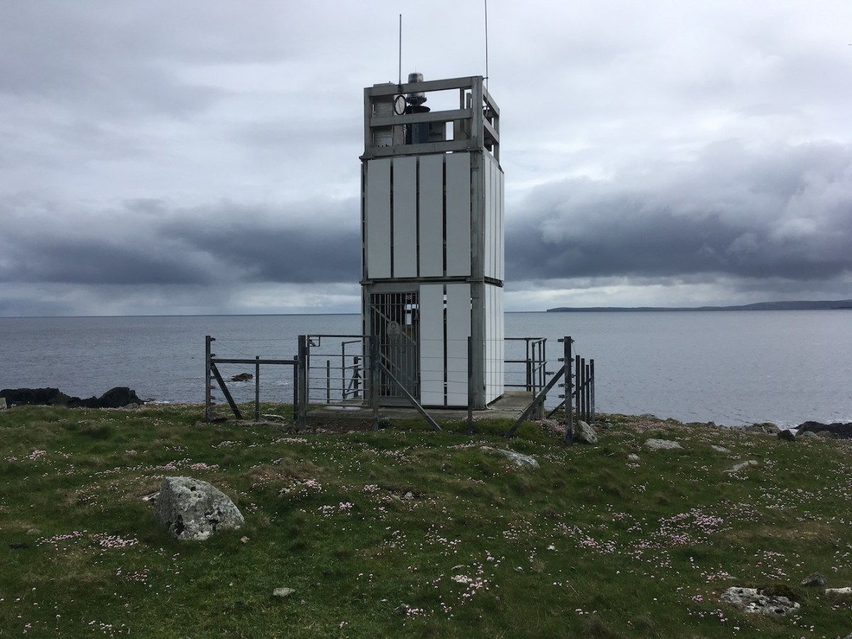
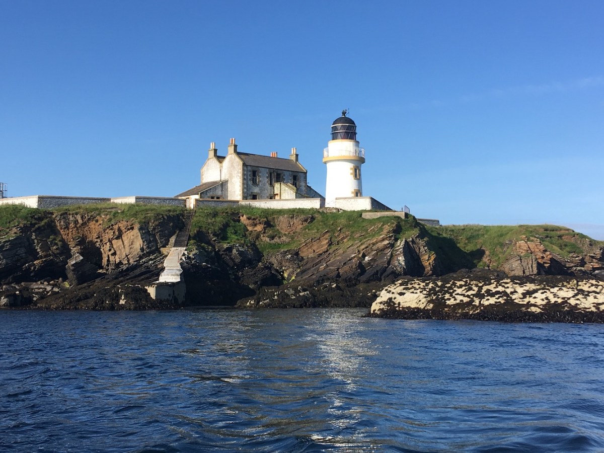
Heading south our next stop was Auskerry. I’d seen the lighthouse on Auskerry from the ferry to Kirkwall from Lerwick in late June and realised how beautiful it was then, so having the opportunity to visit it was great. I’d contacted the owner of the island a few weeks ago to check that she was happy for us to visit and fortunately she was. Landing on the island, as was the case with all of the lighthouse islands today, was really straightforward, just step off of the boat onto the slipway. From the landing it is a really short walk to the lighthouse, and what a lighthouse it is! There’s something very elegant about it. It looks different with its band of bamboo/buff etc. underneath the very top section of the lantern. It’s a tall tower and you can see why when you realise how flat the island is. There were some sheep roaming in the fields around the lighthouse (and we spotted the old sun dial in the neighbouring field), but we all tried not to bother each other too much. The best view of the lighthouse is from the beach side, particularly with the position of the sun as it was at the time. There are the remains of a wrecked ship at the coast here too. As we arrived back at the slipway we spotted the owner of the island who lives there. It was nice to meet her. What a life she must have, living there with her family. The certainly are keeping the buildings attached to the lighthouse in good condition, which is always lovely to see.

Auskerry.JPG
Auskerry lighthouse

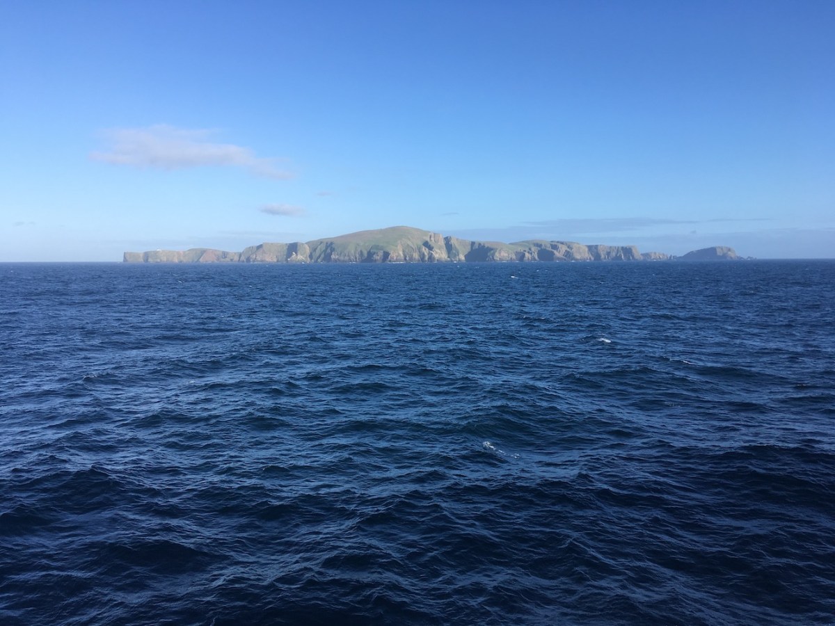
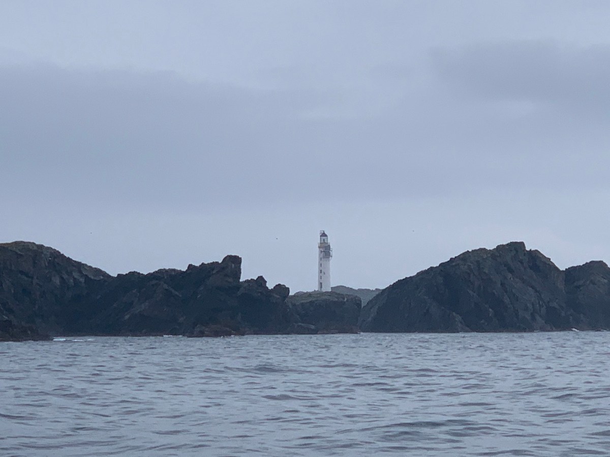
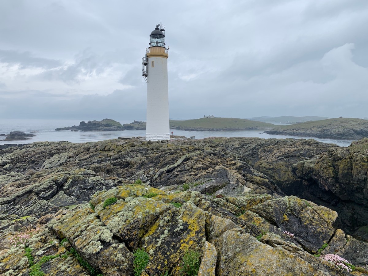
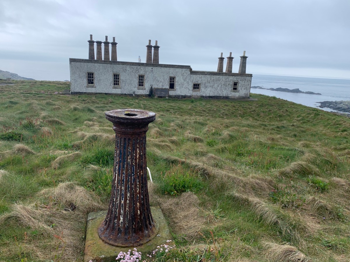
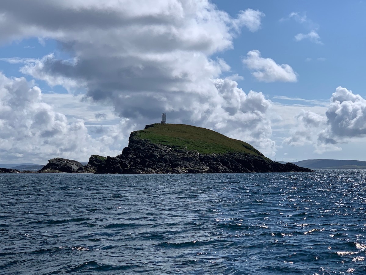
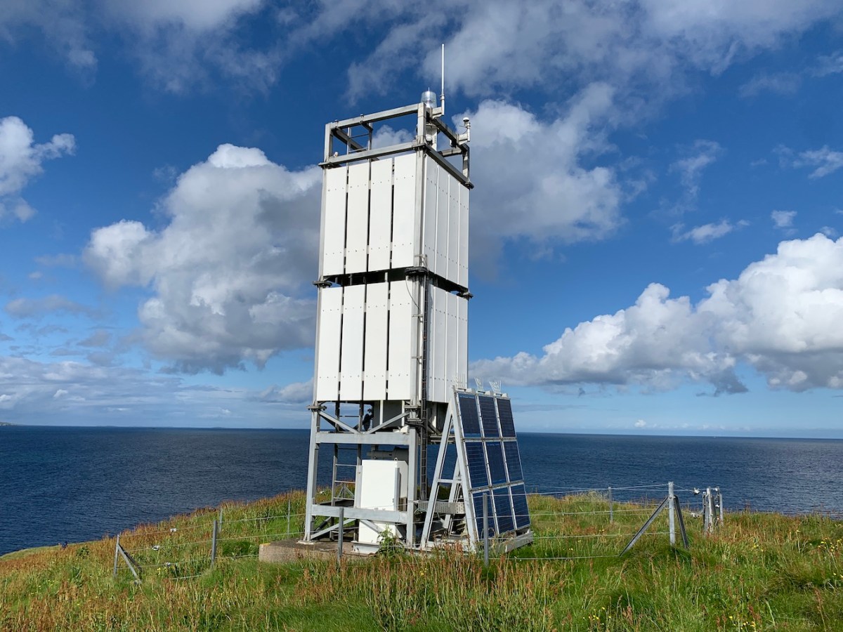
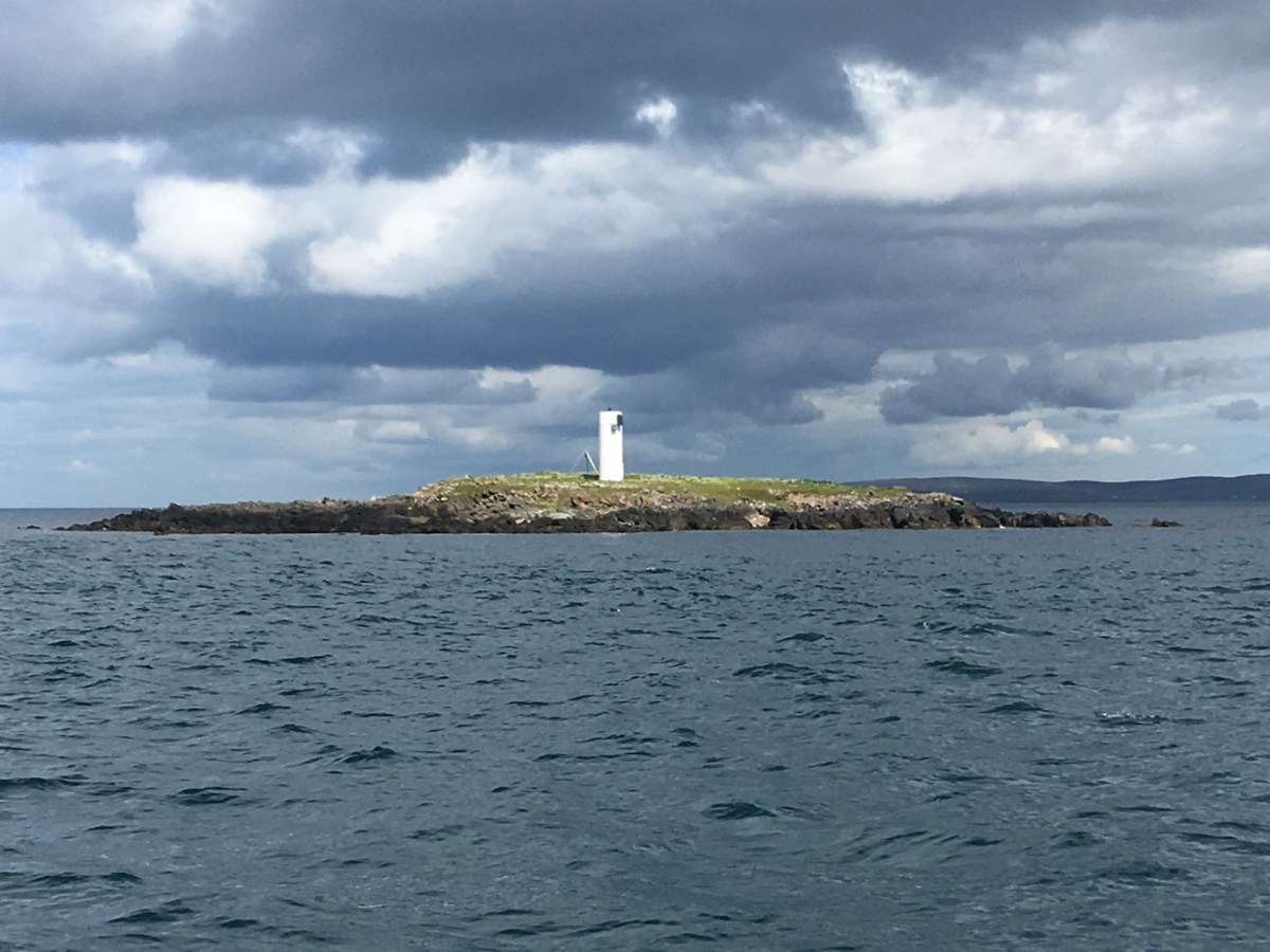
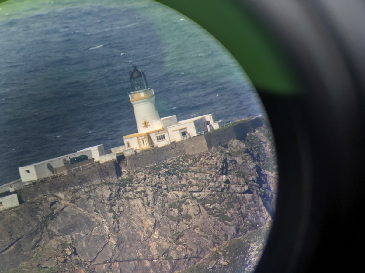
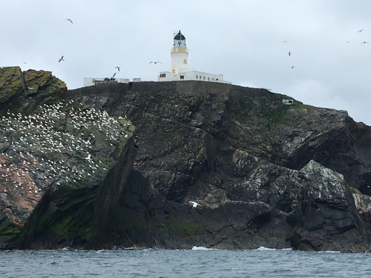
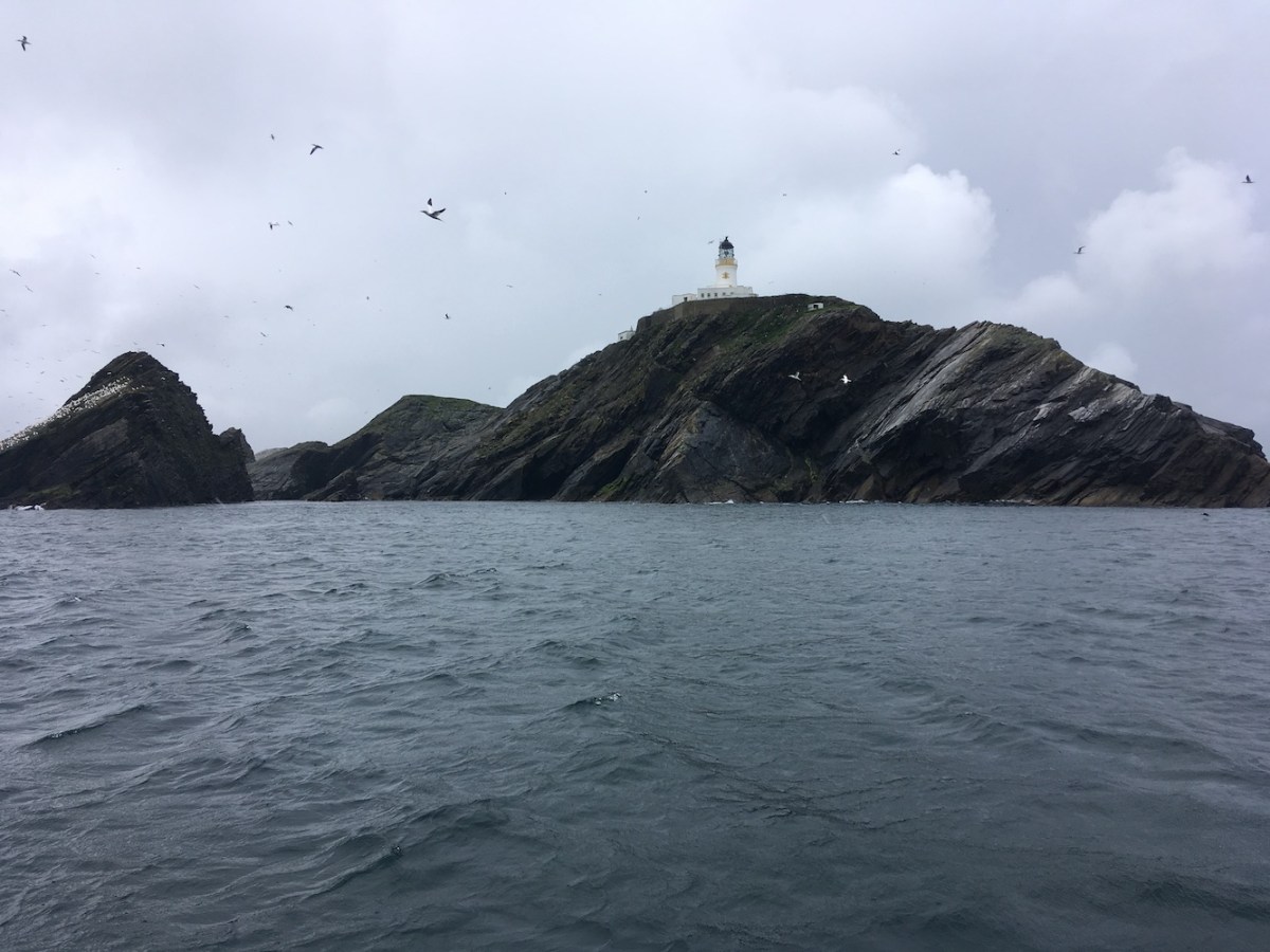
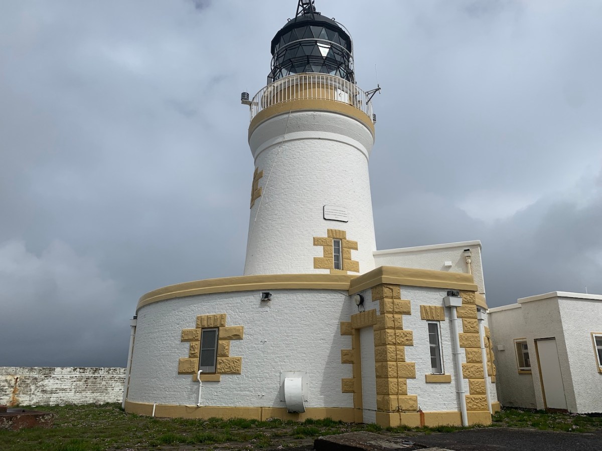
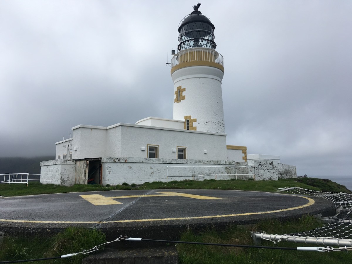
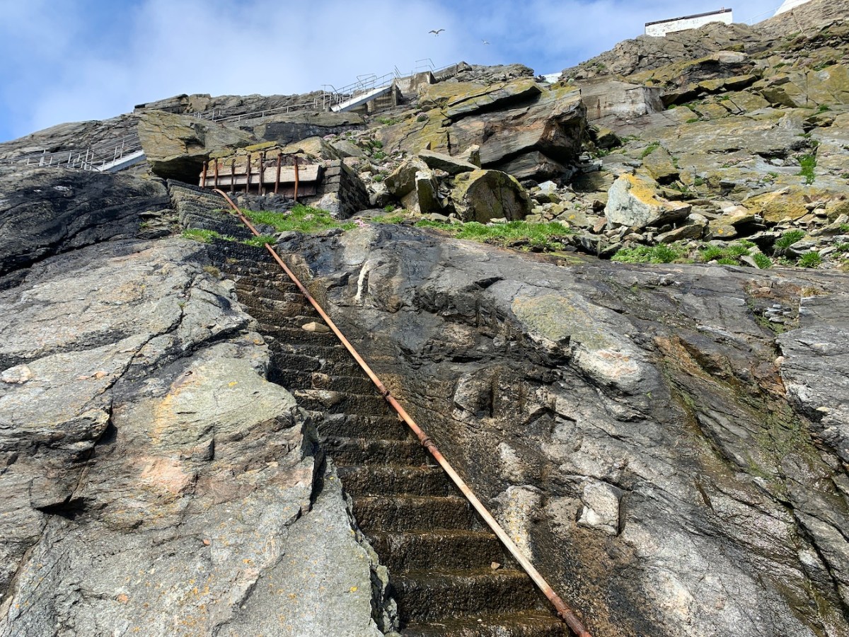
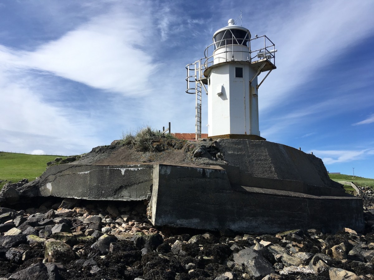
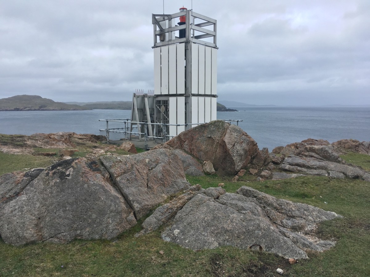
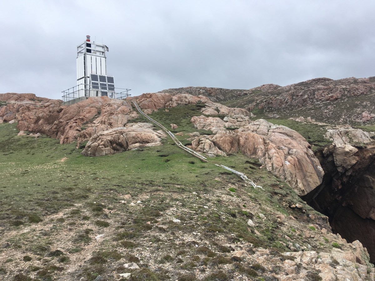
It was time to leave Auskerry, but onwards we went as the next island that beckoned was Copinsay. As opposed to the flatness of Auskerry, Copinsay rises up gradually from sea level on one side to rather high cliffs on the other. In that way it was very reminiscent of Barra Head lighthouse. It’s a bit of a stroll up to the lighthouse, but entirely worth it. We stopped off at the helipad on the way and checked out the panoramic views from there – it really was lovely weather by this point. The lighthouse came closer and closer until we were there and I headed up to the highest point of the island to get a wonderful view of the tower standing there alone with some fantastic clouds above it. It’s not a big tower, it doesn’t need to be, but what it lacks in height it makes up for in general appeal. Once I’d left the high point and made my way down to the gate, during which time I squealed about a bonxie flying nearby and dashed to the nearest person to hide, I had a beautiful moment I can only describe as the “grand reveal”. Although I had already seen the lighthouse, I was not expecting to be quite so taken aback by how wonderful it looked when I came around the side of the building it was there in front of me, sitting up on the raised grassy area. Although it’s not tall it is fairly imposing from below.

Copinsay2
The view from the highest point of Copinsay

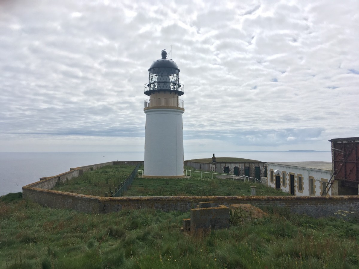
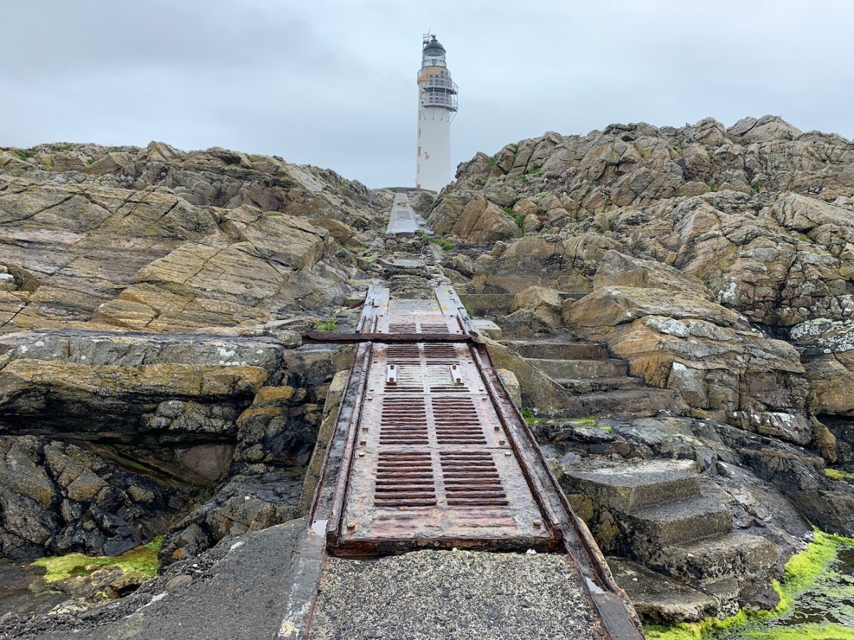
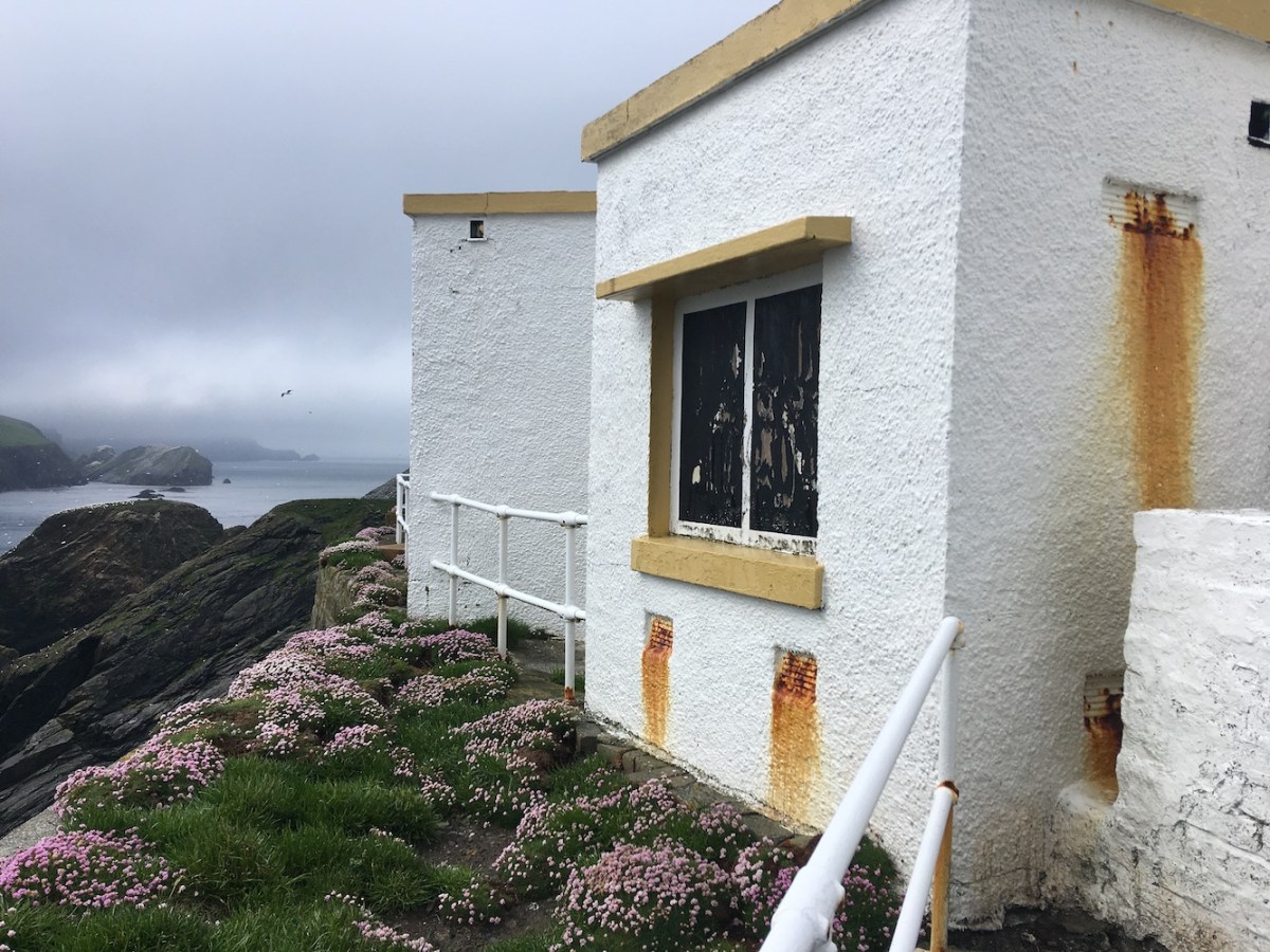
The buildings around the lighthouse are, unlike Auskerry (but again like Barra Head), looking very sad and neglected. We learned from the boatman that they are actually owned by different people, not all the Northern Lighthouse Board. It is such a shame to see it left like that looking so shabby, particularly when the lighthouse has recently been painted (for Princess Anne’s visit in the last couple of weeks). Still a wonderful place and definitely a major highlight for me today. The landing was ok, although there were some of the panels missing so you definitely needed to look where you were stepping. As we came back down to the boat I realised the tide had gone down a bit and I was worried we would have to go on the particularly dodgy bit of the landing area where bits are broken and missing all over the place, but it was fine.

Copinsay
Copinsay lighthouse

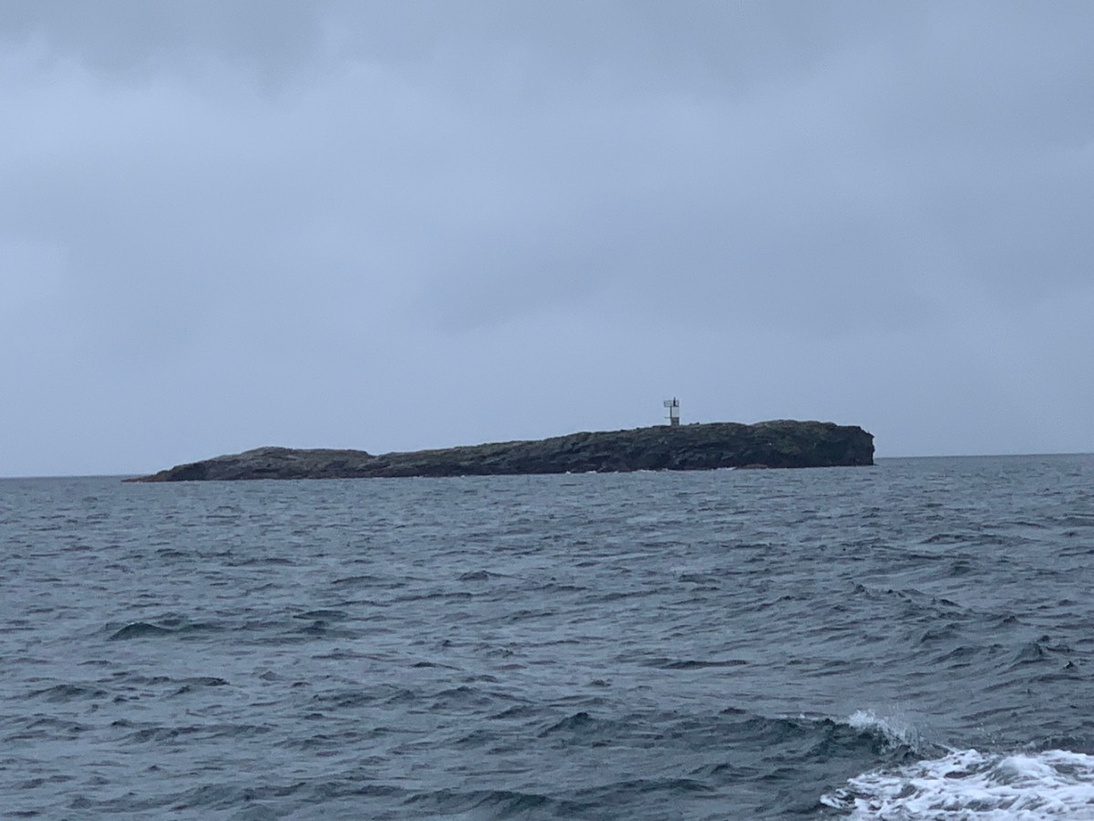
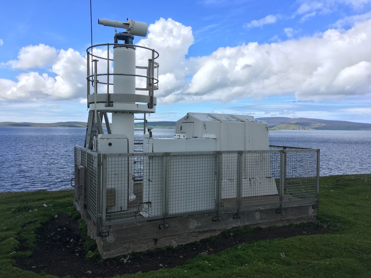
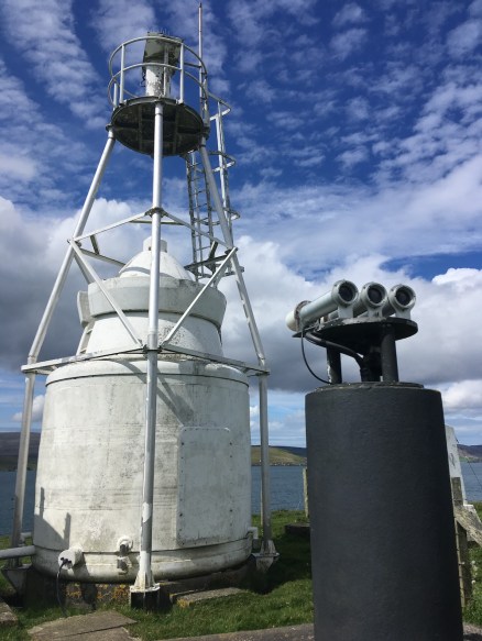
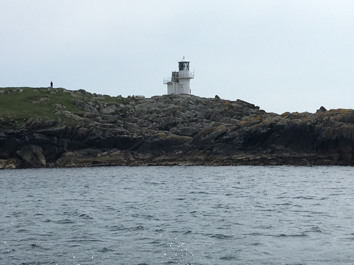
An added bonus was our final stop of the day. We were talking about the plan this morning and there was mention of Copinsay and possibly Swona (which we didn’t get to). Bob just happened to ask the boatman if he would be willing to go to the Pentland Skerries to land on Muckle Skerry and it was only Bob and I in the group who had been there before. The answer from Paul the skipper was that it would be fine. Nothing has been any trouble for him today at all, which is perfect. He had not been to or landed on Muckle Skerry before, so was quite interested to go there. The sea was so calm today and had continued to be so. Unsurprisingly, the roughest stretch was after we entered the Pentland Firth when it got more choppy. It was still fine, but you certainly noticed the difference. As we had been there before, Bob told the skipper where the landing place was, which made it a lot quicker. Landing was fine again, although a little slippy on the rocks to start with. The next section of the walk up to the lighthouse involved a large number of rocks in step formation, which was massively helpful for getting up to the grass. From there you have a nice stroll towards the lighthouse.

Pentland Skerries
Pentland Skerries

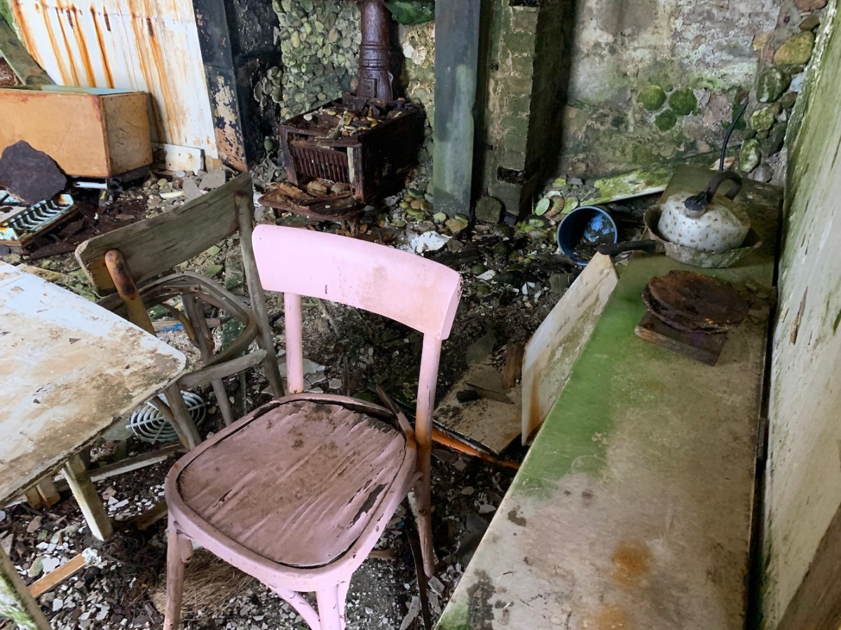
Some of the cottages have seen better days. One of the cottages had a door open so we checked to see if anyone was in before we slipped inside. I noticed on the mantlepiece that there was some sort of black board with the names of the Principal Keeper and Assistance Keepers. It had a date at the top: 1994. Having just checked online, the lighthouse would have been automated in that year, so those three could very well have been the last keepers at the lighthouse. I also walked around the walled gardens a bit to establish where the graveyard is, but I didn’t see it. I think we are all aware that the tide was dropping so we didn’t want to leave it too late in case the boat dropped too low next to the landing area. It’s a brilliant island. I could just do with a bit of a longer trip there to find everything on the island, which is bigger than it looks!

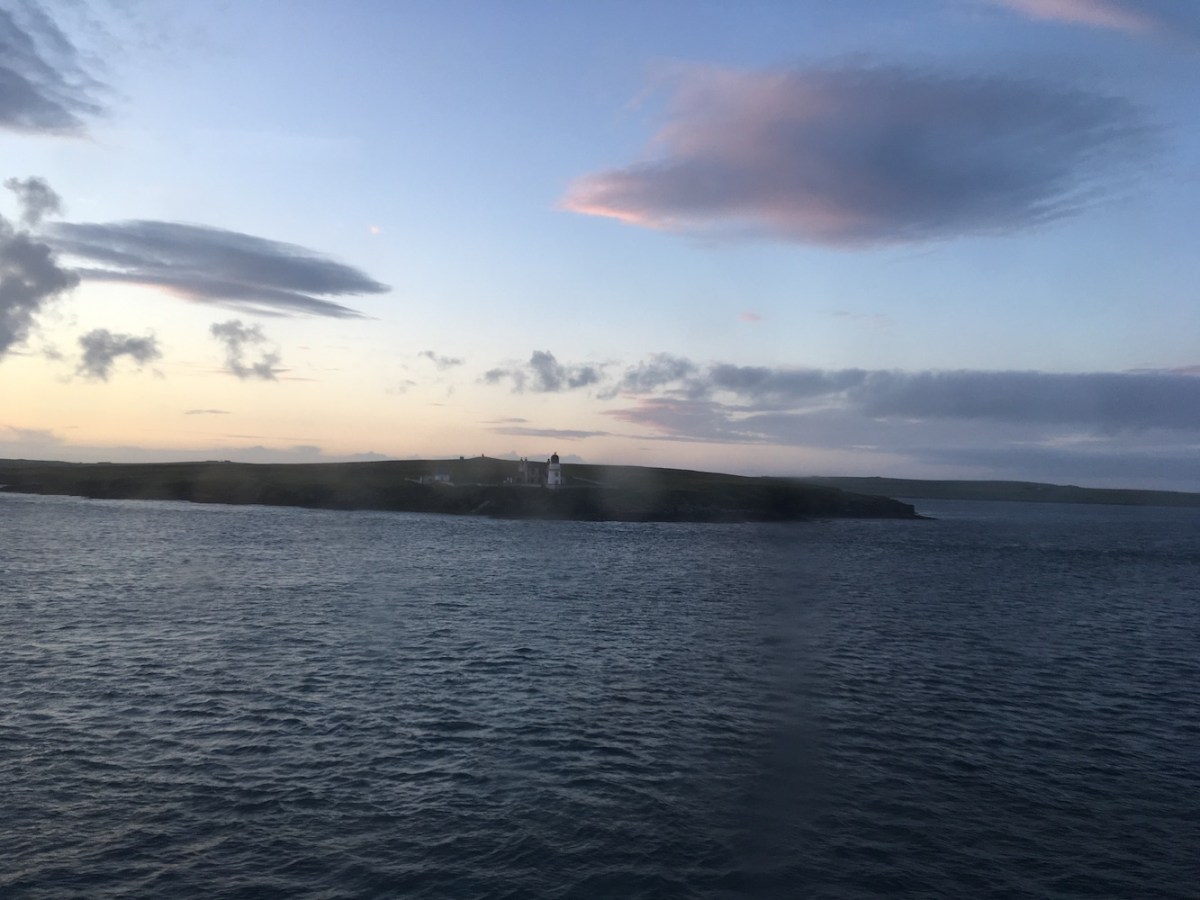
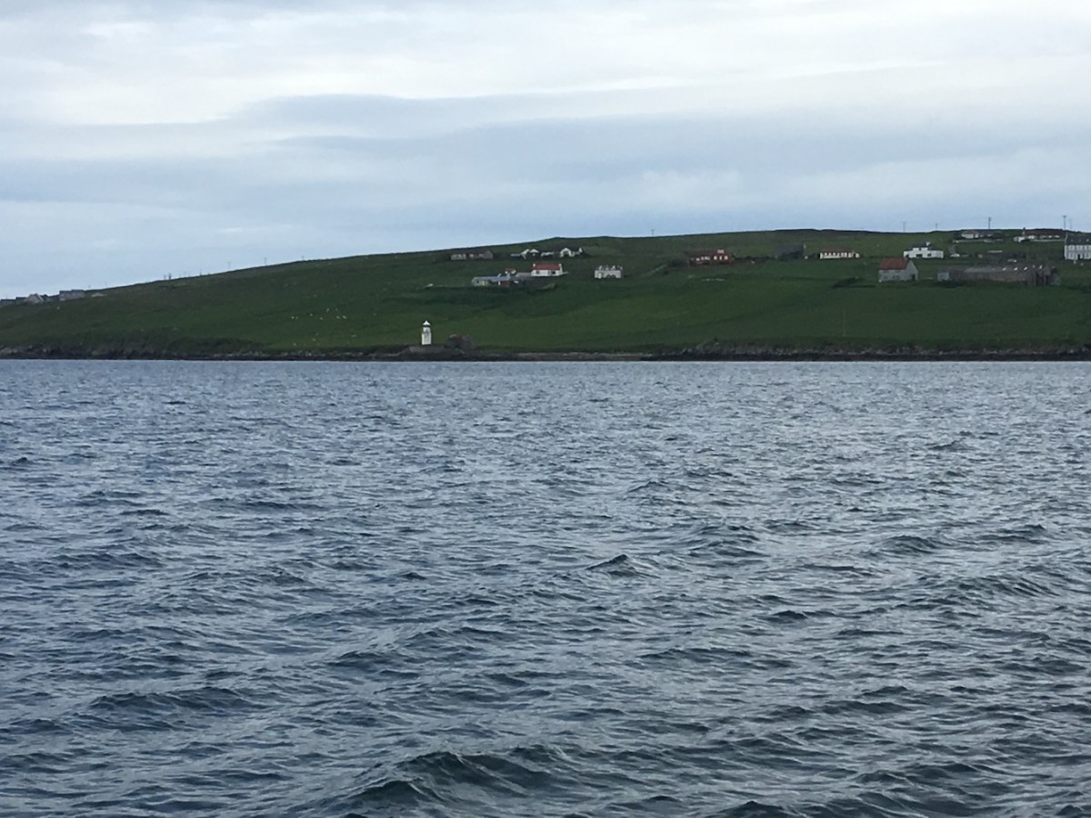
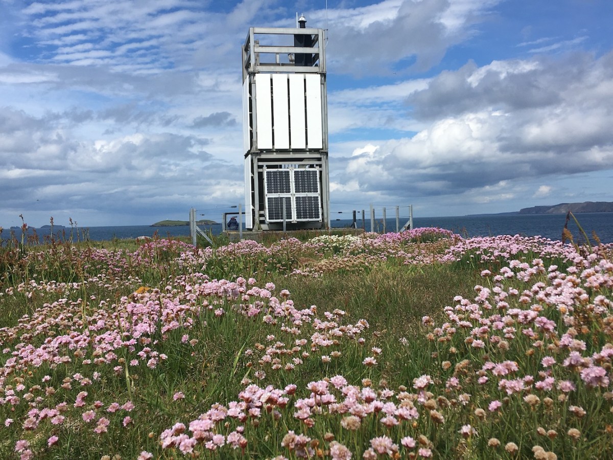
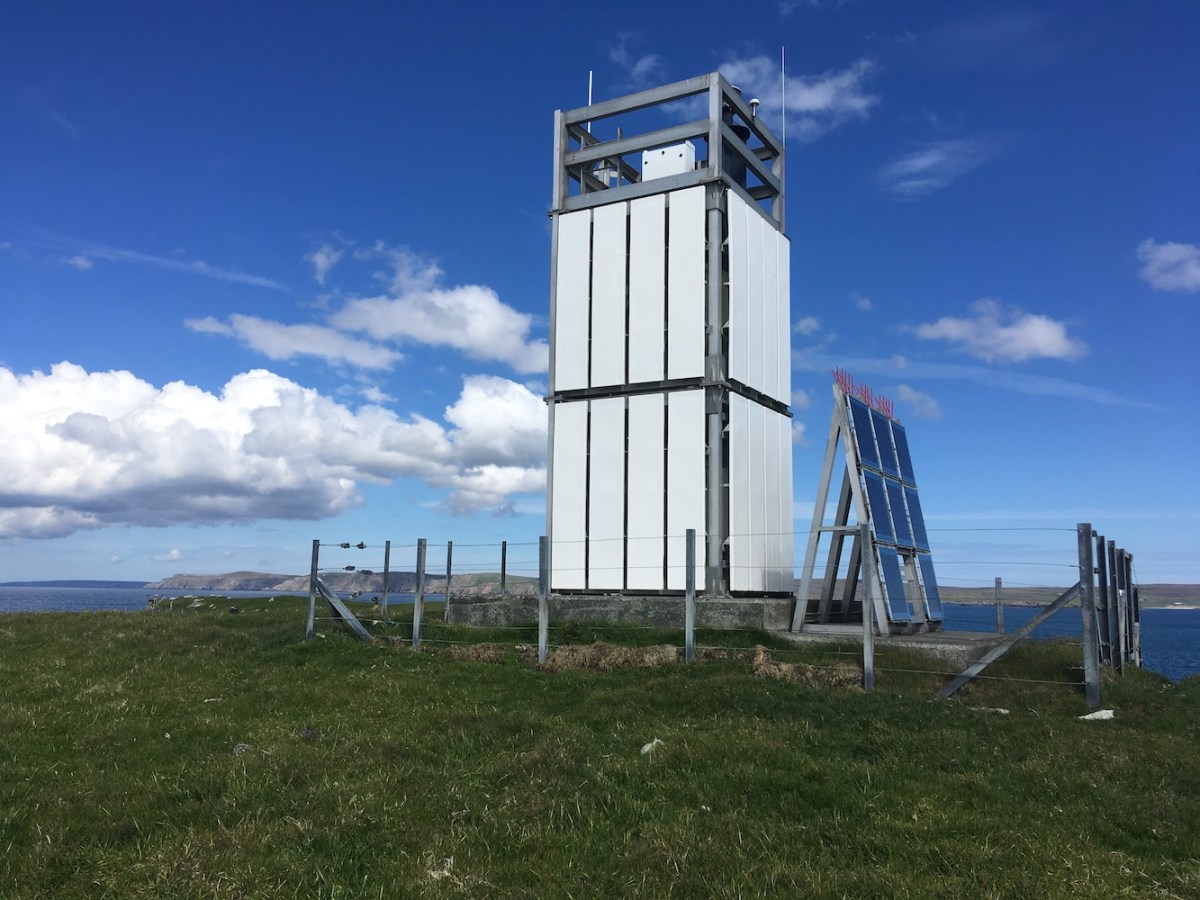
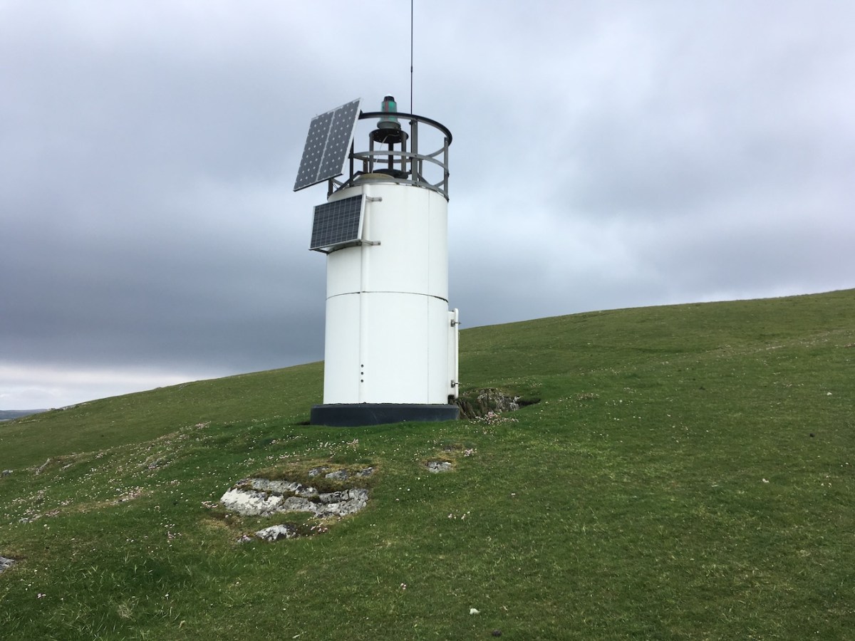
We all left Muckle Skerry feeling very happy with our achievement and the day in general. We did wonder if we could manage a visit to Helliar Holm on the way back to Kirkwall, but the tide had dropped a lot, so it would have involved some effort to have got up onto the slipway (for me anyway with my short legs)! We decided to leave it until first thing tomorrow when the tide will be higher. I was pleased to get close though as the light on it was amazing. I think it’s a beautiful tower anyway, but bathed in yellow-y light, it was even better.

Helliarr Holm
Helliar Holm lighthouse

Something fun to look forward to tomorrow after such a successful day today! 🙂

18 hours in Orkney

Another delayed post and this one follows on nicely from my Shetland Adventure last month.

After we’d booked our holiday in Shetland I was invited to present at the Scapa 100 event, marking the centenary of the scuttling of the German Fleet at Scapa Flow back in 1919, which still remains the largest loss of warships ever to have taken place on a single occasion. The talk was to be related to my forthcoming book, The British Lighthouse Trail: A Regional Guide. I was a little worried about it as all of the lighthouses were turned off during the war and only used when required by the Navy, so I wasn’t sure if it would be relevant to the subject matter, but I didn’t want to turn down the opportunity.

This invitation meant cutting the Shetland holiday short by a day, but it was easy enough to get from Lerwick to Orkney on the ferry and the best bit was that we would pass islands with lighthouses on them. When we set off from Lerwick it was the longest day so there was still plenty of light for being able to spot the two lighthouses at either end of Fair Isle on the way past. Fair Isle is very high on my priority list and I hope to make it there next year at some point. It’s a beautiful island from the sea and I’m sure it is equally impressive from the island itself.

Fair Isle
The perfectly formed Fair Isle

Also lovely to see from the ferry was Auskerry lighthouse, another one on my list. The ferry sails fairly close to it and I am now hoping to get out there next month – fingers very much crossed! Another one I have on my list for next month is Helliar Holm. Such a lovely little lighthouse. It’s a great shape and I enjoyed seeing this one from the ferry too.

Helliar Holm.JPG
Helliar Holm lighthouse with a midsummer sky – taken through the window

There was still a little light in the sky as we arrived in Kirkwall. I was particularly excited to see the Pharos, the Northern Lighthouse Board‘s vessel moored up in the harbour. Also part of the Scapa 100 event was the opening up of the Pharos in Kirkwall and their second vessel, Pole Star, in Stromness. I was even more excited about this as I’d managed to take a look around the Pharos in April and with the Pole Star being in Stromness, the location of my talk, I was hopeful that I would get a chance to get on board that one too during the day. I knew it would be touch and go as it was open from 1-4pm and my talk was scheduled for 2-3pm. I spotted the Pole Star in the harbour as I arrived in Stromness that evening and also got the pleasure of seeing both the Hoy High and Low lights on Graemsay in action.

The following morning I had a plan of what I was going to do before my talk. I had plenty of time to kill so I first set off to get a view of the Pole Star. It is quite a bit smaller than the Pharos, which I hadn’t realised before. As I was leaving the harbour I saw the ferry to Graemsay set off and felt very jealous of those who were going to spend the day over on the island. It is a great island and it would have been a perfect day for a trip over there.

Pole Star
NLV Pole Star

Being a little bit obsessed with Sule Skerry at the moment, following my visit to the island and lighthouse in May, I was very keen to pay a visit to the old shore station in Stromness where the families of the keepers lived when the lighthouse was manned. To get there meant walking the length of the main street through Stromness, which is never a chore. It’s got a really lovely feel about it and a lot of history too.

On the way along I was on the look-out for the old Northern Lighthouse Board depot. Until 2004 the Pole Star (not the current one, but its predecessors) was based out of Stromness and I knew that the old building and pier were still around somewhere. I was concerned that I wouldn’t be able to find them, but I need not have worried as I recognised the buildings straight away, mainly due to the distinctive quoins around the windows. While the quoins are a different colour to the current bamboo/biscuit/buff that is so common among Northern Lighthouse Board buildings, it was obviously the place I was looking for. The building has since been taken over by the local Council so I wasn’t so keen on wandering around the area, but the view from the main street was good enough for me.

NLB depot
The old Northern Lighthouse Board depot with the entrance to the old lighthouse pier in the background

A little further on was Stromness Museum, which was also on the agenda for the day, but didn’t open until 10am so I continued along the coastal road. Once I’d passed the buildings on the right the view opened up across Scapa Flow which was stunning in the bright sunshine. I imagine that stretch of water saw its fair share of divers during those 12 days of Scapa 100 events. I was so busy looking at the sea and ahead to try and see if I could spot the old Sule Skerry shore station that I found myself at the end of the road and, turning to look back, realised I’d already walked straight past it. I continued on around the corner and walked past the back of the building first. It always feels a little strange to be taking pictures of someone’s house, but then if you live in a place like that then you would probably need to get used to it. It’s a really big building, which isn’t surprising really when you think that it needed to house up to four families at a time.

Sule Skerry shore station back
The view from the rear of the Sule Skerry shore station

Walking back around to the front of the house I discovered the true majesty of it. It is amazing and its location is fantastic to look up at and, I imagine, equally impressive to look out from. It is very similar to the old shore station in Breasclete, Lewis where the families of the Flannan Islands keepers lived. I noticed the old Northern Lighthouse Board design above the door, which again is the same as the Breasclete building. There’s a wonderful garden in front of the house and then, on the opposite side of the road there is a little gate leading down the a small pebble beach. What a wonderful place that would have been to have grown up – and all the while your dad would have been out working on the most remote manned lighthouse in the British Isles. What a way to live!

Sule Skerry shore station
The former Sule Skerry shore station from the front

Not wanting to hang around too long taking pictures of someone’s house, I began the walk back towards the Museum. I arrived there to find that there was some filming taking place and I was told that I could either look around quietly or I could go back again in an hour when the filming should be finished. I decided to go for the latter and found a cafe to stop at for a cup of tea. An hour later I began to walk back and happened to bump into Mike Bullock, the Chief Executive of the Northern Lighthouse Board. I’d seen him give a talk about the Northern Lighthouse Board back in 2017 when we visited their headquarters in Edinburgh during the Doors Open Days, but never met him to have a conversation with. We chatted for five minutes, during which time I’m quite confident he established that I am very much an enthusiastic “enthusiast” when it comes to lighthouses, particularly Scottish ones. I also informed him that I was the one who tweeted about really wanting to get onto the Pole Star that afternoon (a tweet he had commented on the previous day). He very kindly gave me a Northern Lighthouse Board keyring and pin badge, we said our “hope to see you later”s and I continued on to the Museum.

The filming was still going on at the Museum, but I decided that I couldn’t delay my visit any longer. They have a wonderful array of lighthouse artefacts in there, particularly relating to the lights in Orkney. While there aren’t rooms and rooms dedicated to lighthouses they have certainly packed a lot of information and items into the area they do have for it. For anyone interested in lighthouses it’s a must visit place, that’s for sure. By the time I’d finished looking around the museum the filming had come to an end so I was able to speak to the staff there. They were particularly helpful as I was keen to get someone local to the area to help me with pronunciations of place names ahead of my presentation and they certainly did that!

Old Hoy lens
The original lens from Hoy Low lighthouse in Stromness Museum

Once I’d finished at the Museum I just about managed to find somewhere to have lunch (it was very busy) without needing to go back to the same cafe I’d been to that morning. I also took the opportunity to add pictures of the Sule Skerry shore station and old depot buildings into my presentation.

Walking back across to the venue I saw people heading over to the Pole Star and for the second time that day I was envious, but still held out hope that I would be one of them too. I was taken to the room I was presenting in and we managed to set up in time for the audience’s arrival. I was pleased to see that a good number of people had come along, but it did also make me slightly more nervous. From what I could tell the presentation went well. I’d focused it specifically on the lighthouse of Orkney and added in some information about lighthouses in wartime and war-related lighthouse incidents in Orkney. It was structured as a timeline starting with the old North Ronaldsay light and ending with Tor Ness (the last one to be introduced) and World War II. People seemed to engage well with it and asked a number of questions at the end – a couple of which I wasn’t able to answer (but I later put the same questions to Mike Bullock and he wasn’t sure either, so that made me feel better). A number of them also came up to speak to me at the end too, which was lovely.

It turned out that a lady who lives in the old Sule Skerry shore station was in the audience. She said that they would really like to restore the old Northern Lighthouse Board design above the door, but aren’t sure how to do so. She lives in a quarter of the building and is the only one to have kept most of the old fixtures and fittings as they would have been when the keepers’ families lived there. That would be amazing to see. She did invite me back for tea, which was really very kind, but I was on the late afternoon ferry so didn’t have time unfortunately. We happened to meet again on the Pole Star, which I did manage to get to in time!

As I mentioned before, it is a smaller vessel than the Pharos with no heli-deck, but still great to get onto. I was chatting to one of the crew and said “You must have been to some amazing lighthouses” and his response was that he can’t keep track of which ones he has and hadn’t been too, which seemed crazy to me, but then again I am a self-proclaimed enthusiastic enthusiast! After looking around the bridge I started speaking to another member of the crew. Unlike her colleague she is a massive fan of lighthouses and we spoke for quite a while about her adventures on the Pole Star, my lighthouse tour and the book, which she is really excited about. Her suggestion that I go on a world tour of lighthouses and take her along as an accomplice was a nice idea, although I’m not sure how I’ll fund that one! I was really pleased to have met her. If I’d had more time I would have carried on standing around chatting, but it was time for me to leave Stromness and Orkney and head back home.

On board Pole Star
The view from the bridge on the Pole Star

It had been a fantastic 18 hours in Orkney. I’d started out feel rather nervous and wanting to escape to Graemsay, but actually ended the day feeling glad to have been part of such a fantastic event. The organisers put in so much time and effort and delivered such a varied programme. I wished I’d stayed longer to see more of it, but I had to get back home to hide away and read through the draft of my book. I got a seaward look at both the old Lighthouse Board Depot and the Sule Skerry shore station as I said farewell to Stromness from the ferry.

Lighthouse pier and depot
The old lighthouse pier and depot from the sea

Another really positive and enjoyable experience in Orkney. I’m growing rather fond it that place. 🙂

A Shetland Adventure – part 10

This post is somewhat delayed due to other tasks taking priority (namely, the book and a presentation related to it – more on that soon!), but it marks the final of my Shetland Adventure series. Reaching double figures is fairly impressive and what a fantastic two weeks it was. The final bagging day was certainly a good end to a thoroughly enjoyable holiday. So, here is what occurred on the final Shetland boat trip…

Aside from the two lighthouses on Fair Isle, I only had one more of the big lighthouses left in Shetland to visit, and that was Out Skerries. I’d been informed by my good friend Brian that landing on Bound Skerry, the lighthouse island within the Out Skerries group, was straightforward and was only difficult on a few days each year. So I was fairly confident about it.

We went out with Seabirds and Seals from Lerwick and I think everyone was a little worried initially about how we might combine. They, of course, are far more used to taking the average tourists about on their lovely, comfy boat to see seabirds and seals, as their name suggests. We, on the other hand, are much more focussed on getting off of the boat and onto islands numerous times a day. It took us a little while to get used to each other, but it turned into a fairly efficient process once we were all settled in. One thing I particularly enjoyed was the number of cups of tea and biscuits we were offered on the boat. It’s a great little set-up they have – and clearly one of the benefits you get from going with a tourist-orientated crew. Earlier in the week I did manage to wangle a flask of tea from Kevin from Compass Rose Charters, the operator who landed us on Muckle Flugga, though while the others were busy doing their island bagging business.

So, back to Out Skerries. The journey out there was easy enough. I’m not used to being on catamarans, clearly, as it felt different. Not so bumpy, a bit more rocky, but it was fine. Unfortunately it was a bit of an overcast day with plenty of rain, but we were informed that it should clear up by the afternoon.

Out Skerries distance
Out Skerries lighthouse awaits

After dropping a few of the group on one of the two main islands, we headed around to Bound Skerry. We’d seen the lighthouse for some time before we arrived there and it was nice to finally be approaching the island. There were only 5 of us going onto the island so we did two runs across in the tender, landing onto slippery platforms and then walking up slippery paths to get to the lighthouse. That’s the problem with rain it automatically makes rock more difficult to walk on, but we arrived at the lighthouse without incident.

Out Skerries path
Looking up the path from the landing area

It felt different there than I thought it would. For some reason I expected there to be more life about in the Out Skerries in general, of course not on the lighthouse island, but there appeared to be no one about – although I must admit that I didn’t land on the main island of Bruray. It all felt a little deserted, and that’s not necessarily a bad thing. I think some of the most fantastic places I have been to are those where people once lived, but no longer do. It is certainly the case with a number of lighthouse islands, but there are others too.

Out Skerries and shore station
The lighthouse with the shore station in the background

The lighthouse is beautiful, and perhaps more so from a distance. It is wonderful to see it close up of course, but when you see it from further away (particularly from the neighbouring island of Grunay) it looks like it is nestled so nicely on the island, almost like it has always been there, as nature intended it to be. There is very little space on the island once you look beyond the lighthouse and helipad. You can see why they built the shore station for the keepers’ families on Grunay instead, although I have just discovered that Grunay was the location of the temporary lighthouse built in 1854 before the current tower was built on Bound Skerry in 1858. You feel very abandoned there, or maybe that was just because our boat went off to drop someone on Bruray and took longer to get back than we had thought! It was a great experience being there though and it’s definitely one of those inspiring places that, if I had the time, I might write some sort of story about. A very interesting visit.

I appeared to be the only one present to have known that Grunay, the next door neighbour island, was home to a little Shetland Islands Council lighthouse. As we approached it I was looking around towards the landing steps and knew exactly the view I was looking for, but just couldn’t see the lighthouse. It turns out that Grunay has a “dog leg” (I’m not sure that’s the right term, but I’m sticking with it). The small islet at the end of this dog leg is what I was looking for. It is separated from the main island by large boulders, which are tricky to navigate your way across – or at least that’s what I found. Whether or not the islet is tidal I’m not sure. I imagine that if it isn’t then in stormy weather the waves would crash over the boulders. Thankfully that day the sea was nice and calm.

Grunay
The lighthouse on Grunay

The little lighthouse on Grunay is similar to those at West Burrafirth, only it is round rather than square. It does have a Council look about it and it’s just tall enough to feature a door. We wandered around it in the long grass for a while before crossing back through boulder city. We knew we didn’t have a lot of time, but wanted to get to the old Out Skerries shore station. By this point I was pretty hot and I’d not had any lunch, so I wasn’t at my best, but as soon as I spotted the lighthouse peering up over the island I felt a bit better.

Out Skerries shore station
Out Skerries shore station (you can just spot the top of lighthouse above the roof)

The shore station, while still standing, has seen far better days. The windows and doors are all gone and nature has been left to do what it will to the buildings. I didn’t want to go far into the building as you never know what condition they might be in structurally, but I saw enough to feel a little sad about it. When you are seeing furniture in rooms where people once lived looking in such a bad way it does make you think. Ailsa Craig was the first one I saw,  but at least that one was being used (or should I say abused) occasionally by bird watchers. Here there has been no one since the keepers left the tower in 1972, when it became one of those in the first round of lights to be automated. Forty seven years without maintenance certainly takes its toll.

Out Skerries shore station internal
Inside one of the rooms at the Out Skerries shore station

The rain arrived just as we were walking back to the boat. Once we were back on board and attempting to dry out we went to collect the others who had been sheltering in the public toilets. Due to there still being a number of islands left to pick off on the way back to Lerwick, we only sailed past Muckle Skerry with no attempt to land. Muckle Skerry lighthouse is a flat-pack, and from the distance we saw it at and the conditions at the time it was considerably less inspiring than Out Skerries had been, but still a nice one to see.

Muckle Skerry
Our distant view of Muckle Skerry lighthouse

Our final lighthouse stop of the day was Hoo Stack. I had been informed the night before that: “Hoo Stack is called a stack, but it is anything but”, which I was pleased to hear. Landing on the island was fine, but it was then a bit of a clamber up among rocks and I was very kindly led by Alan while Bob helped with the landings. Alan had also led me up Gruney a couple of days before, so I am grateful to him (not that he will see this as he is a self-confessed techno-phobe). Once we were off of the rocks it was just a short walk up to the lighthouse.

Hoo Stack distance.jpg
Hoo Stack (or is it an island?!)

The lighthouse on Hoo Stack is another flat-pack, but quite an interesting one as it has three levels to it and the bottom level is missing the white cladding, which was very exciting as it meant I could physically get inside it. I’d been wanting to experience that for some time and managing it on the final one of my lighthouse islands of the trip was great. The sun had come out by this point too, which also increases your enjoyment of a place. Of course the others joined me inside the lighthouse too. I think they are really getting into this lighthouse bagging malarkey.

Hoo Stack
Hoo Stack lighthouse in the sunshine

A truly brilliant way to end the two weeks in Shetland. Reflecting back on it now, it seems almost like a dream, as if it never really happened, but it certainly did. The highlight though had to be Muckle Flugga, of course. After that I can’t even begin to pick out the best bits – there were far too many of them. 🙂

A Shetland Adventure – part 9

Every now and then I have a day involving lots of little lights and today was certainly one of them. We spent the day on a boat with Compass Rose Charters (who landed us on Muckle Flugga the other day) in Yell Sound, Shetland. I’d been looking forward to this one as there are plenty of small lighthouses on the approach to Sullom Voe. Some are Northern Lighthouse Board while others were installed by the council.

Our departure point was Toft on Mainland Shetland. First we headed out to the islands of Linga and Samphrey, which gave us a nice view of Firth’s Voe, which we’d walked to the other day.

Firths Voe
Firths Voe from a distance

From Samphrey we set off for the Sound and immediately you begin to spot little white towers around. The rest of the group wanted to get onto a couple of the islands on the east side of Yell Sound, which gave us an opportunity to see the Ness of Sound lighthouse, another one we had walked to during this trip.

Heading towards Brother Isle we could see Mio Ness, which is on the Mainland to the north east of Sullom Voe. Brother Isle was our next stop. By this time the sun had come out. Although the light on Brother Isle has no possible internal access to the tower itself I was still interested in seeing it as we were going there anyway. It’s a fairly interesting structure with a few little additional boxes around it. I’m glad I went to see it anyway.

Brother Isle
The light on Brother Isle

We sailed close to the light on Tinga Skerry. This one appears to be typical council style with the circular white tower made up of panels. The sun began to shin on it just as we were passing, which always has a way of making any structure look better than it otherwise would.

Tinga Skerry
Tinga Skerry lighthouse

Lamba was our next stop and this was a very interesting one. Not like any I had seen before. Next to the tower was what looked like three little gun barrels lined up. I’m pretty sure they are actually some sort of sector lights, so not quite so dramatic. It was a bit of an uphill walk to get to, but the blue sky in the background was great and it was nice to see something a bit different. It was a bit of a scramble on the rocks to get up, but not too bad.

Lamba
Lamba lighthouse

Little Holm was next on my hit list. It’s a tiny island really, but very beautiful. It is covered in patches of thrift and is also relatively low lying so no hills, no bonxies, just a lovely little place. It’s a Northern Lighthouse Board flat-pack but, as with so many of these, it’s the surroundings that make it so enjoyable and that was definitely the case here.

Little Holm
Little Holm lighthouse

It’s neighbour to the north, Muckle Holm, was steeper, but most of the height gain was done before we even left the rocks. This one has a far more dramatic coastline with a couple of big geos to look down into as you walk to the lighthouse. Again it’s a standard flat-pack.

Muckle Holm
Muckle Holm lighthouse

As we continued north we began to see the Point of Fethaland lighthouse, yet another we had paid a visit to on this holiday. It looks very small up on the high cliffs. I think I preferred seeing it from the land!

Our destination was the island of Gruney, which sits off of the coast of Point of Fethaland. We had seen the lighthouse on our visit to the Fethaland light, but now it was time to get onto the island and see it close up. This was where it got a bit interesting. All day we’d had flat calm landings on to dry rocks. Due to the direction of the wind and swell we needed to land on the east of the island. There was a relatively sheltered area, but the only problem was that we would be landing on a sloping slab of rock covered in seaweed with no easy place to go to avoid it. We were also struggling a little with the swell, which was moving the boat a bit as people got off. Fortunately Bob and a couple of others had micro spikes with them so Bob was able to land and stomp up the slab to hold the rope. When one of the group slipped on the seaweed I thought “I’m not sure I want to do this”, but a couple of them told me it would be ok so I got off of the boat and clung on to the rope while I shuffled my way up. Once we were past the worst of it one of the other group members helped to guide me up the rest of the rocks. You might think that I would have been relieved to have reached the top, but I was already worrying about how I was going to get back on the boat. I was, however, rewarded with some incredible views in various directions. Firstly the lighthouse was another interesting type. I was surprised to see a Northern Lighthouse Board plate on it as I’ve not seen any of their structures looking like this before. It made me question whether the Lamba light was also something to do with them, although it didn’t have a plate. The views across to Point of Fethaland were great, but the most impressive view was towards the array of sea stacks and a natural arch to the north. It made the effort to get there worthwhile. Getting back onto the boat wasn’t as bad as I’d expected. Bob leant me his micro spikes and the combination of those and holding the rope again made me feel much safer. I was still glad to get back onto the boat though!

Gruney
Gruney lighthouse with Point of Fethaland in the distance

On our journey today we spotted a small white and orange tower on the island of Little Roe. It looked similar to the front light of the nearby Skaw Taing range so we felt it was important to get a closer view in order to judge whether or not it was the type that had internal access. On our way back down to Toft the skipper agreed to travel via Little Roe to give us a closer view. Looking through the zoom lens on the camera it was clear that it was the twin structure to the Skaw Taing Front range light. This was one I had not previously had on my list so I’m glad I found it today. As I said towards the beginning of this post, Yell Sound has plenty of lights.

Little Roe.JPG
Little Roe lighthouse

A really enjoyable day and a very successful one for getting to some of the lights I would otherwise only have seen from a distance. 🙂

A Shetland Adventure – part 8 (the best day)

I’m not even sure how to begin this post really, so I’m just going to dive straight in there and say it. Today was the day we landed on Muckle Flugga!

I’m sure many of you will know it already, but if not then Muckle Flugga is the most northerly lighthouse in the British Isles. It is perched beautifully on top of a big rock a short distance off of the north of Unst in Shetland. Interestingly the lighthouse did, in its early days, used to be known as North Unst. It is renowned for being difficult to land on and fairly wild in terms of sea state and weather.

Last week we took a drive up to Saxa Vord with the kids and my parents to see if we could spot the lighthouse. After the fun we had with trying to do that last November I thought it might be difficult to see again, but fortunately the cloud was high and the sun was out. We joined a number of others in looking across at it. My dad had taken his telescope so I was able to get a closer view without actually being closer. That afternoon we went to Unst Heritage Centre, which has a small but incredibly interesting exhibition space dedicated to Muckle Flugga lighthouse. There’s obviously a lot of local knowledge, experience and information there and it gives a great picture of the human side of the lighthouse with the keepers and boatmen. It’s well worth a visit for anyone interested in the lighthouse.

MF through telescope
Muckle Flugga lighthouse through a telescope

I should point out before I get too carried away with today’s trip that the Northern Lighthouse Board do not advise anyone lands on the island and we approached it fully accepting that we were doing it at our own risk.

Back to today’s trip, we had known since early last year that an attempt to land on Muckle Flugga was on the agenda for this two-week stint in Shetland. While I thought that two weeks in June would maximise our chances as much as we possibly could, I never really believed we would manage it. The boatman was hesitant to take us there for a start. He obviously knows the area well and understands that landing there is a rare occurrence. We went out with him on a trip last week and through conversations I had with him it seemed unlikely that we would even attempt it. One thing that did work in our favour though was that the skipper got a chance last week to see just how capable the group are of carrying out tricky landings. I’m not necessarily talking about myself. In fact, not at all, I tend to be helped a lot by my very able companions.

A few days later, yesterday in fact, we received a message from Alan who is organising the trips to say that the first Muckle Flugga group (which included us) would be going today and the forecast was also looking good. It was all sounding positive, but I wasn’t going to get my hopes up to much, just in case.

It was a fairly calm journey up the west coast of Unst, which was encouraging, but of course we had the shelter of the island on our side. The wind had moved around to the south east and the skipper had said last week that any wind/swell from the north would make it impossible to land – another thing in our favour.


MF from sea2
The view from the sea

Around 50 minutes into the trip the lighthouse came into view. The sea still didn’t seem to be too bad and I did think that perhaps we may well be able to do it. This was confirmed about 10 minutes later when we arrived near the landing and the skipper gave a positive indication that we would give it a go. There was still movement in the sea so we moved to the slightly sheltered north west side of the island to unload into the tender. Bob hopped into the tender along with Brian who has experience of landing there. I asked if I should go in the first run too and in I hopped, well slid really as it was a bit of a drop from the main boat into the tender (as I was to find when getting back into the main boat afterwards)! It was a bit splashy on the way to the island and I tried not to laugh too much as the others got splashed full in the face.

MF distance
The view from the sheltered side

Arriving at the landing place we knew we would need to go up the old steps as the new steps have been removed in places. Bob leapt off of the boat with his micro-spikes on to pull the boat in. The landing on a flat piece of rock was fairly straightforward, but it immediately got slippery for those of us not wearing micro-spikes. There were plenty of steps ahead of us (246 in total I was informed), but we took it slowly and a short time later we were there at the top with the lighthouse in front of us.

MF front
Muckle Flugga lighthouse

It’s astounding to think how the lighthouse and all of the associated buildings came to be here. It’s not even a particularly basic layout for a lighthouse complex. There are more buildings than there are at some other, much less remote lighthouses. How you would look at a big rock like that and think “I need to build a lighthouse there” without also thinking “Where on Earth do I even start?” I don’t know.

MF sector
The old sector light building

In the main courtyard there is the tower and attached buildings along with an old store room as well as a small square building that once housed an old sector light pointing eastwards. This sector light operated until it was replaced by a new light on Holm of Skaw, further around the coast to the south east. On the far side of the tower, just outside the compound, was the helipad and beyond this you could wander downhill slightly to another very small building. Apparently this was used at one point for keeping the Muckle Flugga resident chickens in! Just down the steps from the helipad was a great place to see the local puffins and fulmars from.

MF and helipad
The lighthouse and helipad

The views from the top of the rock are stunning. The low cloud was still rising in the distance when we were first there so there were the tops of a number of the nearby stacks with their heads in the cloud. We could also clearly see across to Out Stack, the most northerly piece of land in the UK, or as the promotional leaflets will tell you ‘The full stop at the end of the British Isles’! Standing on Muckle Flugga feels like a real achievement. The height of the island, the location and everything else bundled together is extraordinary. I found myself singing a lot while we were there, which is a sure sign of excitement.

We’d been brought across in three loads (I think, although I wasn’t paying too much attention to the others at that point) and the final group had a little more trouble with landing. It was becoming clear that we couldn’t spend much longer there without the swell picking up too much, so we began to make our way back down. I may have enjoyed the steps slightly more if they hadn’t been so slippery with some half covered in grassy tufts which seemed to be growing out of the stone! Getting back into the tender was fine, but the journey back was a little wet. The tide was changing and going against the wind, which was making things a bit more interesting. As previously mentioned, I just about managed to clamber back up into the main boat and enjoy the feeling of having been to such a challenging and inaccessible lighthouse.

MF steps
Some of the 246 slippery steps

Bob and a couple of the others were keen to land on Out Stack while we were there. If I was more able to bound about onto and off of rocks then I would have gone too just to be able to say that I’d been to the top of Britain. The skipper was concerned that there was only a short window of opportunity left to get them on the stack before the swell got too big. After a while looking for the best place to land the three of them got onto the stack and successfully reached the top. Getting them back onto the tender was a bit more interesting as they leapt in. At one point I think we all thought one of the guys had gone into the sea, but he emerged out of the boat. Bob was the final one off and leapt like a gazelle onto the tender, as he does!

The others landed on a couple of other islands/big rocks in the area so we were able to gaze lovingly at Muckle Flugga and its lighthouse for quite some time. One of these islands (just south of Muckle Flugga) was Cliff Skerry from which Bob took the most amazing picture looking across to the lighthouse.

MF from Cliff Skerry
Muckle Flugga from Cliff Skerry

What a fantastic place. I feel the same as I did with Sule Skerry and the Flannans, which is something along the lines of “was I really there?”, but I most definitely was and it may sink in at some point. What a place. 🙂

A Shetland Adventure – part 7

Today has been about quality over quantity. When it comes to the lighthouse on North Havra, many would argue that quality is not quite the right term for it, but I would disagree.

The lighthouse on North Havra is particularly difficult to see and not easy to get to either. Many of the lighthouses in Shetland can at least be seen from somewhere, but this one is different. It’s position on the island means that there is only one place that you can see its light (not the tower) from and that’s only on a clear night.

North Havra was one of eleven islands to be visited by the boat that had been chartered, the Silver Swift, operated by Shetland Sea Adventures based at Hamnavoe. Hamnavoe was a fantastic place to sail from, mainly because we could gaze across at the beautiful Fugla Ness lighthouse. What a wonderful lighthouse that one is. We didn’t quite sail right past it on the way out, but it was still nice to see it from the sea.

After a couple of other islands we arrived at North Havra. Thankfully the sea was calm today and the boat was well set up for getting into (and out of) the tender. So it was a relatively easy hop onto the rocks to get onto the island. As soon as we were off of the rocks we were heading up a particularly steep slope. For an island that’s fairly small it’s rather hilly. I was, of course, on bonxie alert and sure enough there were a couple circling – although Bob initially tried to tell me that they were gulls. It wasn’t long before we arrived at the lighthouse. As expected, the structure is very similar to that at Point of the Pund. It’s a fairly basic GRP tower with a light on top. I was pleasantly surprised to see that the rest of the group had decided to make the effort to go and see it too.

North Havra1
North Havra lighthouse

It turns out that the lighthouse really is hard to see from many angles. Even as we sailed around the island we couldn’t see if for quite a while. Once we were to the south of the island we could see it, but only until it disappeared behind another island.

A bit later, as the others were about to go onto another island, Bob pointed out Point of the Pund lighthouse, which we’d been to earlier in the week. On the way back into Hamnavoe Marina we got a closer view of Fugla Ness. It really is a beauty that one.

Fugla Ness
Fugla Ness lighthouse

So, the elusive North Havra was achieved and I am very pleased. Another success story from our Shetland Adventure. 🙂

A Shetland Adventure – part 6

I’m clearly on a roll here in Shetland. Today has involved visits to three more of the smaller lights on Mainland and Yell.

On Monday’s boat trip we could see the lighthouse at Whitehill, near Vatsetter, on Yell from a distance. Today was the day that we were going to attempt to get even closer. It was an overcast morning with a bit of rain in the air, but you can never let that stop you. After all of yesterday’s rain I thought it might have topped up the bogs a bit just to make them a bit more hazardous.

We parked up at Vatsetter towards the end of the public road and set off across the field. Although we could see the lighthouse at the start of the walk I knew that it was further than it looked. The ground was boggy in places, but not too bad as long as you looked where you were walking. There were a few leaps across damp channels, but that was it really. We headed down towards the beach and decided to follow the coastal route, which clearly caused a little distress to the nearby arctic terns and oystercatchers, but I told them ‘we come in peace’ in the hope that it would make a difference – it didn’t. There were a couple of old ruins by the shore and the remains of an old wrecked boat lay on the stones nearby. The walk was interesting enough that it didn’t seem like long until we arrived at the lighthouse.

Whitehill shipwreck.JPG
The shoreline and wrecked boat near Vatsetter

Whitehills lighthouse is a flat-pack affair and it has the usual solar panels that accompany this kind of structure. One thing we noticed about the solar panels was that they had a thick sheet of perspex over them, which may be an indication of how wild it can get there. It was certainly rougher around the coast there today than it has been in recent days with the wind having moved around to the south east. It was nice to see the location of the old Whitehill tower, which can now be found (painted red) at the side of the road on the approach to Arbroath.

Whitehill
Whitehill lighthouse

On our way back to the car we went cross country a bit more until we spotted some bonxies, which are fast becoming the bane of my Shetland lighthouse bagging days. They didn’t appear to be too aggressive, but we made our way back towards the coast just to steer well clear of them. Once again the terns and oystercatchers “welcomed” us on the way back and only a little while later we were back at the car. I remember looking at the OS maps and the locations of some of the lighthouses in Shetland last year and thinking ‘how on Earth am I going to manage to get to all of them with the distances and terrain’, but over the last few days I’ve realised that not all of them are so inaccessible. I’m not going to lie, there are a few that instil a sense of dread in me at the thought of it, but not so many as there were last year.

After stopping for lunch in Mid Yell, we moved on to our next endeavour, reaching the Ness of Sound lighthouse. I’d seen this one a number of times as it is visible from the main road in Yell as you travel north. It sits on a ‘tied island’, also known as a tombolo, in Yell Sound. Fortunately the sun had come out during lunch time so we were greeted with a beautiful view after we parked up in a lay-by on the main road to the north of Ulsta. It was fairly steep walking down the track which passes alongside a house. It’s always a little unnerving walking so close to someone’s house, but it appeared to be deserted. A great location for a house, just a stone’s throw from the two strips of land that lead you over the the Ness of Sound. It is, in fact, a double tombolo because it has these two strips rather than just one. We opted for the stoney stretch to cross over to the island that’s not really an island. It was fairly steep walking up the grassy, bogginess on the other side, but fortunately not too far before Yell Sound opened up in front of us.

Ness of Sound
Ness of Sound

The lighthouse beckoned, as they so often do, so we wandered down to it. Again it was a flat-pack and most definitely one with stunning views. As we walked down a lone bonxie lingered around a short distance away, but he/she flew off before we reached the lighthouse. There were wonderful views from every side of this one and after a while I sat down with my dad on the rocks in front of the tower taking in the view, while Bob looked into the intriguing concrete “lava spill” (as we called it) on the rocks, which also contained some old rope leading down to the sea from the lighthouse. We could see all the way up to the Point of Fethaland today and I imagined it would have been a wonderful day to have been up there, but Ness of Sound was certainly not a bad alternative. We eventually dragged ourselves away and headed back.

Ness of Sound lighthouse

Our final stop of the day with Firths Voe. We’d seen it from a distance on our last visit in November, but obviously wanted a closer view. We parked up at the side of the road and wandered down into a farmyard before passing through a couple of gates and then crossing a field down to the lighthouse. To me this is a very recognisable lighthouse. I think it is partly because the ruins of an old building sit behind it and that makes up part of its profile.

Firths Voe1
Firths Voe lighthouse

We upset a few gulls and terns here and my dad was quick to point out that one of my “favourite” birds was flying over. I don’t think I’ll ever get used to bonxies, I don’t think you can really. I’d had enough of the “bonxie fear” today so it was lucky that there was only one and it flew off as quickly as it had arrived. What I like most about Firths Voe lighthouse is that it is still going strong when so many others of its kind have been replaced by flat-packs (not that I have anything against a flat-pack, of course). From memory, the last few of this kind that I had seen were the old Muckle Roe tower near Sumburgh Head and the former Sandaig Islands tower which is now in Glenelg. The latter two are no longer operational so it is fairly rare to see one of these still doing what it does best.

Firths Voe2
Firths Voe

The tide was out while we were there so we could walk around on the rocks and get views from the full 360 degrees. It looks wonderful from every angle. I was a little disturbed to see that the land and rocks on which the concrete base of the tower sits appears to be wearing away underneath and I hope this won’t continue or have any impact on the lighthouse. We also spotted a little pier nearby, which was presumably set up to serve the lighthouse from. It’s a beautiful place and although the tower is relatively new in terms of lighthouses, it is great to see that the last generation of Stevensons were successful at building long-lasting towers just as their ancestors had been. Once hundred and ten years down the line it’s standing proud, just as it should be.

Firths Voe3
Firths Voe from the seaward side

A great bagging day and definitely a few lighthouses to remember. 🙂

A Shetland Adventure – part 5

Today’s instalment of the Shetland Adventure took us over to the west coast of Shetland Mainland, and the island of Muckle Roe. Muckle Roe is attached to the mainland by a bridge, which is helpful for achieving a visit to the lighthouse there.

We parked at the “car park”, a little lay-by at the side of the road and set off. I was delighted to see a signpost saying “Lighthouse 2km”, mainly because I knew it was a flat-pack lighthouse and I’ve never seen a signpost specifically guiding you to a flat-pack before!

Muckle Roe sign
The flat-pack lighthouse sign

Those 2km were a beautiful walk. We went a little awry initially on the walk and ended up losing the path, but we quickly found it again. The path near enough followed the coast along, with plenty of lovely views, particularly the one in the picture below. I thought that one of the rocks jutting out into the sea here looked like an alligator.

Muckle Roe coastline
One of the incredible views – can you spot the alligator rock?

There were lots of ups and downs and this way and that way as we went. At one point we came to a loch with a lovely little stream leading into the sea. It was a really interesting walk. After a while, when it looked like we still may have had miles and miles still to go, the lighthouse came into view, tucked down at the coast. It looked like we were nearly there until I got a bit closer and discovered that we still had to go a bit further inland to get out to the lighthouse. It wasn’t so far though and the old handrail posts reassuringly led us in the right direction.

The lighthouse is surrounded by an array of rocky outcrops and the cliffs in front of the tower are amazing. As my regular readers will know, I am rather partial to a flat-pack lighthouse and this was a standard one. As with so many of them though it is in part the location that makes them so worth visiting. Would I have wanted to miss out on seeing the great views I got on Muckle Roe this morning? No, I wouldn’t, and if it hadn’t have been for the lighthouse I would have been very unlikely to have gone there. This is what it’s really all about – well, that and the lighthouses too of course.

Muckle Roe from landward
Muckle Roe lighthouse

Knowing that a old lighthouse on Muckle Roe is now next to the car park at Sumburgh Head, I wish I had been able to see it in its original home. People talk a lot about the full-time lighthouse keepers – and very rightly so – but what a wonderful job the person responsible for looking after the old lighthouse here would have had. Take a flask of tea along and sit outside the tower, which was built as an automatic station, on a nice day (I have a wonderful imagination, can you tell?) and enjoy the beauty of it all. A wonderful thought.

Muckle Roe from coast
Looking up at the lighthouse

With the jagged coastline and land around it there are plenty of angles to see the lighthouse from. There was also an interesting little stone hut – or the remains of one – not far from the lighthouse. Not sure what that would have been for, but again a fantastic place to have a hut. Eventually it was time to head off and the walk back was straight forward with no wrong turns taken. The rain started just as we arrived back at the car so our visit was perfectly timed.

This afternoon we finally made it to the Shetland Museum & Archives, which we’d unsuccessfully attempted to visit in November. I knew that it contained the old light mechanism from Bressay lighthouse, which is exactly where I went as soon as I arrived. It is a catoptric mechanism, using mirrors to reflect light rather than glass, which was installed in the Bressay tower in 1940. When the light was automated in 1989 the mechanism was removed and, of course, it is now on display for all to see, which is wonderful. What is most wonderful though is that they have set it up so you can press a big yellow button and it turns as it would have done in the lighthouse.

Bressay mechanism
The old light mechanism from Bressay lighthouse

It was great to see this sort of light mechanism in action and because of the mirrors you also get to see yourself upside down as it spins! It’s fantastic what they have done with it. A real centrepiece to the Museum – or at least that’s what I think anyway. 🙂

A Shetland Adventure – part 4

Well, what can I say about today except that it has involved possibly the best lighthouse-related walk I have ever done. We decided that today, when the wind was strong from the north, to walk to the most northerly point of Mainland Shetland, the Point of Fethaland. Sounds like a recipe for disaster, doesn’t it? In fact it was incredible.

I was joined by Bob, my dad and our friend Mervyn, an island bagger. I was a little confused as to why Mervyn was interested in going to the Point of Fethaland as I just expected it to be a headland with no associated islands, but I was to find out exactly why Mervyn wanted to go there.

We parked up near the farm at Isbister and off we set. Once through the gate we had a choice of turning left or right. It turned out that a left turn would have taken us along a track all of the way, but we spotted cows up that way so turned right. Turning right meant we were taking the “off piste” route and we were wandering across fields and weaving our way over and around the wetter sections of grass before we rejoined the main track, which was basically a road. We spotted the island of Muckle Holm and its lighthouse off to the east on the way. The road petered out into more of a land rover track as we headed downhill and began to get the first views of the lighthouse and passed the old houses.

First view of PoF
The first view of Point of Fethaland

I was surprised at the number of houses, but it turns out the area was once a busy area with a deep-sea fishing station. Sixty boats operated here in the late 19th and early 20th century. These boats were manned by seasonal workers who shared the lodges of which there are believed to have been up to 36. It’s hard to imagine now that it was once the busiest deep-sea fishing station in Shetland. We didn’t see another soul on our whole journey.

Old houses
Some of the ruins of old houses in the area

As we approached Fethaland it became clear why Mervyn was interested. Fethaland itself is an island, albeit only at certain tides or in particularly wild sea conditions. As we walked across the rock and stones that divide the mainland from Fethaland it was fascinating to see the huge rocks to the west with waves crashing while to our right was a pebble beach with calm water in the sheltered natural harbour. Once we crossed the rocks it was a fairly steep walk up the island. At one point we ended up walking along a sheep track which ran along the side of a steep hill. Due to the wind I found myself stopping every couple of minutes until the strongest gusts passed before continuing on. Otherwise I could imagine myself tumbling sideways down the slope. One final push up the hill took us to the lighthouse and an absolutely stunning landscape opened up before us. As we went up, Bob had been to the high point of the island and I saw him climbing rather precariously up onto some rocks – not ideal in strong wind, but when he showed me the resulting picture I understood why he’d been up there.

PoF3
Bob’s view from the precarious rocks

The lighthouse is fascinating. I’ve not seen one like it before. It has a concrete base with a GRP section, containing the lens, on top. The lens was spinning away in the lantern. The black panels on the outside of the tower make it look much more modern than it actually is – it was first lit in 1977. Mervyn was delighted to have made it to the lighthouse too and said that it was his favourite and was beautifully engineered. As a former professor of engineering that is quite a powerful statement. I was pleased to have been there with him and that he is very swiftly coming around to this lighthouse bagging concept.

PoF1
The unique Point of Fethaland lighthouse

From Point of Fethaland we could also see the island of Gruney to the north, which boasts a small lighthouse. With the wild winds the sea was looking pretty choppy, which added to the awe-inspiring atmosphere of the place. It’s truly beautiful and in a really special place.

PoF and Gruney
The lighthouse overlooks the island of Gruney

After we’d spent a reasonable length of time there we started our journey back. It was all going so well until Bob (our guide) decided to climb up a nearby hill and we ended up missing a gate and needing to climb over a fence. All was fine though and we all made it back safe and happy to have been to such a wonderful place. This was certainly one of those days when you are glad to be a lighthouse bagger. 🙂

A Shetland Adventure – part 3

Today has been a long day with many hours spent on the Compass Rose run by Muckle Flugga Charters, but I was able to visit a lighthouse that I would otherwise never have reached. I waited on board while the others in the group did their islands. There were no easy landings today like we had yesterday on Linga and Vaila so I thought I would stay on the boat until we got to the island of Balta.

We passed the lighthouse on Balta before we landed so I could see that the terrain was very easy going and it would be a nice stroll across. Landing on the island was fine with just a very small clamber onto the rocks initially. Bob had very kindly offered to walk to the lighthouse with me before heading off for the high point. As expected the walk was straightforward with no obstacles at all. It was all rather pleasant really.

Balta Sound1
Balta Sound lighthouse viewed from the north

The lighthouse, as is common in Shetland, is a flat-pack, but it has not always been. The original tower that stood here was built in 1895 and designed by David Stevenson, the last generation of the lighthouse Stevensons. It was believed to have been one of the first concrete structures in Shetland. Having seen an old picture of it on Geograph, it looks a little different from others installed at that sort of time. While many of the other towers of that time were cast iron, it perhaps says a lot about the location and its exposure that it was constructed from concrete. I imagine it can get fairly wild there at times. This tower was demolished in 2003 and replaced with the flat-pack that stands there now. It’s a lovely calm place and I was delighted to have reached it as when you see them from the mainland or main islands they seem almost unreachable. It turns out they are not.

Balta Sound2
The lighthouse seen from the south east

It was a great trip and while I didn’t achieve much in the way of lighthouses it was good to chat with the others, see a bit more of the endless coastline of Shetland and also to get some bonus views of both Whitehill lighthouse near Vatsetter as well as the Uyeasound light, which we visited by land last year. The adventure has certainly continued. 🙂